Richards Bay Yacht Cruising Guide
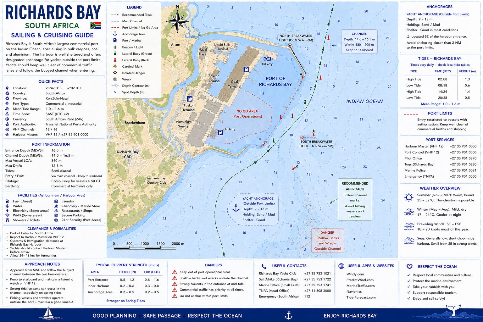
Richards Bay Yacht Cruising Guide. Richards Bay lies on the KwaZulu-Natal coast approximately 85 nautical miles northeast of Durban. The harbour was constructed within the former Mhlathuze lagoon system and now handles coal, dry bulk cargo, liquid bulk cargo, forestry products, fishing vessels, service craft and yachts. Recreational yachts use the Small Craft Harbour and the facilities operated by Zululand Yacht Club. All harbour movements remain under Richards Bay Port Control because yachts share the entrance and inner channels with bulk carriers, tugs and pilot vessels. The harbour functions as a South African maritime port of entry for international yachts.
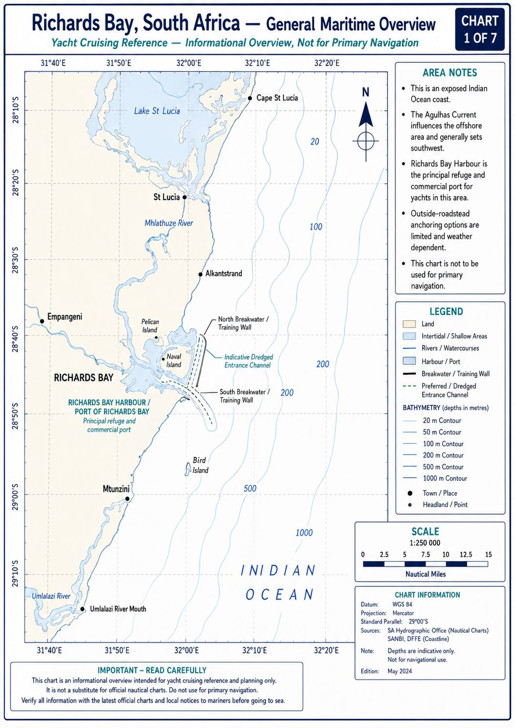
The offshore passage lies beside the Agulhas Current, which flows southwest along the KwaZulu-Natal continental shelf. The shelf narrows near Richards Bay, allowing the main current to approach closer to the coast than it does within the Natal Bight farther south. Strong southwest wind opposing the current creates the controlling offshore sea-state hazard. The harbour entrance is dredged for commercial shipping and remains accessible at all tidal states, but the inner small-craft channels and yacht berths have lower depths. Navigation depends on Port Control clearance, corrected official charts and current information from Zululand Yacht Club.
Richards Bay Yacht Cruising Guide - History
The Richards Bay coast and Mhlathuze lagoon were occupied by Zulu communities before construction of the modern port. The Mthiyane clan occupied land around the lagoon and used the estuary for fishing, livestock watering, transport and access to coastal resources. Regional heritage surveys record shell middens, stone artefacts, graves and settlement evidence along the coastal plain and dune system. The lagoon supported fish, shellfish, reeds and mangrove habitat before industrial harbour construction altered the waterway. Archaeological material exposed during earthworks, erosion or dredging remains protected under South African heritage law.
The bay was named after Admiral Sir Frederick William Richards following British naval activity during the Anglo-Zulu War in 1879. Commercial use remained limited while the lagoon entrance was shallow and affected by sand movement. Construction of the deep-water harbour began in 1972 and required dredging, land reclamation, breakwater construction and the creation of a permanent connection to the Indian Ocean. The port opened in April 1976 to export coal carried by rail from inland mining areas. Subsequent development added dry-bulk terminals, liquid-bulk facilities, forestry-product berths, ship-repair services and the Small Craft Harbour.
Richards Bay Yacht
Cruising Guide - Approaches
From the south, approach outside the coastal surf zone while remaining clear of the commercial traffic route. The KwaZulu-Natal shoreline north of the Tugela River contains sandy beaches, river mouths and shallow inshore water without a continuous series of fixed offshore landmarks. Maintain water deeper than 30 metres until the Richards Bay lights, breakwaters and charted entrance agree with the electronic position. Bulk carriers can approach from seaward at low speed while awaiting pilot instructions. Do not cross ahead of a ship aligned with the harbour entrance.
From the north, account for the southwest set of the Agulhas Current before reducing the distance offshore. A yacht can be carried past the harbour latitude while maintaining a heading toward the entrance. Establish the course-over-ground track before closing the 30-metre contour. The low coastline and industrial background make the harbour entrance difficult to identify in rain or haze. Use radar ranges to the breakwaters and verify the entrance against the corrected official chart.
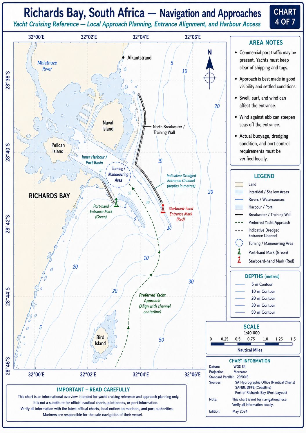
The outer approach contains no recreational waiting lane. Ships can anchor or manoeuvre under Port Control instructions outside the entrance, and pilot boats operate between the port and arriving vessels. Keep clear of pilot-transfer operations and vessels displaying restricted-manoeuvrability signals. Complete sail reduction and engine checks before entering the commercial approach sector. Do not conduct sail handling in the entrance channel.
Richards Bay Yacht Cruising Guide - Ocean Currents and Tides
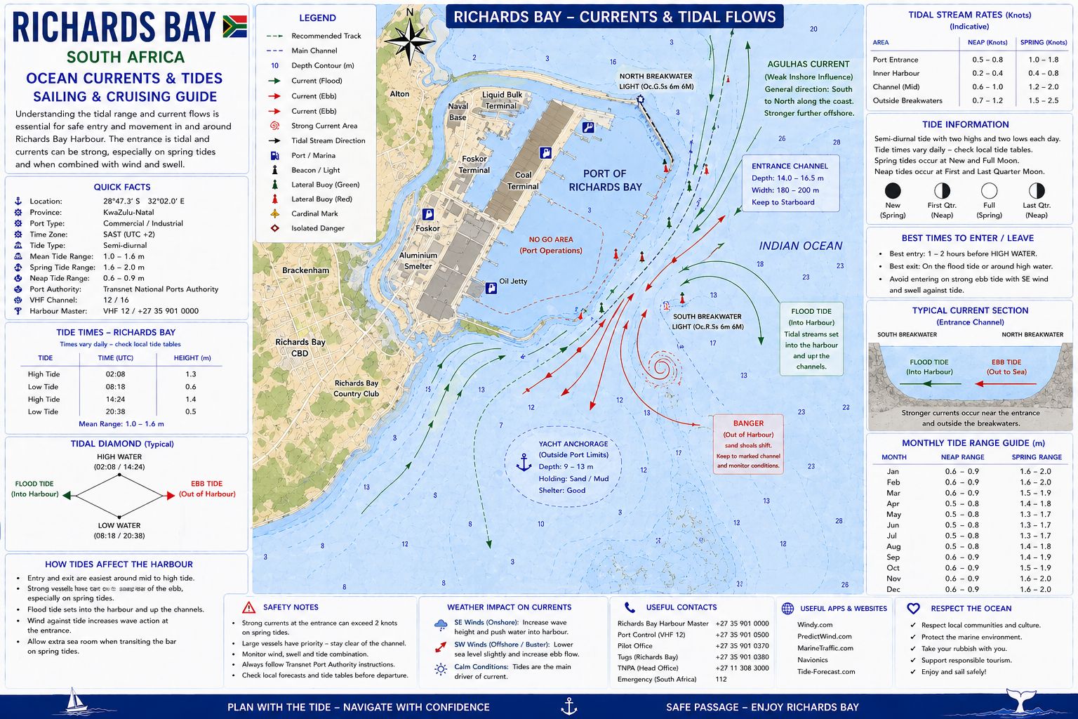
The Agulhas Current flows southwest outside Richards Bay and commonly produces a set of about 3 knots, with stronger movement in the current core. Its position changes through meanders, eddies and inshore intrusions. The narrow continental shelf north and east of Richards Bay allows current influence to extend close to the harbour approaches. A yacht approaching from the north can gain a following set, while a vessel heading north encounters an adverse current that can reduce speed over the ground (SOG) by several knots. Compare heading, speed through the water and course over ground rather than applying a fixed current correction.
Inshore water between the harbour entrance and the main current is less consistent. Coastal countercurrents, wind-driven flow and eddies can produce northeast movement close to shore while the main Agulhas Current continues southwest offshore. A southwest wind opposing the current produces short wave spacing, steep faces and breaking crests outside the harbour. Do not enter the current core during an established southwest gale. Remain inside the weaker coastal flow only where charted depths, sea room and traffic permit.
Richards Bay has a semi-diurnal tide with two high waters and two low waters during each lunar day. Spring ranges are normally about 1.8–2.0 metres, reducing to approximately 0.6–0.8 metre during neap periods. Tidal streams in the commercial entrance are weak compared with wind set, tug wash and propeller flow. Tide height affects under-keel clearance in the Small Craft Harbour, along the yacht-club approach and at individual moorings. Use the current South African tide table for Richards Bay and apply predicted height to chart datum.
Richards Bay Yacht Cruising Guide - Navigation
Contact Richards Bay Port Control on VHF Channel 12 before entering the controlled port approach. State the yacht’s name, call sign, position, length, beam, draught, last port, clearance status and intended berth. Maintain a listening watch on Channels 12 and 16 and keep AIS transmitting. Port Control can direct the yacht to wait, enter, cross the commercial channel or proceed toward the Small Craft Harbour. Do not enter the harbour or cross a ship’s track without direct clearance.
The commercial entrance channel carries approximately 19.5 metres at chart datum, with permissible commercial draught controlled by the port authority. These dimensions do not apply to the Small Craft Harbour approach or yacht-club berths. Enter between the main breakwaters on the side of the channel directed by Port Control. Maintain separation from tugs, pilot boats and deep-draught vessels. A bulk carrier constrained by draught cannot alter course to avoid a yacht inside the channel.
After clearing the commercial entrance, follow Port Control instructions toward the Small Craft Harbour. Shoaling occurs along the margins of the recreational route, and dredged depth cannot be assumed outside the marked channel. Do not use an old electronic track where buoy positions, dredging or sand movement have changed. Contact Zululand Yacht Club before reaching the inner harbour and obtain an assigned berth, mooring or anchorage position. Proceed at minimum wash near pontoons and moored vessels.
International arrivals do not proceed directly to a private yacht-club berth unless Port Control and the clearance authorities have issued that instruction. Use the designated clearance position assigned on arrival. Keep every person aboard until release by the required authorities. After clearance, obtain permission before shifting to Zululand Yacht Club.
Richards Bay Yacht Cruising Guide - Lighthouses and Lights
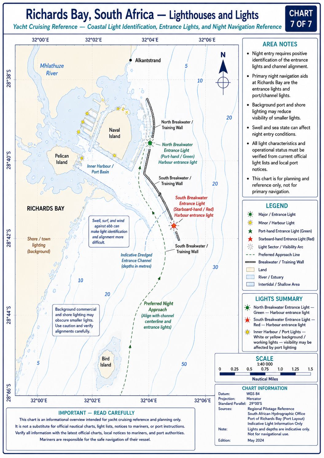
Richards Bay Main Light — D6483. The Richards Bay main coastal light is positioned near 28°46.54′S, 32°07.67′E north of the harbour entrance. The permanent light has been recorded out of operation under a current South African navigation warning. A temporary light has been installed near 28°46.5′S, 32°07.7′E. The temporary structure is approximately 12 metres high, has a night range of about 21 nautical miles and displays the same characteristic allocated to the permanent light.
Treat the temporary light as the operative aid until the navigation warning is cancelled. The light identifies the Richards Bay sector but does not establish an entrance track. Confirm the current status in the South African List of Lights and Notices to Mariners before departure.
Richards Bay Leading Lights — D6483.2 and D6483.21. The front leading light stands near 28°47.50′S, 32°02.16′E. The rear leading light stands near 28°47.22′S, 32°01.32′E. Together they define a commercial harbour transit used for controlled ship movements. Industrial buildings, terminal lighting and cranes can obscure the structures after dark. Do not occupy the commercial leading line without Port Control clearance. A yacht directed across the line must cross without delay and then remain outside the ship channel. Verify the current light characteristics in the corrected List of Lights.
South Breakwater Light — D6483.4. The South Breakwater light stands near 28°48.87′S, 32°05.86′E. Its characteristic is Fl W 3s, displaying one white flash every 3 seconds. The focal plane is approximately 16 metres, and the nominal range is about 18 nautical miles. It marks the southern side of the main harbour entrance.
North Breakwater Light — D6483.45. The North Breakwater light stands near 28°48.36′S, 32°05.88′E. It marks the northern entrance structure. Confirm its current colour, period, range and operational status from the corrected List of Lights. Spray and industrial background lighting can reduce its definition.
North Headland Light — D6483.5. The North Headland light stands near 28°48.39′S, 32°05.56′E. It identifies the landward side of the northern entrance works. Do not confuse it with the North Breakwater light when approaching from east or northeast. Use radar and charted positions to separate the two structures.
Pelican Island Groynes — D6483.52, D6483.53 and D6483.54. Lights mark the groynes and structures around Pelican Island and the inner harbour. These aids identify fixed obstructions within the harbour and do not form a yacht leading line. Keep outside every marked structure unless the charted channel and Port Control instructions permit passage. Current characteristics must be checked because temporary works can alter the local marking arrangement.
East Breakwater Light — D6483.57. The East Breakwater light stands near 28°47.96′S, 32°05.46′E. It marks an internal breakwater affecting the route toward the Small Craft Harbour and adjacent port areas. Do not pass on the wrong side of the structure by following shore lighting or an old electronic route.
Small Craft Harbour Tug-Berth Light — D6483.61. The tug-berth head light stands near 28°47.71′S, 32°04.81′E. Tug movements can obscure this light or place a vessel across the small-craft route. Maintain minimum wash and comply with any instruction to wait clear of the tug berth.
Small Craft Harbour Quay Lights — D6483.62 and D6483.63. Lights mark quay structures in the Small Craft Harbour. They identify fixed berth faces and do not indicate a free visitor berth. Proceed only to the berth allocated by the harbour authority or yacht club. Fishing and service vessels can project beyond the lighted quay line.
Coal-Terminal and Turning-Basin Leading Lights. The harbour contains further paired leading lights associated with the coal berths, turning basins and commercial channels, including D6483.64, D6483.65, D6483.68, D6483.681, D6483.7, D6483.71, D6483.8, D6483.81, D6483.9 and D6483.91. These lights serve deep-draught commercial traffic. They do not define a recreational route to Zululand Yacht Club. Do not enter a terminal channel or align with a commercial transit unless Port Control directs the movement.
Richards Bay Yacht Cruising Guide - Chart Accuracy
Use SAN 1032, INT 7572, Approaches to Richards Bay, at approximately 1:37,500 for the outer approach. Use SAN 1033, INT 7571, Richards Bay Harbour, at approximately 1:12,500 for the entrance, commercial channels and Small Craft Harbour. SAN 132, Tongaat Bluff to Richards Bay, and SAN 133, Durnford Point to Leven Point, provide coastal passage coverage at approximately 1:150,000. Small-craft chart SAN SC12, Durban to Richards Bay, includes a Richards Bay Harbour inset at approximately 1:10,000.
Apply every current South African Notice to Mariners before arrival. The temporary Richards Bay light and the failure of the permanent D6483 light must be entered on both paper and electronic passage plans. Commercial dredging keeps the main channel under survey, but this does not establish the depth of yacht routes, anchorage margins or berth pockets. Electronic charts can retain obsolete marina outlines, including facilities that no longer operate. Compare the sounder, chart, buoy positions and current instructions throughout the inner harbour.
Richards Bay Yacht
Cruising Guide - Anchorage
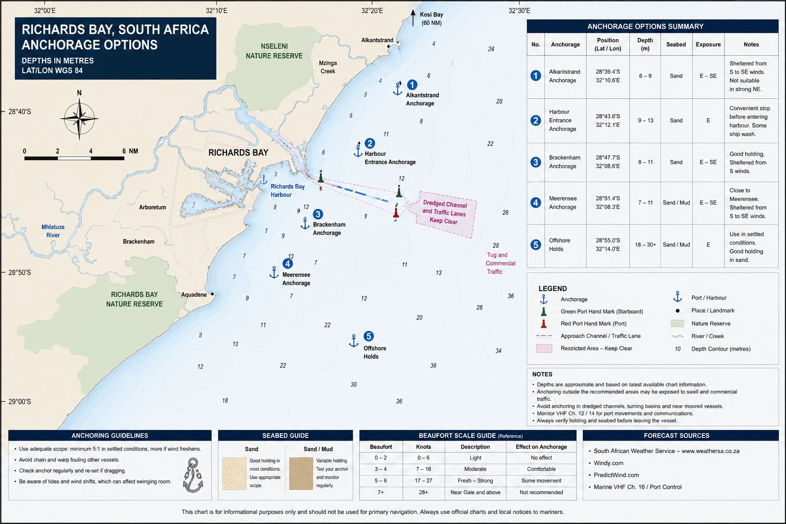
Zululand Yacht Club Anchorage. The protected yacht anchorage lies north of Zululand Yacht Club near 28°47.3′S, 32°04.9′E. Select a position in approximately 4–8 metres over mud and sand, clear of the yacht-club moorings, marked fairway and tug route. The seabed provides secure holding after the anchor penetrates the mud layer. Set the anchor under engine load and allow for complete wind reversal between northeast and southwest.
The position is protected from ocean swell by the harbour works. Strong northeast and southwest winds can still generate short chop and sustained ground-tackle load. Tug wash and workboat wake affect positions close to the fairway. Obtain the anchoring position from Zululand Yacht Club or Port Control rather than selecting a space between established moorings.
Zululand Yacht Club Visitor Moorings. Zululand Yacht Club allocates visitor moorings and marina positions according to vessel dimensions and availability. Depth varies between individual positions and cannot be derived from the commercial Small Craft Harbour depth. Provide the yacht’s loaded draught before accepting a mooring. Inspect the pickup line, visible chain and connection before leaving the vessel unattended. Visitor moorings provide protection from ocean swell but remain exposed to harbour gusts and wake. Do not pick up an apparently vacant buoy without allocation. Mooring loads increase during strong southwest changes and summer northeast cycles.
Small Craft Harbour Waiting Position. Port Control can allocate a temporary waiting position or quay inside the Small Craft Harbour. This is not a free anchorage. Use the position only for clearance, traffic control, emergency work or movement between facilities. Keep clear of tug berths, service quays and commercial access routes.
Outer Richards Bay Roadstead. The open coast outside Richards Bay does not provide a viable yacht anchorage. The seabed shoals toward a surf-backed sandy shore, and the position remains exposed to northeast swell, southwest wind and traffic entering the commercial harbour. The Agulhas Current can alter the yacht’s position outside the shelf. Remain underway or use the position assigned by Port Control rather than anchoring near the entrance.
Tuzi Gazi Marina. Tuzi Gazi Marina was destroyed during the 2022 storm event and is not an operating visiting-yacht marina. Do not plan a berth, fuel stop or clearance position based on older cruising guides showing this facility. The surrounding waterfront and channel remain within the controlled harbour, but access depends on current Port Control instructions.
Richards Bay Yacht
Cruising Guide - Entry Formalities
Richards Bay is a South African maritime port of entry and departure. International non-SOLAS yachts must complete the national pre-arrival authorisation process before arrival. Submit the required vessel, crew, passport, voyage and clearance information at least 96 hours before reaching the port. Update the estimated arrival time when passage conditions materially change it.
Notify Port Control on VHF Channel 12 that the yacht requires international clearance. Proceed to the berth or wall assigned for Port Health, Border Management, Immigration and Customs attendance. No crew member lands and no goods, rubbish, animals or equipment leave the yacht before release. Port Control, rather than an old cruising-guide waypoint, determines the current clearance position.
Carry the vessel registration, insurance, crew list, passports, last-port departure clearance and Customs declaration. Declare firearms, ammunition, controlled medicines, cash, alcohol, tobacco, commercial goods and equipment intended for sale. Meat, dairy products, plants, seeds, fresh produce, animals and animal products remain subject to agricultural or veterinary controls. International waste requires an approved disposal arrangement.
After completing South African arrival clearance, further domestic harbour calls do not require repeat Customs and Immigration attendance unless the yacht’s status changes. Complete the required coastwise passage plan before leaving Richards Bay for another South African port. International departure clearance must be completed before sailing from South African waters.
Starlink and other satellite communication terminals remain subject to South African electronic-communications licensing, spectrum and equipment-approval requirements. A foreign roaming account does not create a local exemption. Port security can direct that transmitting equipment be switched off in a controlled area.
Drone operation is subject to South African civil-aviation law, Richards Bay airspace, port-security controls and landowner permission. Do not launch from the yacht club, clearance berth, commercial harbour or a yacht inside the controlled port without written approval. Flights over ships, terminals, fuel installations, harbour personnel and restricted infrastructure are prohibited without the applicable authorisations.
Richards Bay Yacht
Cruising Guide - Marina Facilities
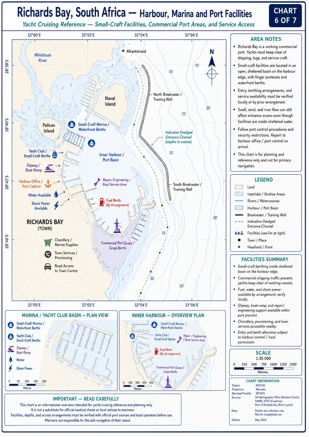
Zululand Yacht Club. Zululand Yacht Club lies at approximately 28°47.529′S, 32°05.015′E within the Small Craft Harbour. It is the principal operating yacht facility at Richards Bay. Visiting yachts use assigned marina berths, trot moorings, swing moorings or the adjacent authorised anchorage. Advance contact is required because visible vacant space does not establish availability.
Berth and fairway depths are position-specific. The commercial Small Craft Harbour has published depths greater than those found close to some yacht-club moorings. Confirm the complete route and berth depth for the yacht’s loaded draught. Do not use historical Tuzi Gazi depth information for the Zululand Yacht Club approach.
The club provides ablutions, a clubhouse, a restaurant, swimming-pool access, a boatyard and working areas. Water is available at authorised yacht-club points. Shore power is berth-specific and requires confirmation of voltage, socket type and amperage before connection. Do not run hoses or power leads across access routes without protection. The club office operates approximately 08:00–14:00 Monday to Friday and 08:00–12:00 Saturday. Arrange weekend or after-hours arrival before reaching the harbour. Port Control can authorise entry but does not allocate a yacht-club berth.
The club boatyard has a dolly with a maximum capacity of approximately 20 tonnes and a maximum accepted draught of about 2.1 metres. The current travel-lift limit is approximately 16 tonnes. Two scrubbing pads are available, together with arrangements for multihull beaching or scrubbing where dimensions and tide permit. Haul-out acceptance depends on loaded displacement, beam, keel configuration and lifting geometry. A yacht remaining for an extended period must comply with club membership, liveaboard, insurance and safety-document requirements. Permanent occupation of an unallocated berth is prohibited. Contractors and delivered equipment remain subject to club and port-access controls.
Small Craft Harbour Quays. Commercial and government quays inside the Small Craft Harbour are not general marina berths. Port Control can allocate a yacht temporarily for clearance, repairs or traffic management. Water, electricity and shore access are not guaranteed at every quay. Fishing vessels, tugs and port craft retain operational priority.
Alternative Berthing. No second fully operating visiting-yacht marina is confirmed inside Richards Bay. Tuzi Gazi Marina is not available. A yacht unable to obtain a Zululand Yacht Club position must use the anchorage or temporary position allocated by Port Control. Durban is the next major yacht-service port to the southwest.
Richards Bay Yacht
Cruising Guide - Local Weather
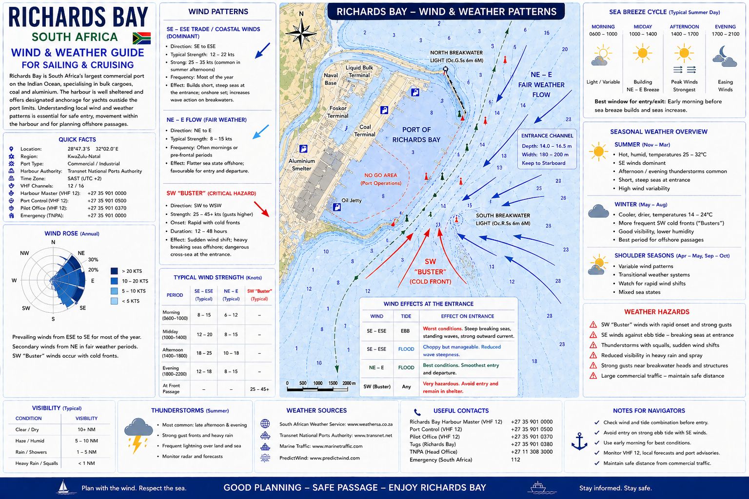
Richards Bay has warm, humid summers with frequent rainfall, thunderstorms and periods of northeast wind. Summer convection develops over the coastal plain and can move across the harbour with heavy rain, electrical activity and short-duration gusts. Visibility can fall below the distance required to identify harbour marks. Squall lines can reverse or increase the wind before the rain reaches the yacht. Maintain radar, AIS and engine readiness when thunderstorms are moving toward the harbour approaches.
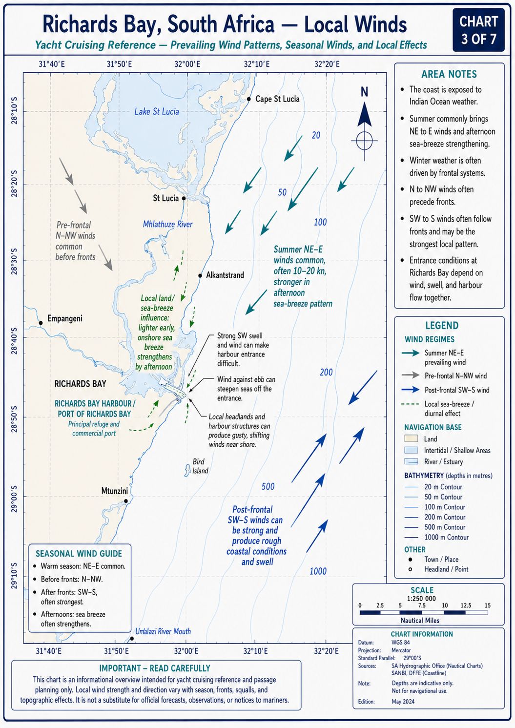
Winter conditions are drier, with longer settled periods between cold fronts. A front normally produces a hot offshore or northwest wind before the pressure falls and the wind changes southwest. The southwest change can reach Richards Bay as a defined squall line with a rapid temperature drop, increased wind and steepening sea. The offshore sea deteriorates faster where the new wind meets the south-going Agulhas Current. A yacht outside the harbour requires enough sea room to remain clear of the entrance traffic while reducing sail or waiting for clearance.
Direct tropical-cyclone landfall at Richards Bay is uncommon. Tropical systems in the Mozambique Channel or southwest Indian Ocean can still produce long-period northeast or east swell, heavy rain and abnormal wind patterns along the KwaZulu-Natal coast. These effects can arrive before the system’s cloud field reaches the area. Do not use distance from the cyclone centre as the sole measure of harbour-approach conditions.
Richards Bay Yacht Cruising Guide - Local Winds
The northeast wind is the main warm-season coastal wind. It normally develops after the morning and can reach 15–25 knots during an established pressure gradient. The wind acts along the KwaZulu-Natal coast and can build a short sea over the inshore shelf. Prolonged northeast wind raises humidity and can precede thunderstorms or a southwest change. It produces crosswind at parts of the harbour entrance and across the Small Craft Harbour.
The southwest wind is the controlling passage wind. It commonly follows a cold front or coastal low and can increase from light wind to gale force within a short period. When it opposes the Agulhas Current, wave height increases and crests begin breaking before the local wind reaches its maximum. A strong southwest change can remain active for several hours and then decrease rapidly. Do not depart northbound into the Agulhas Current while a southwest change is established.
A berg wind arrives from west or northwest after descending from the interior. It produces higher temperature, lower humidity and haze or smoke. The offshore phase can leave the inshore sea flat while a front approaches from the south or southwest. Secure the yacht for the later change rather than treating the berg wind as a settled offshore pattern.
Richards Bay Yacht
Cruising Guide - Provisioning
Supermarkets. Pick n Pay Super, Food Lover’s Market, Woolworths and Checkers provide the main supermarket supply in Richards Bay. Pick n Pay Super, Food Lover’s Market and Woolworths operate at Boardwalk Inkwazi Shopping Centre at 11 Penny Lane, approximately 8–10 kilometres by road from Zululand Yacht Club. Checkers operates from the Richards Bay commercial area, with an additional Checkers Centre serving the town. A road vehicle or delivery arrangement is required for bulk provisioning.
Boardwalk Inkwazi’s published general hours are 09:00–18:00 Monday to Thursday, 09:00–19:00 Friday, 09:00–17:00 Saturday and 09:00–15:00 Sunday and public holidays. Individual supermarkets open earlier or close later. Food Lover’s Market normally trades from about 08:00 and closes between 16:00 and 19:00 according to the day. Confirm same-day hours before arranging transport.
Checkers Centre publishes general hours of 08:00–17:00 Monday to Friday, 08:00–15:00 Saturday and 08:00–13:00 Sunday and public holidays. Checkers itself normally remains open beyond the centre’s general hours.
Markets. Richards Bay has no verified fixed daily municipal produce market. Blackwoods Market operates at announced events in the Meerensee area, normally on selected Saturdays, with hours commonly running from approximately 08:00–15:00. Dates change according to the organiser’s programme. Do not base offshore provisioning on this market without confirming the current event date. Fresh produce is supplied through Food Lover’s Market, supermarket produce departments and independent town retailers. No wholesale public market operates beside the Small Craft Harbour.
Fish Markets. Richards Bay Fresh Fish Distributors provides retail seafood according to current stock and commercial supply. Fixed public hours and the collection location require confirmation before travelling. Supermarket fish counters at Boardwalk Inkwazi provide an alternative controlled retail source. The commercial port’s fishing and service quays are not public fish markets.
Regional species include couta, meaning king mackerel; dorado, also called mahi-mahi; yellowfin tuna; queen mackerel; shad, called elf; kob, also called daga salmon; geelbek, known as Cape salmon; rockcod or grouper; queenfish; prawns and squid. Availability depends on legal landings, closed seasons, catch limits and weather. Recreational catches cannot be sold.
Richards Bay Yacht
Cruising Guide - Local Cuisine
Richards Bay cuisine reflects coastal KwaZulu-Natal cooking, Zulu food traditions and seafood from the Indian Ocean. Grilled line fish, king mackerel, dorado, prawns and squid are prepared over coals, fried or cooked in spiced sauces. Fish curry uses tomato, onion, garlic, chilli and Indian Ocean spices. Prawn curry reflects the Indian cooking influence found throughout KwaZulu-Natal. Ujeqe is steamed bread served with meat, beans or gravy. Umngqusho combines samp and beans and can be served with beef or chicken. Phuthu is crumbed maize meal eaten with beans, meat, sour milk or vegetable relish. Chakalaka is a cooked vegetable relish containing onion, tomato, beans, carrot and chilli. Umleqwa is free-range chicken cooked slowly until tender. Ulusu is tripe prepared with seasoning and served with maize meal or steamed bread. Inyama yenhloko is meat taken from a cooked cattle head and served in portions. These foods belong to regional Zulu cooking.
Bunny chow consists of curry served inside a hollowed loaf of bread and reflects the wider KwaZulu-Natal Indian food tradition. The filling can contain beans, chicken, mutton or beef. Seafood versions exist but are not the original form. Local supply of tropical and subtropical produce includes bananas, avocados, mangoes, pineapples and sugarcane products.
Richards Bay Yacht Cruising Guide - Beverages
National beers sold locally
include Castle Lager, Castle Lite, Carling Black Label and Hansa Pilsener.
KwaZulu-Natal and South African craft beer is distributed through licensed
retailers. Umqombothi, also called utywala, is a traditional beer
made from maize, maize malt, sorghum malt, yeast and water. It has a low
alcohol content and is produced for household, ceremonial and licensed
commercial use. Amahewu is a non-alcoholic fermented maize drink. South
African brandy, gin, cane spirit and Amarula are available through licensed
outlets.
Richards Bay Yacht
Cruising Guide - Fuel Supplies
Richards Bay is a commercial bunkering port, but commercial fuel installations are not unrestricted yacht fuel docks. Yacht-scale diesel requires arrangement through Zululand Yacht Club, a harbour supplier or an approved road-delivery contractor. Confirm the fuel grade, quantity, delivery berth, payment method and access authority before moving the yacht. Port Control approval is required where the transfer involves a shift through harbour traffic.
A road tanker can deliver larger quantities at an authorised quay or boatyard position. The supplier, port authority and yacht club must approve vehicle access and hose routing. The transfer cannot obstruct tug operations, emergency access, the travel lift or adjacent berths. Bonded fuel for international departure requires the applicable Customs and supplier procedure.
Road diesel is available from filling stations in Richards Bay for carriage in approved containers. Repeated container transfer through the harbour or yacht-club gate requires permission. Containers must remain sealed, upright and secured. Do not store portable fuel on a pontoon or beside shore-power equipment.
Take a clear sample from the first fuel transferred and inspect it for water and sediment. Use the yacht’s deck-fill strainer and primary water-separating filter. Stop filling before diesel reaches the tank vent. Report every spill immediately and prevent contaminated wash water from entering the harbour.
Richards Bay Yacht
Cruising Guide - Water Supplies
Municipal fresh water is available at authorised Zululand Yacht Club connections and working points. Supply at an individual berth is not guaranteed until the berth allocation is confirmed. Use only the outlet assigned by club staff. A commercial washdown or fire connection cannot be treated as a potable-water source.
Flush the outlet before connecting the yacht’s hose. Use a hose reserved for drinking water and keep its end off the pontoon and out of harbour water. Richards Bay’s warm conditions increase bacterial growth in hoses and partially filled tanks. Apply onboard filtration and tank treatment where fitted.
Municipal repairs, pressure reduction or local restrictions can interrupt supply. Confirm availability before emptying an onboard tank or beginning a large fill. Do not leave a filling hose unattended. Bottled water is available from the town supermarkets. No routine water-barge service operates for yachts anchored beside Zululand Yacht Club. An anchored yacht must transfer containers by tender or move to an authorised water point under club instruction.
Mechanical and Electrical Repairs
Resource
Why not get a copy of my book The Marine and Electrical and Electronics Bible 4th Edition. In Australia and New Zealand order a copy through Boat Books. UK and European boats can buy the UK Edition Here. US and Canadian boats can get the US Edition Order Here. Marine systems are my profession so let me help you. In South Africa you can buy the book through Amazon or Loot.co.za or Kobo.co.za


Richards Bay Yacht
Cruising Guide - Marine Services
Zululand Yacht Club provides the main yacht-scale haul-out and maintenance facilities at Richards Bay. The club dolly handles vessels up to approximately 20 tonnes with a maximum draught near 2.1 metres. The travel lift handles vessels up to approximately 16 tonnes. Scrubbing pads and multihull working arrangements are available where tide, dimensions and yard operations permit.
No locally verified authorised Raymarine, B&G or Simrad service agent is based at Zululand Yacht Club. No locally verified authorised Volvo Penta, Yanmar, Nanni Diesel, Vetus or Beta Marine inboard-engine agent is based inside Zululand Yacht Club or the Small Craft Harbour. The Richards Bay industrial port supports diesel mechanics, electricians, hydraulic contractors, refrigeration technicians, divers and heavy-equipment services. Access to these contractors depends on port security and yacht-club approval. Obtain or define the work scope in writing, the labour rate and parts availability before dismantling an operational system.
OSASA - South African Yacht
Assistance
The Ocean Sailing Association of Southern Africa (OSASA) came into being during the COVID pandemic crisis where they actively assisted entry to South Africa by cruising yachts into its various ports. It is a non-profit company created to liaise with Maritime officials to facilitate entry to South African ports at the time. OSASA was assigned by the SA Department of Transport to handle the mandatory pre-arrival authorisation (PAN) for all incoming non-SOLAS yachts, both local and foreign. OSASA services include the following:
- Manage and update the online registration portal for incoming non-SOLAS vessels
- Manage the pre-arrival authorisation (PAN) process with the Department of Transport for incoming small vessels at the Ports of Entry
- Provide up-to-date information for cruising yachts navigating South African ports and coastal waters
- Develop and maintain a good working relationship with SA maritime authorities and port officials, and with local offshore yacht clubs and marinas
- Work with local offshore clubs and marinas to develop and enhance their facilities
Cruising yacht visitors are encouraged to contact OSASA. They are a group of willing and like minded volunteers along the South African coastline and will assist with the needs of cruising yachts. This group is known as the OSASA Port Ambassadors and will assist cruising yachts with anything that may be required. Anything from entry procedures right down to directing you to the nearest dentist or barber and anything in-between. There is a published list on the OSASA website as well as on the Sail to South Africa WhatsApp group of the individual OSASA port Ambassadors. Ports and marinas that are covered are Richards Bay; Durban; East London; Port Elizabeth; Port St. Francis; Knysna; Mossel Bay; Gordon's Bay, False Bay YC (Simon's Town), Hout Bay, Saldanha Bay; Port Owen; Cape Town (V&A Waterfront and Royal Cape YC).
Richards Bay Yacht
Cruising Guide - Local Etiquette
Richards Bay is a controlled commercial port. Bulk carriers, tugs, pilot vessels and port-service craft retain priority in every commercial channel. Follow Port Control instructions without informal alteration. Do not cross a ship’s bow, enter a terminal basin or wait on a commercial leading line.
Coal terminals, dry-bulk facilities, liquid-bulk berths and industrial quays are restricted areas. Crew access is limited to the yacht club, authorised roads and the route specified by port security. Do not photograph terminal equipment, security installations, ships or clearance operations after a restriction has been issued. Register visitors, vehicles and contractors before they arrive at the gate.
Zululand Yacht Club moorings and berths are allocated. Do not occupy a vacant buoy, shift another yacht’s lines or use a private berth without permission. Keep pontoons, travel-lift routes and working areas clear of tenders, bicycles, fuel containers and equipment. Reduce wash throughout the Small Craft Harbour.
English and isiZulu are the main local working languages. Begin an interaction with a greeting before stating the vessel request. Sawubona is an isiZulu greeting to one person, while Sanibonani addresses more than one person.
Richards Bay Yacht
Cruising Guide - Summary
Richards Bay is a deep-water commercial port and a South African maritime port of entry. Yacht movements require Port Control clearance on VHF Channel 12 and separation from bulk carriers, tugs and restricted terminal areas. Zululand Yacht Club provides the principal visitor moorings, anchorage, haul-out facilities and access to local technical work, while Tuzi Gazi Marina is no longer operating. These navigation, clearance and marina requirements define the Richards Bay Sailing and Cruising Guide. Richards Bay Yacht Cruising Guide for all you need to know