Lesvos Greece
Sailing Guide
Lesvos Greece Sailing Guide. Lesvos (Lesbos) lies in the north-eastern Aegean Sea close to the Turkish coast, at approximately 39°10′N 26°20′E and is one of the largest islands in Greece. The island offers a varied coastline with large gulfs, open bays, and numerous smaller anchorages, providing a wide range of berthing and shelter options. Its scale and geography create diverse cruising conditions, with more exposed northern and western coasts and more protected waters within major inlets such as the Gulfs of Kalloni and Gera.
For cruising yachts, Lesvos functions as both a destination and a regional hub within the North Aegean, with established ports including Mytilene, Molyvos, and Sigri supporting navigation, provisioning, and services. The island sits on common passage routes between the northern Dodecanese, Chios, and the Turkish coast, making it a practical staging point as well as a cruising ground in its own right. Conditions are generally less predictable than in the southern Aegean, with variable winds and fewer sheltered options on exposed coasts, but balanced by extensive anchorages and well-developed mainland-style infrastructure.
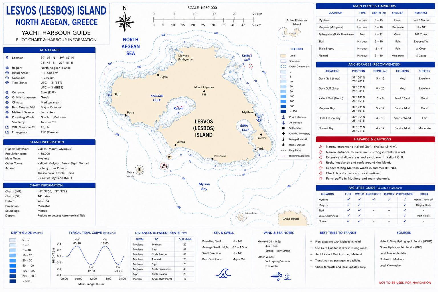
Chart Disclaimer. This chart is a schematic representation for illustrative purposes only and must not be used for navigation. Refer to official hydrographic charts for safe navigation. Be aware ENC charts may differ from official hydrographic charts. Both should be corrected and updated regularly.
Lesvos Greece
Sailing Guide History
Lesvos has a long and continuous history as a major cultural and maritime centre in the north-eastern Aegean Sea. In antiquity, it was one of the most important islands of the Greek world, known for its prosperity, trade, and intellectual life. It was the birthplace of Sappho and Alcaeus, reflecting its role as a centre of early Greek culture and literature.
Under successive rule by classical Greek city-states, the Roman Empire, and the Byzantine Empire, Lesvos retained its importance as a regional hub. In the medieval period, it came under the control of the Genoese Gattilusio family, who fortified key settlements such as Mytilene Castle and Molyvos Castle to defend against piracy and invasion. The island later passed to Ottoman control, where it remained for several centuries, functioning as an agricultural and trading centre.
Lesvos was incorporated into modern Greece in the early 20th century following the Balkan conflicts, after which it developed as an administrative and commercial centre for the North Aegean. Today, the island retains a strong cultural identity shaped by its long history, with its ports continuing to serve as important links between Greece, the eastern Aegean islands, and the nearby Turkish coast.
Lesvos Greece
Sailing Guide - Approaches
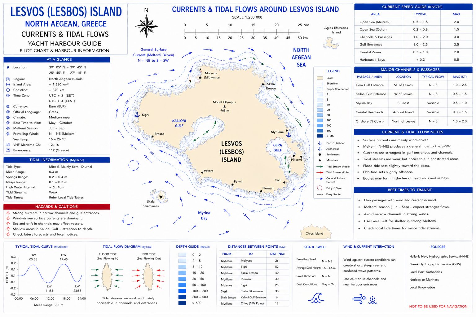
Approach is from open water with depths exceeding 50–100 m offshore, reducing to 5–10 m approaching harbour limits and bays. Entry to Mytilene is direct with a wide approach. The Gulfs of Kalloni and Gera provide large enclosed waters with reduced sea state. Sea state is wind driven. Meltemi (N–NW) produces strong winds and steep seas on exposed coasts, particularly along the north and west. The gulfs provide reduced sea state and shelter from prevailing northerlies. Tidal range is typically 0.2–0.4 m with negligible tidal stream. Hazards include ferry traffic, crosswinds on harbour entry, and fishing activity within gulfs and near shore.
Lesvos Greece
Sailing Guide - Navigation
Navigation to Lesvos is conducted in open Aegean waters with generally good chart coverage and clear approaches from all directions. The island is large and prominent, with mountainous terrain visible from distance, providing strong visual reference for landfall. Depths offshore are typically 50–200 m, shoaling progressively toward the coast, though many areas remain deep close in due to steep-sided geography.
Approaches from the south and west are open water passages, while routes from the east involve crossing from the Turkish coast with relatively short distances. There are no major off-lying hazards on primary approach lines, but isolated rocks and shoal areas exist close inshore, particularly near headlands and within smaller bays, requiring standard caution when closing the coast.
Navigation becomes more varied once within the island’s major inlets. The Gulf of Kalloni and Gulf of Gera provide extensive sheltered waters, with depths reducing to 5–20 m inside, though both gulfs have narrow entrances requiring accurate pilotage. The main port at Mytilene lies on the south-east coast and serves as the primary navigation focal point, with ferry and commercial traffic requiring awareness on approach.
Wind conditions can influence navigation significantly, with northerly Meltemi winds creating short, steep seas on exposed coasts, while sheltered gulfs remain comparatively calm. Electronic navigation is reliable but should be cross-checked with official charts, and a lookout maintained for fishing activity and local traffic near coastal areas.
Lesvos Greece Sailing Guide - Ocean Currents and Tidal Flows
Lesvos Greece
Sailing Guide - Chart Accuracy
Charts issued by the Hellenic Navy Hydrographic Service are reliable for approaches and major harbour areas. ENC data aligns with official charts. Shallow areas and fishing installations within gulfs may not be fully represented on electronic charts.
Lesvos Greece
Sailing Guide - Anchorages
Lesvos provides multiple anchorages with generally good holding. No single anchorage provides full protection; conditions are wind dependent.
- Gulf of Kalloni provides extensive anchoring in depths of 3–10 m over mud with good holding and significant shelter from northerly winds.
- Gulf of Gera provides anchoring in 4–12 m over mud with good holding and enclosed protection.
- Petra and Molyvos areas on the north coast provide depths of 5–10 m over sand with moderate holding but exposure to northerly winds.
- West coast anchorages provide depths of 5–20 m but are exposed to prevailing winds and swell.
Lesvos Greece
Sailing Guide - Entry Formalities
Lesvos is a port of entry. Customs and immigration clearance is required for arrivals from outside Schengen areas. Vessel and crew documentation must be available. Movements to and from nearby Turkish ports require formal clearance procedures. Harbour authority control applies within port limits. Drones are regulated under Greek aviation rules. Communications equipment must comply with national regulations. Waste discharge is controlled.
Lesvos Greece
Sailing Guide - Marina Facilities
Berthing on Lesvos is distributed across several ports rather than a single marina, reflecting the island’s size and mainland-style infrastructure. The principal harbour is Mytilene Port on the south-east coast, where yachts berth along the town quay, typically stern-to using anchors. Depths alongside are generally 3–6 m, with deeper water in outer sections. The port is active with ferry and commercial traffic, and berthing space can be affected by wash and vessel movements. Basic services such as water and electricity are available on parts of the quay.
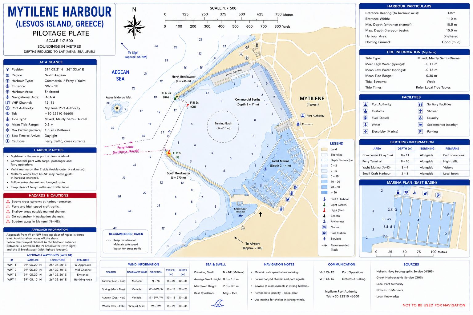
Additional berthing is available at Molyvos (Mithymna) Harbour on the north coast, a smaller but well-sheltered harbour offering stern-to and alongside berthing with depths of approximately 2–4 m. Facilities are limited but suitable for short stays. On the west coast, Sigri Harbour provides a more protected option in prevailing northerly conditions, with depths of 3–5 m and basic quay infrastructure.
Within the island’s gulfs, smaller harbours and quays offer additional options. The Gulf of Gera and Gulf of Kalloni contain several sheltered anchorages and minor berthing locations, generally with 5–15 m depths at anchor and good holding in mud or sand. These areas provide protection in most conditions but have minimal shore facilities.
There are no large, fully serviced marina complexes on Lesvos. Berthing is primarily quay-based or at anchor, with limited marina-style infrastructure. However, the range of ports and sheltered inlets provides flexible and reliable berthing options across different wind conditions, supported by adequate basic services in the main towns.
Lesvos Greece
Sailing Guide - Local Weather
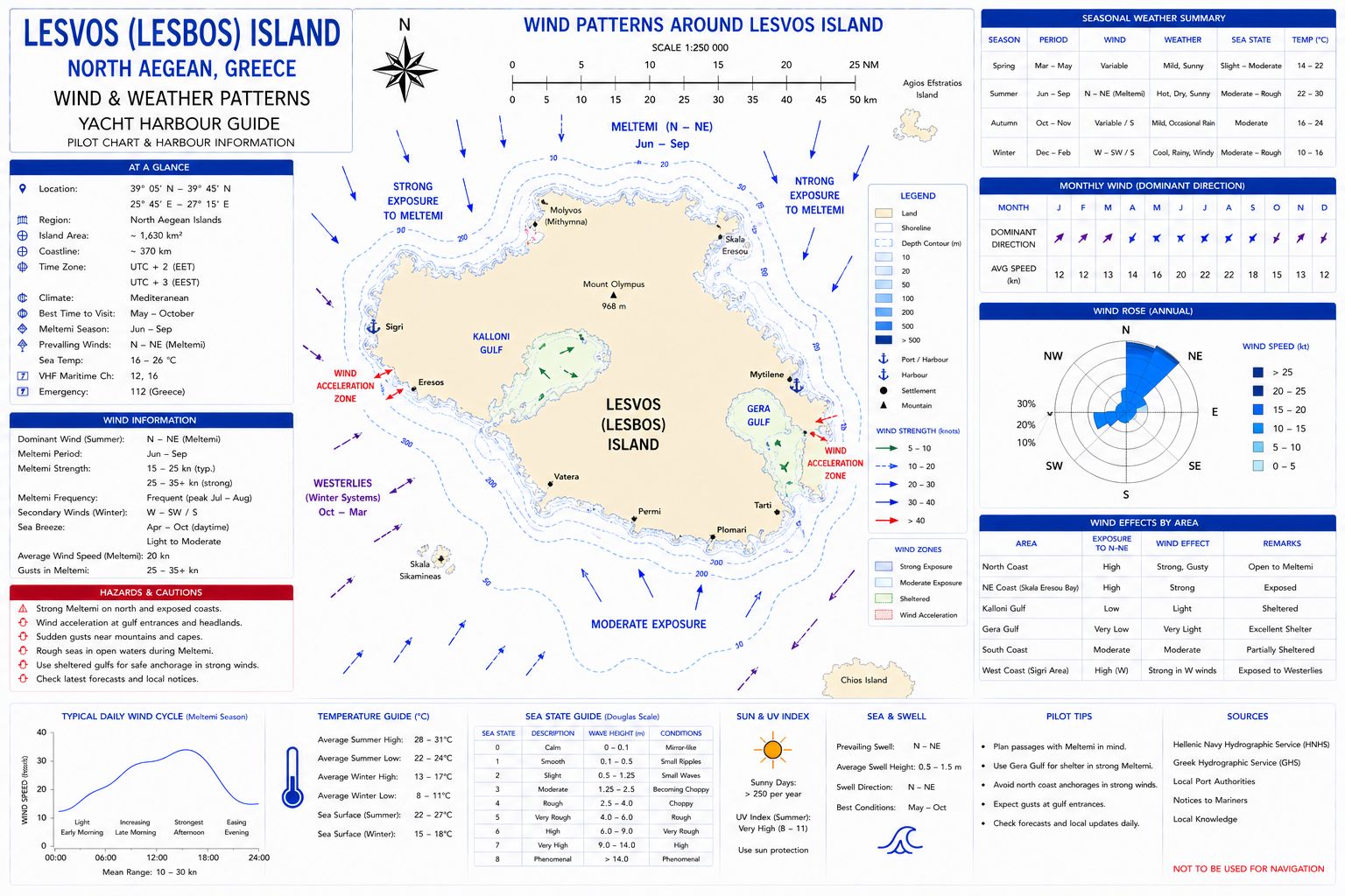
Weather on Lesvos is more variable than in the southern Aegean due to its northern position and proximity to mainland weather systems. Summer conditions are generally stable, but influenced by the Meltemi, typically blowing north to north-east at 15–25 knots, with stronger periods reaching 25–30 knots or more. This creates moderate to rough sea state along exposed northern and western coasts, while the large gulfs and southern shores remain significantly more sheltered.
Temperatures are warm to hot in summer with excellent visibility and minimal rainfall. However, compared to the Cyclades and Dodecanese, wind strength and direction can be less consistent, and periods of lighter winds or directional shifts are more common. Outside the main season, conditions become increasingly changeable, with southerly and easterly systems bringing cloud, rain, and longer-period swell.
The island’s size and topography create localised weather variation, with calmer conditions inside the Gulfs of Kalloni and Gera and stronger winds along open coasts. Overall, Lesvos offers mixed but manageable weather, combining Meltemi influence with more variable northern Aegean patterns.
The Marine Electrical and Electronics Bible has a complete list of Greek VHF Radio Channel information and weather forecast times for Greece along with NAVTEX UK and Europe and NAVTEX Mediterranean for 490kHz and 518kHz.
Lesvos Greece
Sailing Guide - Local Winds
Wind patterns around Lesvos are shaped by its position in the northern Aegean, combining Meltemi influence with more variable mainland weather systems. During summer, the prevailing wind is the Meltemi, typically blowing north to north-east at 15–25 knots, with frequent periods of 20–30 knots or more. These winds are strongest along the north and west coasts, where they generate short, steep seas and sustained exposure.
Conditions are notably different on the south and within the island’s large gulfs. The Gulf of Kalloni and Gulf of Gera provide significant shelter from northerly winds, often with reduced wind strength and calmer water, making them key refuge areas during strong Meltemi conditions. Local topography also produces gusts and acceleration around headlands, particularly where valleys and inlets funnel the wind.
Unlike the southern Aegean, Lesvos experiences more variability. Periods of lighter winds, directional shifts, or interruptions to the Meltemi are more common. Outside summer, wind patterns become less predictable, with southerly and easterly systems bringing unsettled conditions, stronger gusts, and longer-period swell. Overall, Lesvos presents strong but less consistent wind conditions, with pronounced contrasts between exposed coasts and sheltered gulfs, requiring careful route and anchorage planning.
The Meltemi is a strong, dry northerly wind that dominates the Aegean in summer, accelerating through channels and between islands to produce steep, short seas. It is most persistent in July and August, often blowing for several days with little diurnal variation, creating fast north‑to‑south passages and challenging return routes. Its strength is shaped by pressure gradients between the Balkans and Anatolia, with local acceleration zones around major island gaps.
Lesvos Greece
Sailing Guide - Provisioning
Supermarkets. Provisioning on Lesvos is extensive and mainland-level, with full resupply capability across the island. The main centre is Mytilene, where large supermarkets including Sklavenitis, AB Vassilopoulos, Masoutis, and Lidl provide complete provisioning, fresh produce, meat, dairy, frozen goods, dry stores, and beverages. Supply is continuous and reliable due to regular mainland logistics. Secondary towns such as Molyvos (Mithymna) and Kalloni also offer supermarkets and well-stocked local stores suitable for routine resupply, though with smaller range than Mytilene. Across the island, independent greengrocers, bakeries, butchers, and delicatessens provide daily fresh goods with high turnover. Lesvos has strong agricultural output, producing olive oil, vegetables, dairy, and herbs, all widely available in local shops. Bread and pastries are available daily from numerous bakeries
Markets. Provisioning is supported by weekly open-air markets (laiki agora) operating in towns and villages, offering seasonal vegetables, fruit, herbs, and local products. These markets are well supplied from the island’s agricultural base and surrounding mainland sources. There is no single central market, but distribution is widespread and consistent.
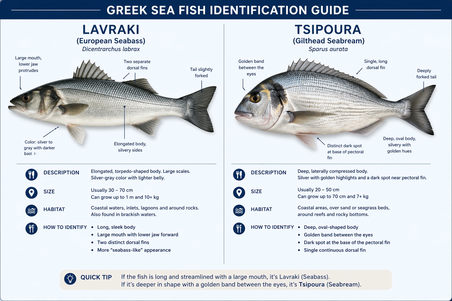
Fish Supply. Fish supply is reliable and varied, supported by local fisheries and northern Aegean distribution networks. Fishmongers operate in Mytilene and other towns, with daily availability of species such as lavraki (seabass), tsipoura (seabream), sardines, anchovies, squid, and octopus. Harbour-side sales occur in smaller ports aligned with local landings.
Lesvos Greece
Sailing Guide - Local Cuisine
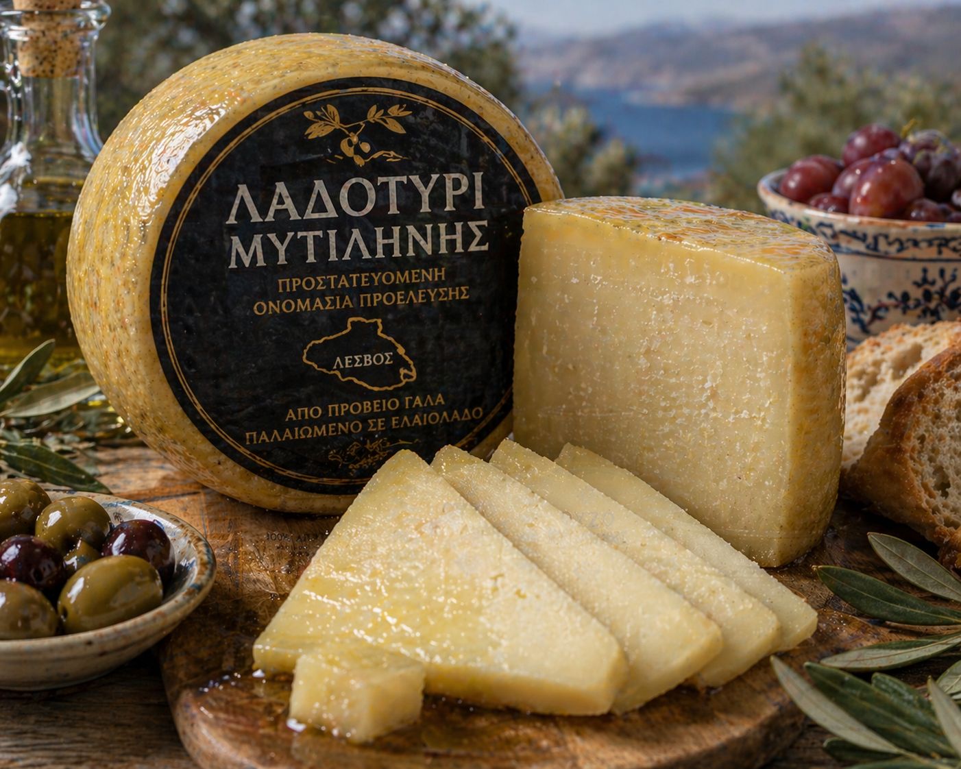
Famous for Ouzo and many varieties of olive oil. Cuisine on Lesvos is one of the most distinctive in the northern Aegean, shaped by strong agricultural production, olive oil culture, and coastal fishing, with several clearly identifiable local specialities. The island is particularly known for sardeles Kalloniou, small sardines from the Gulf of Kalloni, typically cured lightly in salt or served grilled, noted for their rich, oily flavour. Another defining product is Ladotyri Mytilinis, a hard sheep’s milk cheese aged in olive oil, giving it a firm texture and strong, slightly spicy taste.
Seafood is otherwise central, most commonly prepared as grilled fish such as lavraki and tsipoura, or in simple dishes using olive oil, lemon, and herbs. Olive oil production is extensive across Lesvos and underpins most cooking. Lesvos also has a strong tradition of preserved and meze-style foods. Dishes such as giouslemedes, small fried pastries filled with cheese or meat, and revithokeftedes, chickpea fritters, are widely served. Vegetables, legumes, and wild greens feature heavily, reflecting the island’s agricultural base.
Lesvos Greece
Sailing Guide - Beverages
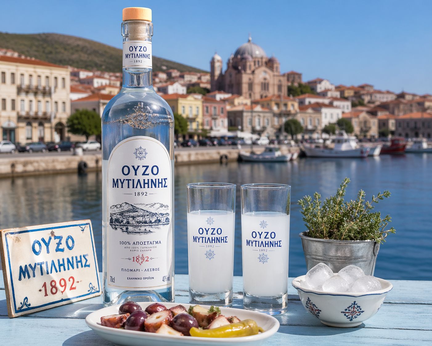
The island is closely associated with ouzo of Mytilene, one of Greece’s most recognised anise-based spirits, produced locally and typically served with meze. Beer, wine, and spirits across the Greek islands are locally produced and widely available through tavernas, small bars, and provisioning outlets. Beer is predominantly lager, with domestic brands including Mythos, Alfa, Fix, and Vergina alongside imported products; and over 100 microbreweries operate on several islands with limited distribution. Wine is region-specific, with white varieties dominant in the islands, including Assyrtiko, Moschofilero, and Roditis, alongside local table wines served in bulk; retsina remains in circulation as a resin-flavoured wine. Distilled products include ouzo (anise-based), tsipouro (grape marc distillate), raki or tsikoudia (Crete), souma (fig or grape distillate in eastern Aegean islands), and kitron (citrus liqueur from Naxos), with alcohol strength typically in the 37–45% range and higher for unregulated local distillations.
Lesvos Greece
Sailing Guide - Fuel Supplies
Fuel supply on Lesvos is
reliable and widely available, reflecting the island’s size and developed
infrastructure. The primary refuelling point is Mytilene Port, where marine
diesel is supplied via road tanker delivery to quay berths. Arrangements are made
locally, typically with short notice, and supply is consistent due to regular
mainland distribution. Additional fuel
availability exists at secondary ports such as Molyvos (Mithymna) Harbour and
Sigri Harbour, though in these locations delivery is more limited and should be
arranged in advance. There are no dedicated fuel docks or marina fuel berths on
the island. Petrol and LPG (bottled gas)
are readily available ashore through fuel stations across the island,
particularly in Mytilene and larger towns. No fuel is available at anchorages
or within the gulfs.
Lesvos Greece
Sailing Guide - Water Supplies
Water supply on Lesvos is reliable and widely available, particularly at the main ports. At Mytilene Port, potable water is supplied via quay connections, typically metered, with generally good pressure and consistent year-round availability due to mainland-supported infrastructure. Additional water supply is available at secondary ports such as Molyvos (Mithymna) Harbour and Sigri Harbour, though availability and pressure may be more limited and dependent on local systems. Within the Gulf of Gera and Gulf of Kalloni, smaller quays may offer intermittent supply, but this should not be relied upon.
Water quality is potable but can be moderately mineral-rich, making onboard filtration advisable for drinking use. No water is available at anchorages. Overall, Lesvos offers good water resupply capability across multiple ports, making it suitable for full tank replenishment during cruising in the North Aegean.
Mechanical and Electrical Repairs
Resource
If you are headed sto Lesvos or somewhere remote consider the need to expand your knowledge base or have an information resource on board. Why not get a copy of my book The Marine and Electrical and Electronics Bible 4th Edition. By and for yachties, with everything from batteries and charging, solar and wind, diesel engines and marine electronics and so much more. Your complete systems guide. 650 pages of practical advice. In Australia and New Zealand order a copy through Boat Books. UK and European boats can buy the UK Edition Here. US and Canadian boats can get the US Edition Order Here. Marine systems are my profession so let me help you. By a liveaboard boat owner for other boat owners.



Lesvos Greece
Sailing Guide - Marine Services
Marine services on Lesvos are well developed for the North Aegean, with the main centre at Mytilene. Here, support is available for diesel engines, electrical systems, and general yacht maintenance through local contractors and workshops. Chandlery supply is moderate, with access to essential parts and consumables, supported by regular mainland logistics. Lift-out and yard facilities are limited but available for smaller vessels, with more complex repairs and specialised work arranged through mainland or larger regional centres. Secondary ports offer minimal technical support.
Lesvos Greece
Sailing Guide - Local Customs
Interaction is direct and formal on first contact, with a greeting expected before any request or transaction. Conversation tone is measured and transactional, with limited small talk unless initiated locally. Personal space is closer than in northern Europe, but physical contact is minimal unless familiarity is established. Shore behaviour is conservative in non-tourist areas, particularly near churches and village centres where modest dress and low noise are expected.
Lesvos Greece
Sailing Guide - Summary
Lesvos provides large sheltered gulfs with good holding and reduced sea state. Exposed coasts are affected by strong Meltemi conditions. Harbour facilities are basic with multiple ports available. Provisioning and marine services are moderate with regional support. Lesvos Greece Sailing Guide for all you need to know.