Western Indonesia
Sumatra Sailing Routes
Western Indonesia Sumatra sailing routes. Western Indonesia Sumatra forms one of the most exposed and ocean‑influenced coastlines in the region, stretching from the northern entrance at Sabang (Weh Island) down the Indian Ocean arc through Nias, the Hinako Islands, the Batu Islands, the Telos Islands, and the full Mentawai chain. The coastline is shaped by deep ocean basins, volcanic slopes, reef systems, and surf‑affected approaches, with anchorages concentrated in narrow pockets of shelter rather than large protected harbours. The primary nodes include Nias, Gunungsitoli, Teluk Dalam, Hinako Islands, Batu Islands, Telos Islands, Mentawai Islands, Siberut, Sipora, North Pagai, South Pagai, Sabang, Padang, and Bungus.
Across this region, ports and villages provide only basic supplies, with no yacht‑grade water, fuel, or technical services. Movement between islands depends on swell conditions, seasonal wind shifts, and the absence of formal navigation aids. The region’s geography forces yachts to work with depth, light, and localised conditions rather than marked channels or harbour infrastructure. This hub page defines the operational logic of Western Indonesia Sumatra and links every port and island node into a single navigational framework.
Western Indonesia
Sumatra Sailing Routes - Operational
Context
Western Indonesia Sumatra has no marina infrastructure and only limited shore‑side support for yachts. Water uplift is unreliable and generally restricted to jerry‑can collection from communal taps, while diesel is available only from roadside stations with manual transfer. Approaches to most islands are shaped by reefs, surf, and deep drop‑offs, with many anchorages offering narrow shelves and limited swing room. Movement between regions depends on daylight navigation, swell awareness, and careful depth management, as night entry is unsafe across most of the coastline due to unlit hazards, surf zones, and reef systems. Yachts must remain self‑sufficient for extended periods.
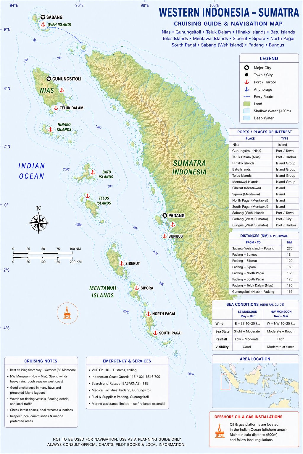
Chart Disclaimer. This chart is a schematic representation for illustrative purposes only and must not be used for navigation. Refer to official hydrographic charts for safe navigation. Be aware ENC charts may differ from official hydrographic charts. Both should be corrected and updated regularly.
Oil Rig Navigation Warning
Navigation around Indonesian offshore oil and gas installations is governed by a combination of international maritime law (primarily UNCLOS and IMO guidance) and Indonesian national regulations, and these impose strict safety, clearance, and reporting requirements that are critical for cruising yachts to understand.
The most important rule is the establishment of a mandatory safety (exclusion) zone around offshore platforms. Under United Nations Convention on the Law of the Sea, coastal states such as Indonesia are entitled to create a 500-metre safety zone measured from the outer edge of the installation, within which navigation is restricted and vessels must not enter unless authorised. In practice, many installations also have wider precautionary areas (often charted or advised in Notices to Mariners) where vessels are expected to proceed with extreme caution. From a practical navigation standpoint for yachts:
- Maintain a minimum 500 m clearance or greater at all times (treated as “no-go” zone).
- Expect guard vessels around rigs; these may call you on VHF and direct your course.
- Platforms are well lit at night and marked on charts, but subsea infrastructure (pipelines, wellheads) may extend well beyond the visible structure.
- Anchoring, fishing, or drifting near installations is strictly prohibited due to risk of damage and liability.
In Indonesian waters particularly areas such as the Java Sea, Natuna Sea, and Makassar Strait dense oil and gas infrastructure means that route planning must account for clusters of platforms, not just isolated rigs. For cruising yachts, the real-world implications are:
- Treat oil fields as hazard zones, not just chart features
- Avoid night transits through dense fields where possible
- Use up-to-date electronic charts (ENC) and Notices to Mariners
- Keep a continuous watch and radar guard zones, and AIS active when transiting near installations
Western Indonesia Sumatra Sailing Routes - Ports
Routes through Western Indonesia Sumatra move from the northern entrance at Sabang (Weh Island) down the exposed Indian Ocean coastline toward Sibolga, then continue south toward the offshore island groups of Nias, linking the main town of Gunungsitoli and the southern access at Teluk Dalam, before extending westward to the Hinako Islands, Batu Islands, and the elongated chain of the Telos Islands. Further south, movements enter the Mentawai Islands, connecting Siberut, Sipora, North Pagai, and South Pagai, before reaching the mainland access at Padang and the sheltered anchorage at Bungus. Together, these ports and island settlements form the operational chain that defines movement through the Western Indonesia Sumatra region
Western Indonesia
Sumatra Sailing Routes - Weather
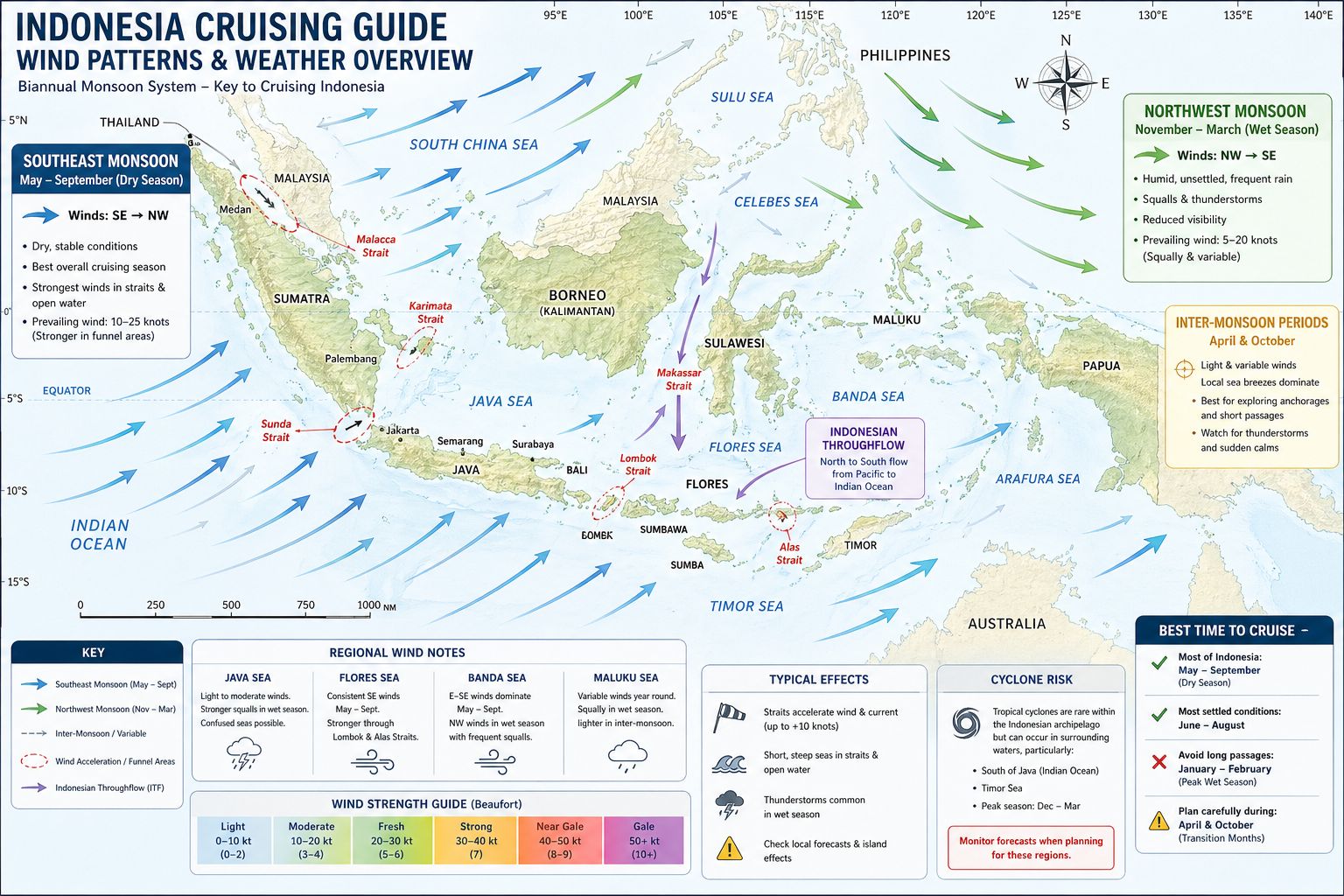
Weather across Western Indonesia Sumatra is shaped by the monsoon cycle, with the northwest monsoon bringing heavier rain, reduced visibility, and variable winds from December to March, while the southeast monsoon provides more stable conditions with moderate, drier airflow from June to September. The Indian Ocean swell influences the entire coastline year‑round, with heavier surf during the monsoon transition periods. Localised convection over the offshore islands produces sudden squalls and rapid cloud build‑up, especially near Siberut and Sipora. Rainfall is frequent throughout the year, with humidity and heat shaping daily conditions along the coast.
Western Indonesia
Sumatra Sailing Routes - Navigation
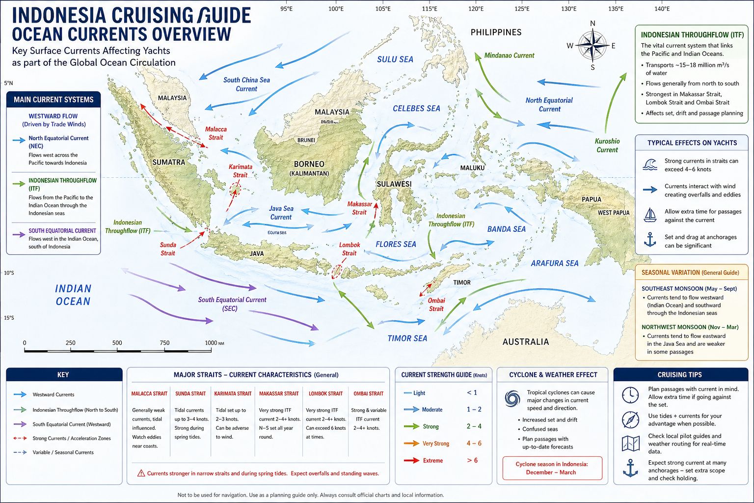
Navigation relies on depth, light, and visual reef reading, as charts are incomplete and local conditions vary. Volcanic islands drop steeply into deep water, while coral shelves create narrow anchoring zones with limited swing room. Surf breaks dominate many coastal approaches, making entry unsafe except in calm conditions. Offshore islands such as the Hinako, Batu, and Telos groups have unmarked hazards, shallow reefs, and limited protection from swell. Fishing fleets operate close to shore, deploying nets, traps, and unlit markers that complicate night movement. Few navigation aids exist outside major commercial ports, and even marked channels may shift after seasonal changes.
Chart Accuracy Western Indonesia and Sumatra
- Official Hydrographic Charts (Indonesian Navy – Pushidrosal). Accuracy level: LOW to MODERATE depending on the sub‑region. Most charts for Nias, Hinako, Batu, Telos, Mentawai, Pagai, Enggano are based on pre‑1970s lead‑line surveys. Depths are approximate, not modern multibeam. Reef edges are generalised, not precise. Many anchorages show no soundings or single‑point soundings only. LAT (Lowest Astronomical Tide) datum is not consistently applied across older sheets. Where accuracy improves: Sabang (Weh Island) modern survey, good accuracy. Padang & Bungus moderate accuracy in commercial approaches. Sibolga fair accuracy in the main harbour only. Where accuracy collapses: Hinako Islands, Batu Islands, Telos Islands, Mentawai chain (Siberut, Sipora, Pagai). Remote bays and reef systems. These areas require visual navigation, drone recon, and satellite‑based reef reading.
- Navionics (SonarChart + Government ENC Blend): Accuracy level: MODERATE in commercial zones, LOW in offshore islands. Good for general coastline shape. Good for major approaches (Sabang, Padang, Sibolga). SonarChart layer sometimes shows user‑generated depth contours in popular surf anchorages. Weaknesses include reef edges in Mentawai, Telos, Batu, Hinako are offset by 20–150 m. Depth contours are interpolated, not surveyed. Many shoals are missing. Some islands are mis‑shaped or shifted slightly. Operational rule. Use Navionics for macro routing, never for micro pilotage.
- C‑Map (NT+ / Reveal / 4D). Accuracy level: MODERATE in shipping areas, LOW in remote islands. Better contour smoothing than Navionics. Good depiction of major channels and commercial approaches. Slightly more accurate around Sabang and Padang. Weaknesses include reef edges in Mentawai, Telos, Batu are incomplete. Some anchorages show blank areas with no detail. Depths often copied from old Indonesian charts. Operational rule: C‑Map is no more accurate than Navionics in the offshore island groups.
- Garmin BlueChart. Accuracy level: LOW to MODERATE. Garmin uses a blend of Old Indonesian hydrographic data. C‑Map sources. Satellite‑derived coastline vectors. Operational notes: Good for coastline shape. Poor for reef detail. Depths are not reliable in Mentawai, Telos, Batu, Hinako.
- Satellite‑Derived Navigation (Google / Bing / SASPlanet / ESRI). Accuracy level: HIGH for reef edges, LOW for depth. Best method for reef reading in Mentawai, Telos, Batu, Hinako. Reef edges visible to within 3–10 m accuracy. Ideal for anchorage selection and approach planning. Weaknesses include no depth information. Cloud cover can obscure detail. Requires visual confirmation on arrival. Operational rule. Satellite imagery is mandatory for safe entry into remote anchorages.
- Operational Summary. Official Indonesian charts: old, generalised, inconsistent. Navionics: good for routing, unreliable for reef edges. C‑Map: similar limitations, slightly better smoothing. Garmin: coastline OK, depths unreliable. Satellite imagery: essential for reef navigation. Drone recon: highly recommended in Mentawai, Telos, Batu, Hinako. Skipper‑grade rule for this region. Use paper/ENC charts for macro routing, Navionics/C‑Map for cross‑checking, and satellite imagery for every anchorage approach.
Western Indonesia
Sumatra Sailing Routes - Provisioning
Provisioning varies widely across Western Indonesia Sumatra. Larger towns such as Sabang, Gunungsitoli, and Padang offer basic supermarkets, markets, and dry‑goods suppliers, though availability fluctuates with shipping schedules and local demand. Smaller island settlements provide only local produce, rice, and limited packaged goods. Fresh vegetables and fruit are available intermittently, while dairy, meat, and imported goods are inconsistent. No location in the region offers yacht‑grade water, fuel, or technical services, and all major provisioning must be completed before entering the region or at the few larger towns with modest supply chains. Yachts must remain self‑sufficient for extended periods.
Western Indonesia
Sumatra Sailing Routes - Cuisine
Cuisine across Western Indonesia Sumatra reflects coastal communities, fishing traditions, and regional variations between the offshore islands and the mainland. Fish, grilled or fried, forms the core of daily meals, accompanied by rice, cassava, or sago depending on the island group. Markets offer simple prepared foods, dried fish, and local vegetables, with limited variation outside the larger towns. Inland areas rely more on root crops and preserved fish, while coastal towns incorporate dried fish and rice. Crews will encounter straightforward, locally sourced meals rather than complex regional cuisine
Indonesian
Beverages
Indonesia offers a varied but locally distinctive range of beverages shaped by culture, climate, and religion. Beer is the most widely available alcoholic drink, with Bintang and Anker Beer being the most common, typically light, refreshing lagers suited to the tropical heat. In some regions, traditional spirits are produced, such as Arak Bali, a strong distilled liquor often made from palm sap or rice, and Tuak, a fermented palm wine found in various islands. Availability of alcohol varies significantly, with stricter limitations in more conservative areas. Non-alcoholic beverages are a major part of daily life, including fresh tropical juices (jus buah), young coconut water (air kelapa), and sweet iced teas. Indonesian coffee is also notable, with varieties such as Kopi Tubruk widely consumed, alongside the globally known Kopi Luwak. Herbal drinks known as jamu, made from turmeric, ginger, and other roots, are traditionally valued for their health benefits and are commonly found in local markets.
Mechanical
and Electrical Repairs Resource
If you are headed somewhere remote consider the need to expand your knowledge base or have an information resource on board. Why not get a copy of my book The Marine and Electrical and Electronics Bible 4th Edition. By and for yachties, with everything from batteries and charging, solar and wind, diesel engines and marine electronics and so much more. Your complete systems guide. 650 pages of practical advice. In Australia and New Zealand order a copy through Boat Books. UK and European boats can buy the UK Edition Here. US and Canadian boats can get the US Edition Order Here or through Amazon. Marine systems are my profession so let me help you. By a liveaboard boat owner for other boat owners.


Western Indonesia
Sumatra Sailing Routes - Summary
Western Indonesia Sumatra is an exposed, ocean‑influenced cruising region defined by surf‑affected approaches, deep basins, and limited infrastructure. Movement depends on seasonal weather, visual navigation, and careful planning due to the absence of yacht‑grade services. Ports and villages provide only basic supplies, and yachts must plan for minimal shore support throughout the region. Western Indonesia Sumatra Sailing Routes for all you need to know.