Port Elizabeth Yacht
Cruising Guide
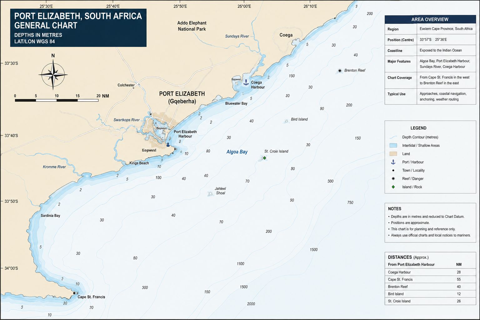
Port Elizabeth Yacht Cruising Guide. Port Elizabeth, officially Gqeberha, occupies the western side of Algoa Bay on South Africa’s Eastern Cape coast. The port remains identified in harbour documentation as the Port of Port Elizabeth. The position places it between the Agulhas Current route offshore and the south-coast passage around Cape Recife. The city developed around cargo handling, rail links, fishing, vehicle exports and harbour engineering. A yacht using the port enters an industrial operating area governed by national port rules.
Algoa Bay is open to Indian Ocean swell and wind-generated sea from the eastern sector. Cape Recife defines the southwest limit of the bay, while the Port of Ngqura lies across the bay to the northeast. The coastline includes sand beaches, reef, rocky points, river mouths and commercial port works. Offshore passage conditions change when wind direction reverses against the Agulhas Current or shelf flow. Port Elizabeth functions as a weather-bound coastal stop within a commercial harbour system.
Port Elizabeth Yacht Cruising Guide - History
Bartolomeu Dias entered Algoa Bay in 1488 during the Portuguese exploration of the sea route around southern Africa. European settlement expanded after British forces established Fort Frederick above the Baakens River mouth in 1799. The fort controlled the landing place and protected the anchorage against a seaborne attack. The town of Port Elizabeth was founded in 1820 after the arrival of British settlers. Ships remained in the open roadstead while passengers and cargo were transferred through the surf by lighters, surfboats and landing baskets.
The first harbour works began during the nineteenth century, but sand movement and Baakens River flooding damaged early breakwater schemes. North Jetty and Dom Pedro Jetty supported lighterage before construction of the enclosed harbour. Charl Malan Quay opened on 28 October 1933 and marked the transfer from open-roadstead cargo handling to alongside berthing. Maritime heritage surveys have identified records for more than 300 wrecks in Algoa Bay, including nineteenth-century losses around Cape Recife, Roman Rock and the former roadstead. Submerged prehistoric material can also occur in buried river channels beneath the bay, and wreck material more than 60 years old is protected under South African heritage law.
Port Elizabeth Yacht
Cruising Guide - Approaches
From the west, remain clear of Cape Recife, Thunderbolt Reef, Roman Rock and the reef extending from the cape. The Cape Recife Lighthouse marks the southern limit of Algoa Bay, but it does not mark the edge of every isolated danger. Water outside the coastal reef system is generally 20–40 m deep before deepening farther offshore. Do not cut inside the charted dangers to reduce distance. Round Cape Recife with enough clearance for position error, swell set and wind-driven current, then alter north toward the Port Elizabeth entrance.
From the east or northeast, keep clear of shipping routes serving both Port Elizabeth and Ngqura. Algoa Bay contains ship anchorages, pilot boarding areas, fishing traffic and vessels manoeuvring at reduced speed. Approach depths across the western bay generally exceed 20 m until the harbour works are reached. Anchored ships cannot be used as fixed waypoints because they swing and can be moved under port orders. Identify the Port Elizabeth breakwater and harbour entrance before closing the commercial approach.
Port Elizabeth Yacht Cruising Guide - Navigation
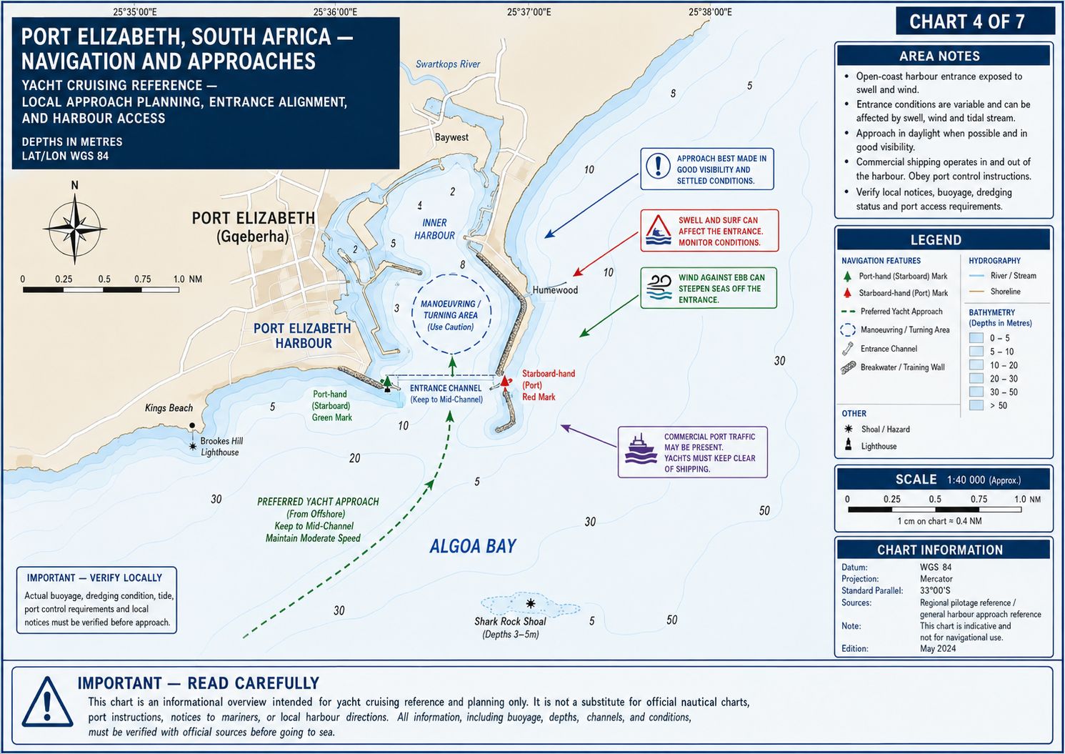
The harbour entrance is approximately 300 m wide, with a published entrance-channel depth of 14.5 m. Call Port Elizabeth Port Control, call sign ZSC, on VHF Channel 12 before entering port limits. State the yacht name, position, length, draught, persons aboard and requested movement. Remain outside until Port Control grants permission. Commercial ships, tugs, pilot boats and fishing vessels have priority, and a yacht must remain clear of their approach and turning areas.
Enter under power through the marked channel and maintain the route allocated by Port Control. Do not cross ahead of an inbound or outbound ship and do not stop between the breakwater heads. Port traffic signals and radio instructions remain controlling even when the channel appears clear. The harbour basin contains commercial quays, tanker facilities, fishing-vessel berths, tug stations and restricted operating areas. Continue on the charted route until released from the immediate entrance movement by Port Control.
Port Elizabeth Yacht Cruising Guide - Lights and Lighthouses
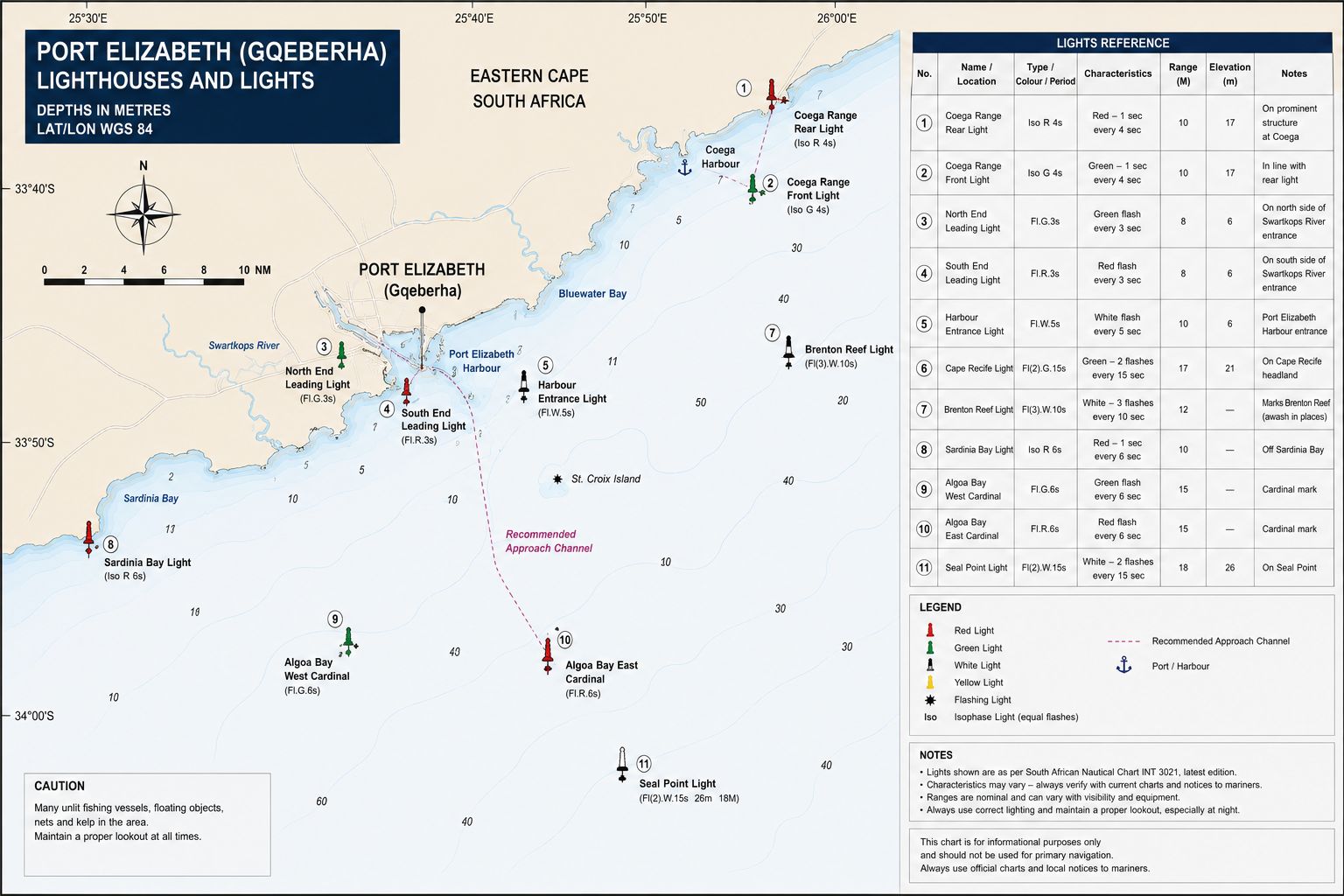
- Cape Recife Lighthouse stands at the southwest limit of Algoa Bay near 34°01.7′S 025°42.0′E. The structure is a 24 m octagonal masonry tower marked with black and white horizontal bands. It was first lit on 1 April 1851. The focal plane is approximately 28 m above sea level, with a nominal range of about 29 nautical miles. Thunderbolt Reef and Roman Rock lie offshore from the cape, so the lighthouse must not be used as a waypoint for a close rounding.
- Port Elizabeth Breakwater Light stands at the seaward end of the main breakwater. The structure has a focal height of approximately 16 m and displays two quick red flashes. Use the current charted characteristic because maintenance work and temporary light changes can occur.
- Port Elizabeth Leading Light is positioned inside the harbour area and provides a directional sector for the entrance alignment. The light displays white, red and green sectors, with the white sector defining the required approach alignment. Do not continue on a red or green sector unless directed by Port Control.
- Roman Rock Bell Buoy marks Roman Rock north of Cape Recife. It is an east cardinal mark, requiring passage to the east of the buoy. Its white light uses the east-cardinal group of three quick or very quick flashes. The buoy also carries an audible bell signal. Confirm its charted position before approach because it is a floating aid rather than a fixed structure.
- The harbour contains additional lateral marks, quay lights and operational navigation lights. Use only the current SANHO chart and List of Lights for characteristics and positions. Port working lights can obscure navigational lights when viewed against the city background.
Port Elizabeth Yacht Cruising Guide - Chart Accuracy
Use the current SANHO large-scale chart for the Port of Port Elizabeth and the current chart covering Algoa Bay and Cape Recife. Apply South African Notices to Mariners before arrival. Electronic chart updates supplied by a plotter manufacturer do not confirm that every SANHO correction has been incorporated. Check the edition date, update number, temporary notices and current status of lights and buoys.
GPS positioning is reliable in open water, but displayed chart accuracy does not remove survey limitations around reefs, harbour margins and marina berths. Maintain a position cross-check using radar ranges, visual bearings, depth sounder information and AIS traffic. Do not navigate between Cape Recife dangers by relying on a small-scale electronic chart. Marina depths are berth-specific and cannot be established from the commercial harbour dredging depth.
Port Elizabeth Yacht Cruising Guide - Currents and Tidal Flows
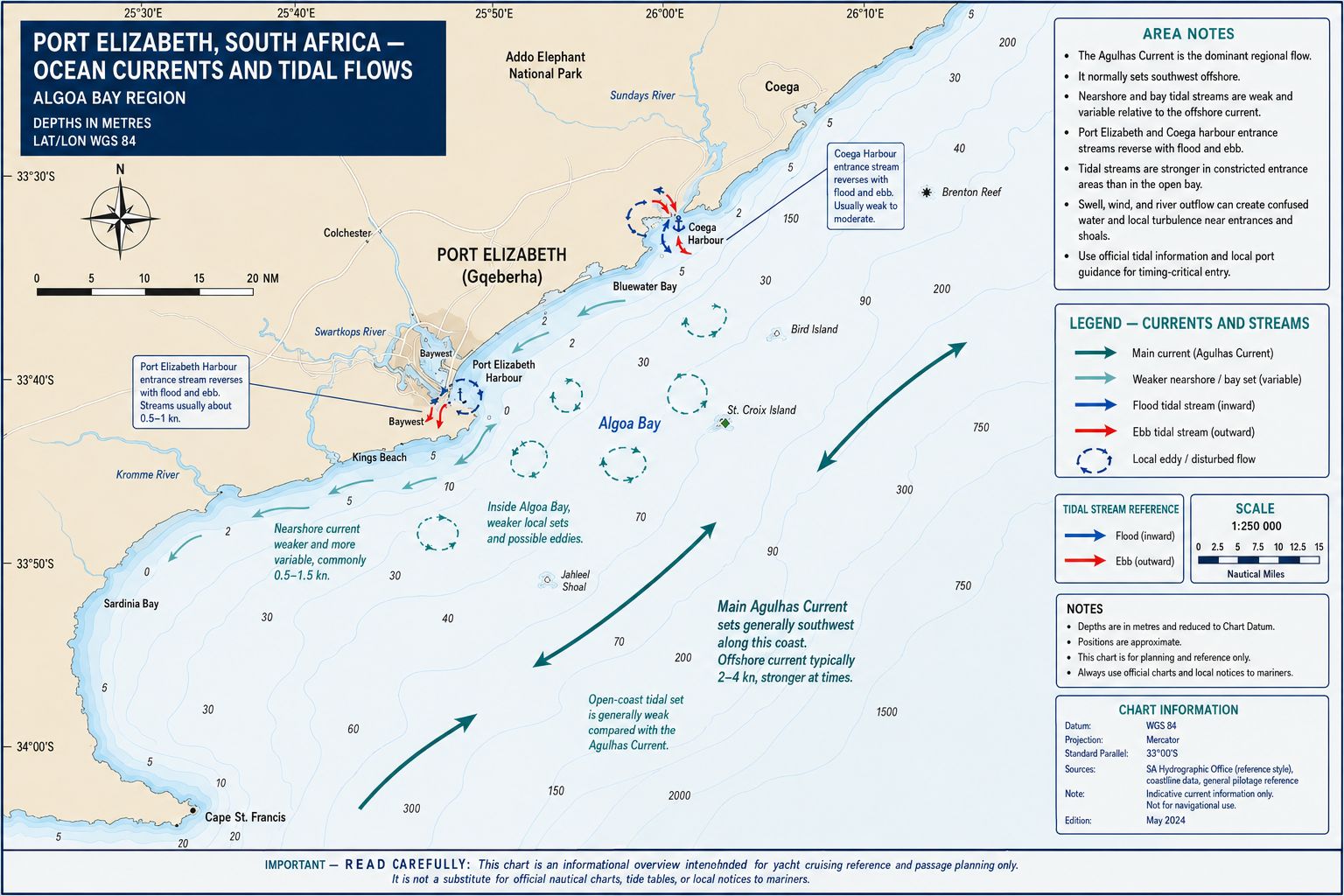
The Agulhas Current flows southwest beyond the continental shelf and normally reaches its main velocity band about 25–35 nautical miles offshore from Port Elizabeth. The current position changes with meanders, eddies and shelf interaction. Do not apply an offshore Agulhas Current forecast directly to the western part of Algoa Bay. Nearshore flow is weaker and is controlled by wind, tide, coastal geometry and water movement around Cape Recife. Compare speed through the water with speed over the ground before selecting an inshore or offshore passage track.
Port Elizabeth has a semidiurnal tide with two high waters and two low waters during most lunar days. The spring tidal range remains below 2 m, but the change is sufficient to affect under-keel clearance at marina berths and shallow harbour margins. Wind can raise or lower the observed water level relative to the predicted tide. Easterly winds tend to drive water into the western bay, while sustained westerly and southwesterly winds can alter shelf flow and reduce water levels near the coast. Tidal streams at the harbour entrance are normally limited, but wind-driven flow and discharge from the Baakens River can produce a cross-set after rain.
Port Elizabeth Yacht
Cruising Guide - Anchorage
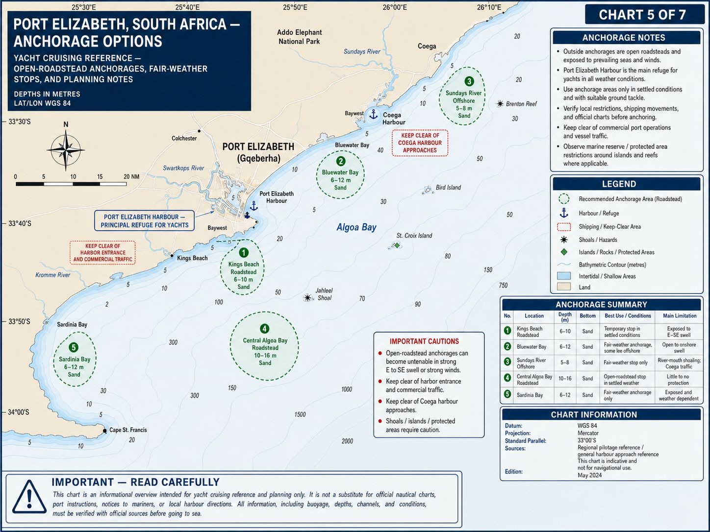
There is no unrestricted yacht anchorage inside the Port of Port Elizabeth. Anchoring within the harbour requires Port Control authority because the basin contains commercial manoeuvring areas, cables, berth approaches and port equipment. A yacht waiting for a berth must use the position allocated by the marina or Port Control rather than selecting an open area of the basin.
The port-assigned Algoa Bay roadstead lies outside the harbour entrance in charted depths generally between 15 and 25 m. The seabed consists mainly of sand and mud, with holding dependent on the allocated position and anchor penetration. This anchorage is exposed to easterly, southeasterly and southerly wind and swell. Northeasterly wind creates fetch across the bay, while southwest changes can produce a rapid wind shift and increased sea state. Use the roadstead only when Port Control assigns a position and the yacht can clear the shipping approach.
The Swartkops River and Redhouse Yacht Club are not viable anchorage alternatives for an offshore cruising yacht. The river mouth is shallow, affected by breaking seas and unsuitable for a keel yacht of normal cruising draught. Do not attempt entry from Algoa Bay.
Port Elizabeth Yacht
Cruising Guide - Entry
Formalities
Port Elizabeth is a South African port of entry and departure for foreign yachts. An international arrival requires pre-arrival registration, Port Control notification, health pratique, Immigration clearance, Customs clearance and temporary import documentation for the yacht. Complete the South African yacht arrival process before reaching the port and carry the issued authorisation aboard. Crew must remain aboard until landing permission has been granted.
Each crew member completes the required Customs traveller declaration for cash and goods. The yacht is declared separately on the applicable SARS temporary import form. Foreign-registered yachts are normally admitted temporarily for up to six months unless Customs approves an extension. Passports, visas where required, vessel registration, crew list, last-port clearance and proof of ownership must be available for inspection. A domestic coastal passage plan and departure approval are required before sailing to another South African port.
Biosecurity officers can inspect food, plants, animal products, waste and animals aboard. Declare all controlled items. A pet arriving at a port that lacks the required veterinary clearance arrangements can be confined aboard pending instructions. Do not land food waste or animal products until disposal has been authorised.
Starlink does not hold a South African operating licence at the time of writing. Do not operate Starlink equipment within South African jurisdiction unless current licensing status confirms legal service. Private drone use remains subject to South African Civil Aviation Authority rules, visual-line-of-sight limits, property permission and controlled-airspace restrictions. The harbour lies beside Gqeberha Airport and within a controlled port; do not launch a drone from the marina or harbour without written port and aviation approval.
Port Elizabeth Yacht
Cruising Guide - Marina
Facilities
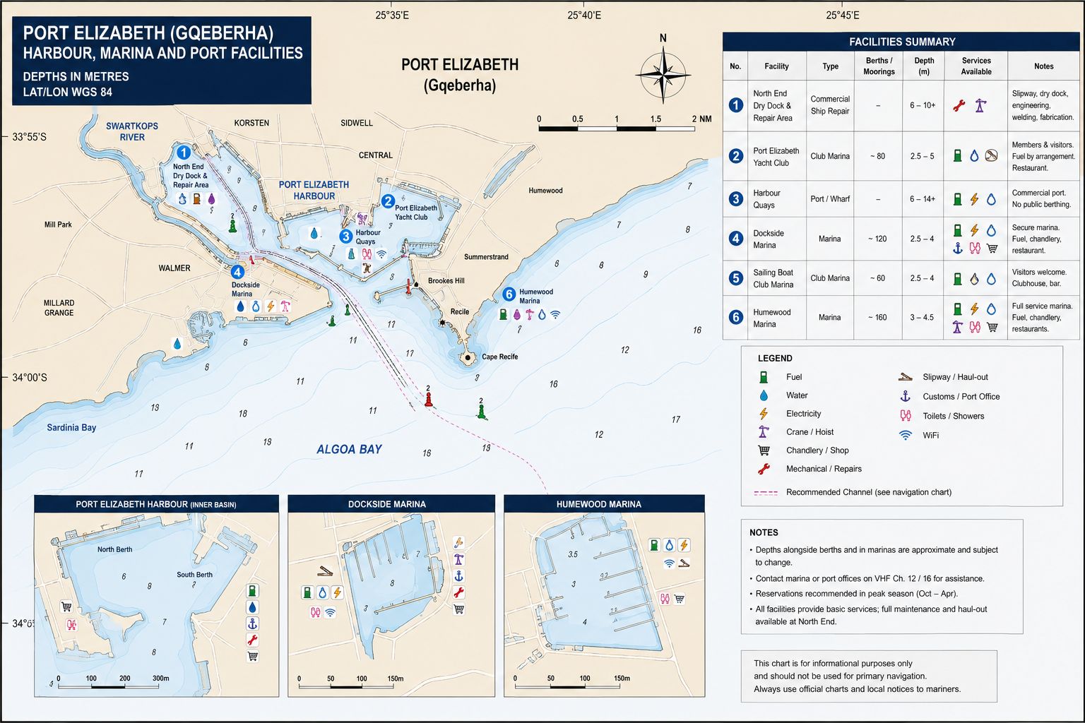
Algoa Bay Sailing Marina occupies the southwest part of the commercial harbour near Dom Pedro Jetty. The former Algoa Bay Yacht Club shore facility is closed, but the marina remains in use under local sailing administration. Berths are allocated rather than taken on arrival. Contact the marina before entry and obtain the berth number, approach route and controlling depth.
The waiting position has a published draught limit of approximately 3.0 m. Some internal berths carry about 2.0 m at low water, with actual depth dependent on berth position, silting and tide. Confirm the assigned berth depth against the yacht’s draught. Empty berths are privately allocated and cannot be occupied without authority.
The marina uses concrete pontoons with steel edge framing about 0.2–0.3 m above water level. Place fenders low enough to prevent the hull contacting the steel frame. Access from shore is controlled through the port gate and pontoon security system. Crew and contractors require the access arrangement issued by the marina or port security.
Electricity is available at parts of the marina. Confirm outlet location, voltage, current rating and connection type before use. Permanent water is not available on all yacht pontoons, and water delivery requires arrangement. The closed yacht-club building means that toilets, showers, laundry and club facilities cannot be assumed. No routine yacht haul-out facility is confirmed within the marina. Ngqura has no recreational yacht berthing, and Redhouse is not accessible to an offshore keel yacht.
Port Elizabeth Yacht
Cruising Guide - Local Weather
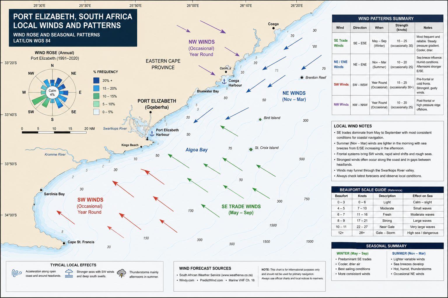
Port Elizabeth has a frontal weather cycle dominated by alternating eastern-sector and western-sector systems. Summer conditions include easterly and northeasterly winds, afternoon cloud development and periods of coastal upwelling. Winter brings a higher frequency of westerly and southwesterly winds associated with cold fronts crossing the south coast. Rain occurs throughout the year rather than within one defined wet season. Visibility can be reduced by rain, sea spray, low cloud, haze and manganese dust moving from the port stockpiles.
The harbour provides wave shelter after entry, but weather outside Cape Recife can differ from conditions at the berth. A southwest change can reach the cape before its full force is apparent inside the harbour. Wind against an opposing current produces reduced wave spacing and increased wave face. Easterly wind generates fetch across Algoa Bay and can produce a short sea between the port and Cape Recife. Use the coastal forecast, offshore wave model, barometric trend and observed sea state together; a harbour wind reading alone does not describe the passage conditions.
Port Elizabeth Yacht Cruising Guide - Local Winds
Easterly and northeasterly winds occur most often from spring through summer. These winds cross Algoa Bay toward Port Elizabeth and produce wave development across the width of the bay. Sustained northeast flow causes upwelling along the western side of Algoa Bay, reducing sea temperature and increasing local current variation. Easterly wind also carries manganese ore dust from the commercial handling area toward the yacht berths. A vessel berthed during an easterly period requires closed hatches and protected deck equipment.
Westerly and southwesterly winds occur throughout the year and are more frequent during winter frontal passages. A southwest change can arrive with a pressure rise, temperature fall and rapid increase in wind speed. Strong southwest wind can reverse nearshore current direction and create east-going shelf flow around Cape Recife..
Port Elizabeth Yacht
Cruising Guide - Provisioning
Supermarkets. Waterfront SUPERSPAR, Checkers Greenacres, Pick n Pay Hyper Greenacres, Woolworths Food Greenacres and Food Lover’s Market Walmer are the main provisioning outlets within road reach of the harbour. Waterfront SUPERSPAR at Humerail lies about 3 km from the marina and operates from 07:00 to 20:00 daily. Greenacres Shopping Centre lies about 6–7 km by road and contains Checkers, Pick n Pay Hyper and Woolworths Food. Walmer outlets lie about 7–9 km from the marina. Port gate control prevents direct pedestrian movement through parts of the harbour, so vehicle access is required for bulk loads.
Markets. Nelson Mandela Bay Municipality Fresh Produce Market operates in the Motherwell area about 20 km from the harbour. Public trading operates Monday to Friday from 06:00 to 10:30. The market handles regional vegetables, fruit, potatoes, onions, citrus and seasonal Eastern Cape produce. Market in the Park operates at St George’s Park on selected Sundays, normally from 09:00 to 14:00. The site lies about 5 km from the harbour. Operating dates change through the year and must be checked against the current market calendar. Crossways Village Market operates at Crossways Farm Village on announced market dates, normally from 09:00 to 14:00. It lies about 40 km by road from the port. Produce includes farm vegetables, preserves, bread, meat and products from farms west of Gqeberha.
Fish Markets. Fisherman Fresh Deli operates inside the Port Elizabeth harbour area and sells fish landed through the port. Access depends on port gate controls and current trading hours. Fresh Fish on Circular in Walmer and Seven Seas Fisheries provide shore alternatives outside the harbour.
Common local and regional fish include Cape hake; geelbek, also called Cape salmon; kob or kabeljou, meaning dusky kob; snoek, meaning Cape snoek; yellowtail; carpenter; kingklip; tuna; sole; red roman; maasbanker, meaning horse mackerel; and pilchard. Availability changes with season, quota, sea state and landings.
Port Elizabeth Yacht
Cruising Guide - Local Cuisine
Eastern Cape cooking includes isiXhosa dishes based on maize, beans, pumpkin, cultivated greens and meat. Umngqusho is samp cooked with sugar beans. Umleqwa is mature free-range chicken cooked until tender and commonly served with umngqusho. Umpoqhoko is dry, crumbed maize meal served with amasi, which is cultured sour milk. Isopho is a maize-based soup, while imithwane and ilaxa use pumpkin leaves and pumpkin.
Port Elizabeth coastal food includes fried or grilled hake, snoek, calamari, mussels, prawns, yellowtail and line fish. Fish and chips normally uses hake. Geelbek and kob are prepared as grilled steaks, baked portions or curries. Cape Malay spice methods, Afrikaans meat cookery and isiXhosa staple dishes are all present in the city’s food culture. Citrus, dairy products, lamb and farm produce enter the city from the wider Eastern Cape.
Port Elizabeth Yacht Cruising Guide - Beverages
Dockside Brewery operates in Gqeberha and produces cream ale, pale ale and seasonal beer. Richmond Hill Brewing Company and Bridge Street Brewery operate in the Baakens Valley area and produce lager, pilsner, ale and stout. South African commercial lagers remain the most common packaged beers supplied through supermarkets and bottle stores. Mageu is a non-alcoholic fermented maize drink used across the Eastern Cape. Amasi is consumed as cultured milk and with maize dishes. South African brandy, cane spirit, gin and wine are available through licensed outlets.
Port Elizabeth Yacht
Cruising Guide - Fuel Supplies
There is no confirmed dedicated diesel fuel pontoon for cruising yachts at Algoa Bay Sailing Marina. Diesel is obtained through an approved road delivery, commercial bunker arrangement or portable containers brought through the controlled port gate. Obtain marina and port approval before arranging a tanker or carrying fuel containers onto the pontoons.
Use automotive or marine diesel supplied through a registered fuel distributor. Confirm the grade, sulphur specification, delivery quantity and invoice before transfer. Filter fuel transferred from portable containers and prevent water or manganese dust entering the deck filler.
Port Elizabeth Yacht
Cruising Guide - Water Supplies
Fresh water is available at commercial port berths on request, but this does not establish permanent water availability at the yacht marina. Marina water requires prior arrangement with the local marina contact or port authority. Do not arrive with the vessel’s tanks dependent on immediate pontoon access.
Municipal water is treated for potable use, but local supply interruptions and pressure restrictions can occur. Confirm that the supply point is connected to the potable system before filling tanks. Use the yacht’s own hose and prevent the hose end contacting harbour water or the pontoon surface. Water delivered by tanker requires confirmation of the tanker’s potable-water certification.
Mechanical and Electrical Repairs
Resource
Why not get a copy of my book The Marine and Electrical and Electronics Bible 4th Edition. In Australia and New Zealand order a copy through Boat Books. UK and European boats can buy the UK Edition Here. US and Canadian boats can get the US Edition Order Here. Marine systems are my profession so let me help you. In South Africa you can buy the book through Amazon or Loot.co.za or Kobo.co.za


Port Elizabeth Yacht
Cruising Guide - Marine
Services
Bay Way Marine and Bay Way Electronics operate from South End and the Port Elizabeth harbour area. The company provides marine electrical work, electronic repairs, radio surveys, equipment installation, software updates and servicing for Raymarine, Simrad, B&G, Garmin, Icom, ComNav, Koden and other marine-electronics brands. It also undertakes VHF, AIS, EPIRB and SART testing.
Ocean Engineering provides commercial ship repair, steel work, welding, mechanical work. Legacy Marine builds aluminium vessels and undertakes marine fabrication and electrical installation. No current authorised Gqeberha agent has been confirmed for Volvo Penta, Yanmar, Nanni, Vetus or Beta Marine yacht diesel engines. General diesel workshops exist in the city, but commercial vehicle capability does not establish marine-engine authorisation. Confirm access through port security before bringing any contractor to the yacht.
OSASA - South African Yacht
Assistance
The Ocean Sailing Association of Southern Africa (OSASA) came into being during the COVID pandemic crisis where they actively assisted entry to South Africa by cruising yachts into its various ports. It is a non-profit company created to liaise with Maritime officials to facilitate entry to South African ports at the time. OSASA was assigned by the SA Department of Transport to handle the mandatory pre-arrival authorisation (PAN) for all incoming non-SOLAS yachts, both local and foreign. OSASA services include the following:
- Manage and update the online registration portal for incoming non-SOLAS vessels
- Manage the pre-arrival authorisation (PAN) process with the Department of Transport for incoming small vessels at the Ports of Entry
- Provide up-to-date information for cruising yachts navigating South African ports and coastal waters
- Develop and maintain a good working relationship with SA maritime authorities and port officials, and with local offshore yacht clubs and marinas
- Work with local offshore clubs and marinas to develop and enhance their facilities
Cruising yacht visitors are encouraged to contact OSASA. They are a group of willing and like minded volunteers along the South African coastline and will assist with the needs of cruising yachts. This group is known as the OSASA Port Ambassadors and will assist cruising yachts with anything that may be required. Anything from entry procedures right down to directing you to the nearest dentist or barber and anything in-between. There is a published list on the OSASA website as well as on the Sail to South Africa WhatsApp group of the individual OSASA port Ambassadors. Ports and marinas that are covered are Richards Bay; Durban; East London; Port Elizabeth; Port St. Francis; Knysna; Mossel Bay; Gordon's Bay, False Bay YC (Simon's Town), Hout Bay, Saldanha Bay; Port Owen; Cape Town (V&A Waterfront and Royal Cape YC).
Port Elizabeth Yacht
Cruising Guide - Local Etiquette
Gqeberha is the official city name, while the harbour authority continues to use Port of Port Elizabeth in operational documentation. Use “Port Elizabeth Port Control” during radio communication and “Gqeberha” for city references. English, isiXhosa and Afrikaans are used throughout the city. Begin an in-person request with a greeting before moving to the transaction. The harbour is a controlled industrial and security area. Present identification when requested and follow the gate procedure issued for crew, visitors and contractors. Obtain permission before photographing port operations, commercial vessels, officials or security installations. Do not touch or remove wreck material, pottery, fittings or other archaeological objects found underwater or on the shore.
Port Elizabeth Yacht
Cruising Guide - Summary
Port Elizabeth provides an enclosed commercial harbour on the western side of Algoa Bay. Entry requires VHF contact with Port Control, clearance from shipping and use of the marked 14.5 m entrance channel. Yacht berthing is available at Algoa Bay Sailing Marina, but berth depth, water access and shore facilities require confirmation before arrival. Use this as the Port Elizabeth sailing cruising guide. Port Elizabeth Yacht Cruising Guide for all you need to know