East London Yacht Cruising
Guide
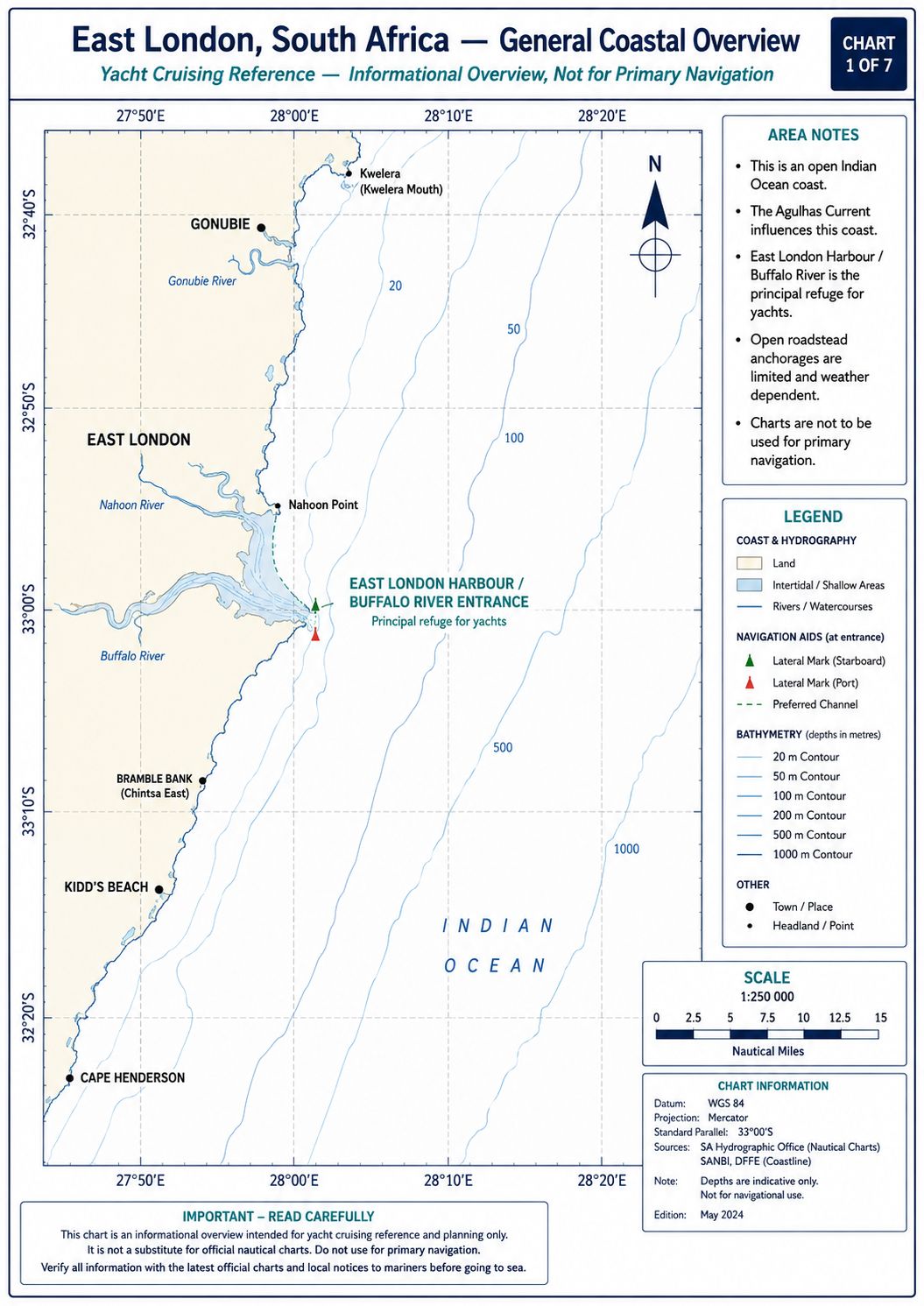
East London Yacht Cruising Guide. East London occupies the mouth of the Buffalo River on the Eastern Cape coast of South Africa. The Buffalo River cuts through the coastal plateau before entering the Indian Ocean between harbour breakwaters. The city developed around maritime trade, rail transport, fishing, vehicle manufacturing and cargo handling. Commercial activity remains concentrated along the river banks and within the controlled port boundary. Offshore routing is governed by the Agulhas Current, the continental shelf and the frontal weather cycle of the southeast coast.
The coast around East London consists of rock platforms, reefs, river mouths and sand beaches exposed to ocean swell. The Buffalo River estuary carries tidal water several kilometres inland and receives freshwater runoff from its catchment. The port handles vehicle carriers, bulk cargo, petroleum products, fishing vessels, tugs and service craft. The offshore current can run at several knots while the inshore flow follows a separate wind-driven pattern. Coastal weather can change within hours when a northeast flow is replaced by a southwest frontal wind. It is soem years since I visited this port but it is one I really enjoyed.
East London Yacht Cruising Guide - History
The Buffalo River mouth was surveyed by Royal Navy officer John Bailie in 1836 and the settlement established there was first known as Port Rex. Fort Glamorgan was constructed on the west bank in 1847 to protect the landing place and military supply route. Cargo was transferred between ships anchored offshore and small craft working through the river mouth before enclosed harbour works existed. Construction of the first breakwater began during the 1870s, followed by dredging, quay construction and river-bank development. The harbour became the transport outlet for the Border region and later supported rail freight, grain handling, petroleum storage and vehicle exports.
East London’s maritime archaeological record includes wrecks around Hood Point, Orient Beach, Nahoon Point and the approaches to the Buffalo River. The steamship Quanza was driven ashore east of Orient Beach in 1872 while carrying wool, and remains associated with the early roadstead period. Wreck material more than 60 years old is protected under South African heritage law and cannot be disturbed or removed without a permit. Nahoon Point contains a separate archaeological site where fossil human footprints were discovered in 1964 and dated to approximately 124,000 years before present. A preserved section of the footprint surface is held by the East London Museum.
East London Yacht Cruising
Guide - Approaches
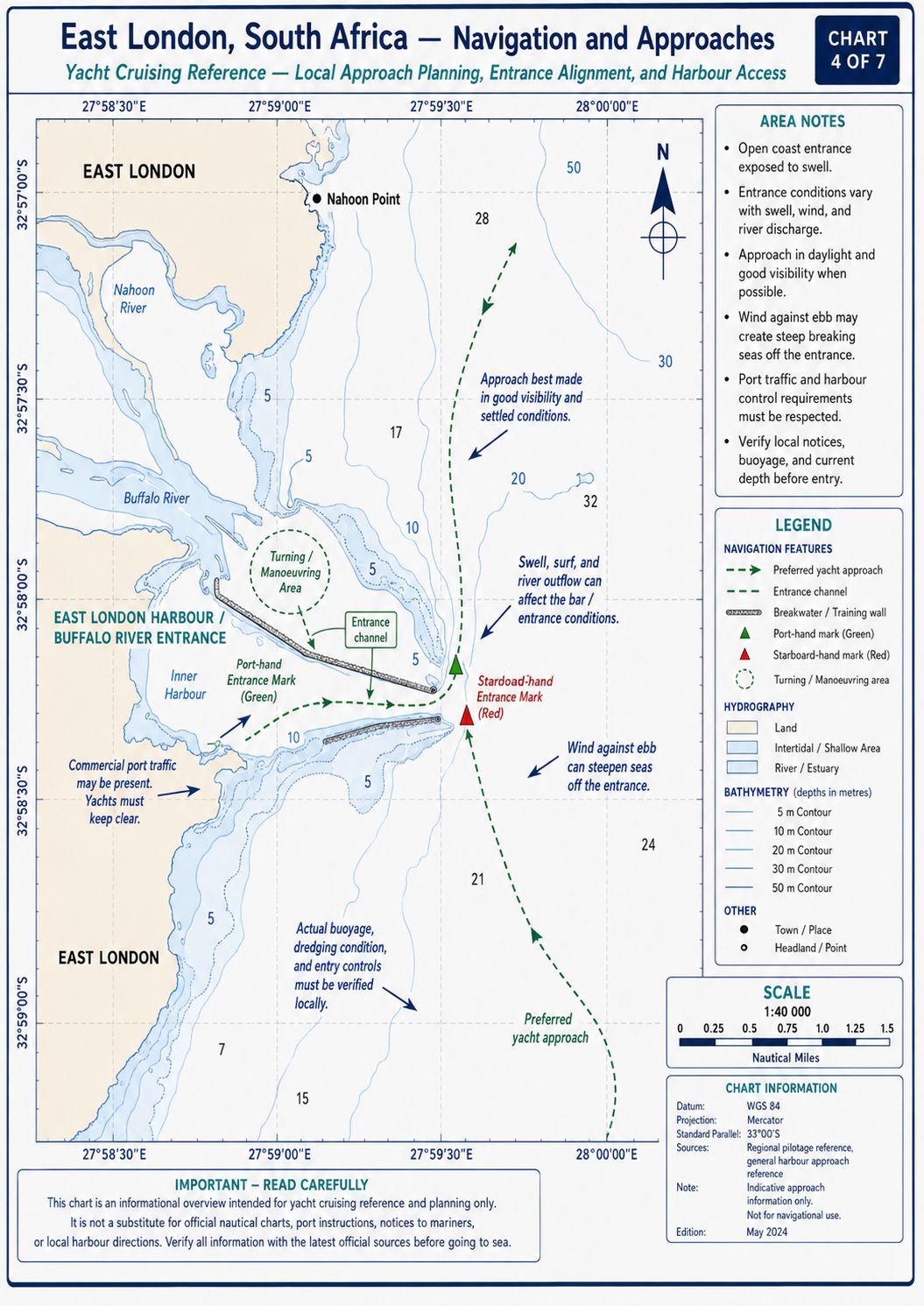
From the southwest, Hood Point provides the principal landfall reference before the Buffalo River entrance. Reefs and rock platforms extend from the coast between Hood Point and the harbour, and the inshore route cannot be treated as clear water. Depths outside the coastal reef zone are generally 20–40 m before decreasing toward the harbour works. Maintain clearance from the shore until the breakwater alignment and commercial traffic have been identified. South and southeast swell can break on the shallower coastal ground and produce reflected water outside the south breakwater.
From the northeast, approach outside the reef and surf zone extending from Nahoon Point. Nahoon Point Light is subject to a current unlit notice and cannot be used as a night landfall until that notice is cancelled. The coast north of the port contains rock shelves, sand beaches and the barred Nahoon River mouth. Do not use the Nahoon River entrance as a coastal shelter or route toward the harbour. Close the Buffalo River entrance on the charted seaward approach while remaining clear of ships, tugs and pilot craft.
East London Yacht Cruising Guide - Navigation
Call East London Port Control on VHF Channel 12 before reaching the breakwater entrance. State the yacht name, position, length, draught, number of persons aboard, last port and requested movement. Port Control is responsible for traffic through the entrance and along the commercial river channel. Remain outside until entry permission is issued. Commercial ships, tugs and port service vessels have priority and cannot manoeuvre outside the dredged channel.
The entrance channel has a maintained depth of approximately 12 m and carries commercial vessels drawing about 10 m. Enter on the Castle Point leading alignment and remain within the channel limits. The channel margins, breakwater sides and river edges are not yacht bypass routes. Inside the entrance, follow the movement instruction issued by Port Control and remain clear of turning basins, commercial berths and tug operating areas. Do not stop in the entrance, cross ahead of a ship or enter an unused commercial berth without port authority.
East London Yacht Cruising Guide - Chart Accuracy
Use SAN 1027, INT 7541, for the Port of East London and the current SANHO chart covering the coastal approaches. Apply all permanent, temporary and preliminary Notices to Mariners before arrival. Current notices include corrected port depths and the unlit status of Nahoon Point Light. A plotter update date does not establish that every SANHO correction has been incorporated into the electronic chart.
The commercial channel is dredged, but the river margins and yacht berthing area are affected by silt movement. Electronic chart contours cannot establish the present depth beside a pontoon or between local moorings. Cross-check the electronic position with the Castle Point range, breakwater lights, radar ranges and depth sounder. Do not use a small-scale approach chart for the final river transit.
East London Yacht Cruising Guide - Lights and Lighthouses
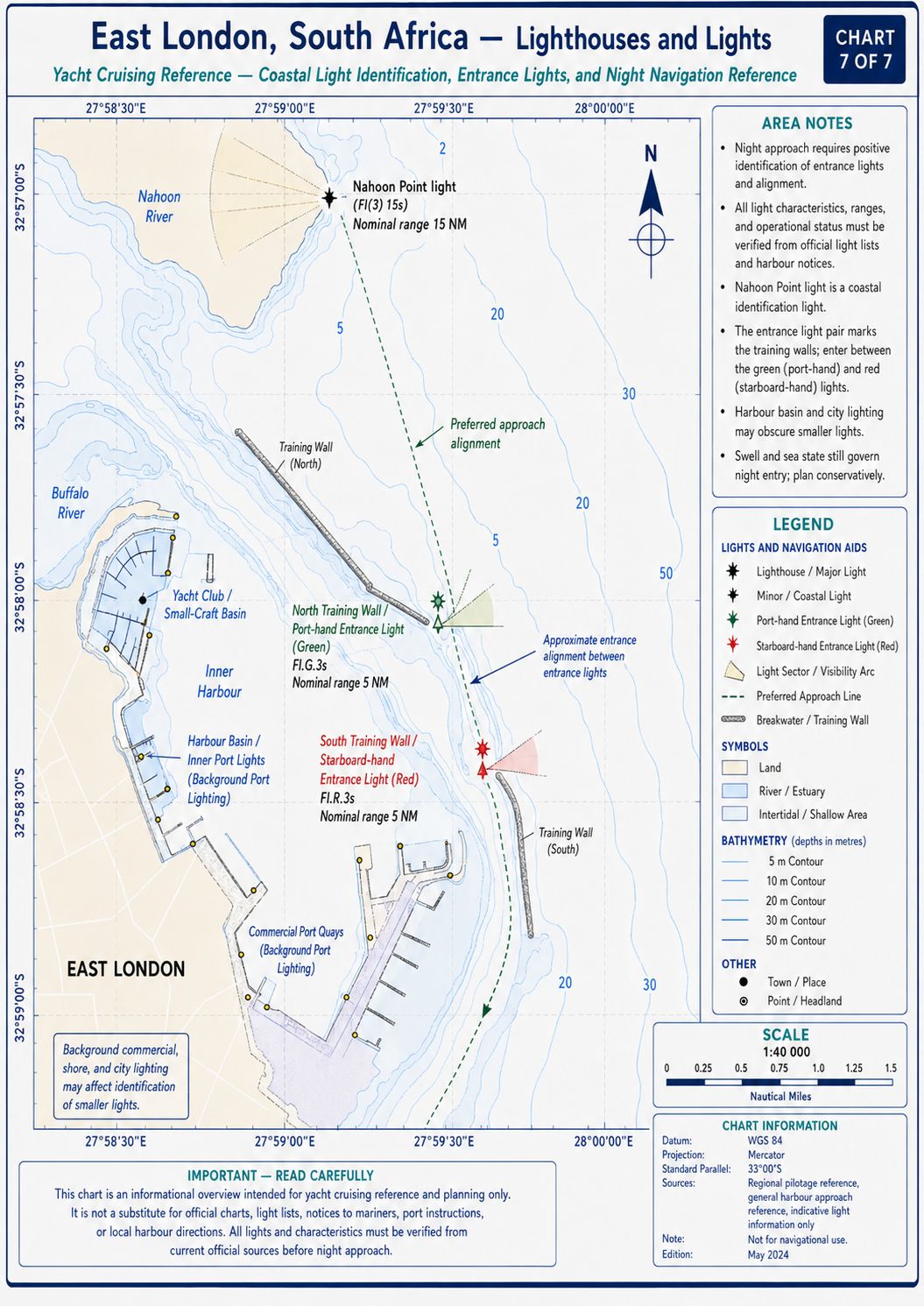
- Hood Point Lighthouse stands southwest of the Buffalo River entrance. The light was established in 1895 and has a focal plane of approximately 55 m. It displays a group of four white flashes every 40 seconds and has a nominal range of about 31 NM. The masonry tower is approximately 17 m high. Use Hood Point as a landfall reference rather than a close-coast waypoint because reefs and wreck sites lie off this section of coast.
- Nahoon Point Light stands northeast of the port at a focal plane of approximately 68 m. Its normal characteristic is one white flash every 3 seconds. The light is mounted above a concrete building marked by a red horizontal band. A current South African Notice to Mariners states that the light is unlit. Treat it as unavailable until the notice is formally cancelled.
- East Breakwater Light marks the eastern side of the entrance. It displays a quick-flashing green light from a focal plane of approximately 10 m. The structure is an 8 m white concrete tower. City and port lighting can reduce its visual separation from the background.
- South Breakwater Light marks the southern breakwater head. It displays one red flash every 2 seconds from a focal plane of approximately 16 m. The white concrete tower is about 13 m high. A fog signal gives four blasts, arranged as two long, one short and one long blast, every 30 seconds.
- South Breakwater Root Light displays a quick-flashing white light from a focal plane of approximately 10 m. The structure is a square white concrete tower about 7 m high. This light marks the inshore breakwater position and is not the seaward entrance light.
- Castle Point Leading Light Front displays a fixed red light from a focal plane of approximately 21 m. The mark is carried on a skeletal tower with a white triangular daymark pointing upward. It forms the front element of the entrance range.
- Castle Point Leading Light Rear displays an occulting white light every 3 seconds from a focal plane of approximately 60 m. The skeletal tower carries red and white bands and a white triangular daymark pointing downward. Align the rear light vertically above the front light when following the leading line, subject to Port Control instructions and the current chart.
East London Yacht Cruising Guide - Currents and Tidal Flows
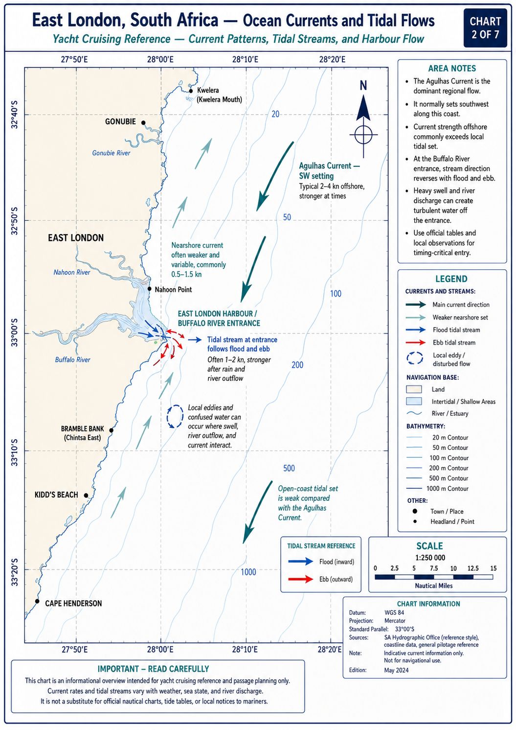
The Agulhas Current flows southwest along the continental shelf edge offshore from East London. Its core position changes, but the main stream normally lies well seaward of the harbour approach and can exceed 3 kn where the current is established. Inshore water can run southwest, remain weak or form a northeast countercurrent under local wind and shelf conditions. Do not calculate an East London arrival from a single offshore current value. Compare speed over the ground with speed through the water while crossing the shelf and alter the route from measured current rather than the forecast current axis alone.
The Buffalo River has a semidiurnal tide, with two high waters and two low waters during most lunar days. The spring range remains below 2 m but affects clearance at river moorings, pontoons and the channel margins. Flood flow sets upriver and ebb flow sets toward the entrance. Freshwater discharge after catchment rain adds to the ebb, increases surface flow and carries branches, vegetation and waste downstream. Allow for the combined tidal and river set when manoeuvring at low speed near the yacht club.
East London Yacht Cruising
Guide - Anchorage
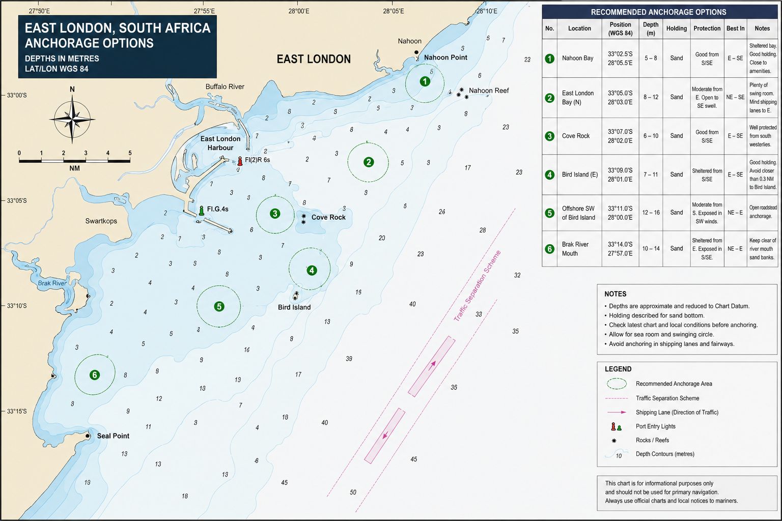
Buffalo River Yacht Club anchorage: The only practical yacht anchorage inside the river lies adjacent to Buffalo River Yacht Club and requires local allocation. Depths are approximately 3–4 m at low water, subject to silting and the position assigned. The bottom consists of mud and river silt. An anchor obtains holding after full penetration, but old mooring lines, debris and existing swing moorings create a fouling risk. The site is protected from ocean swell but remains affected by river current, strong wind above the valley and wash from port craft.
Port roadstead: Port Control can allocate an outer roadstead position in depths from approximately 23 m upward. The bottom is sand and mud with holding suitable for commercial anchoring. The roadstead is exposed to east, southeast, south and southwest swell and wind. It is a traffic-control anchorage rather than a yacht weather refuge. Do not anchor within the commercial approach without an allocated position.
The Nahoon River, Gonubie River and other nearby river mouths are not anchorages for an offshore keel yacht. Their entrances contain bars, shallow water, surf and changing sand. No unrestricted anchorage exists inside the commercial harbour basin.
East London Yacht Cruising
Guide - Entry Formalities
East London is an official South African port of entry and departure for foreign yachts. Complete the national pre-arrival notification process before entering South African waters and submit the Port Arrival Notification no later than 96 hours before arrival. Earlier submission is required where government authorisation, visa confirmation or document correction remains outstanding. Carry the arrival authorisation, crew list, vessel registration, ownership record, insurance, last-port clearance and passports aboard.
Call Port Control before entry and proceed only to the position issued. Fly the Q flag until health pratique and landing permission have been completed. Immigration, Customs, Port Health and harbour officials can attend the yacht or direct the crew to an office. Do not allow crew ashore or land waste, food, animals or equipment before clearance.
Customs processes the yacht under temporary import arrangements and can inspect stores, cash declarations, alcohol, tobacco, spare parts and controlled goods. Immigration checks passports, visas and crew status. Port Health can inspect medical declarations, sanitation conditions and communicable-disease information. Biosecurity controls apply to meat, dairy products, plants, seeds, fresh produce, animal products, pets and waste.
A yacht moving from another South African port normally remains within its existing national clearance status but requires a coastal passage plan and departure approval from the previous port. Notify East London Port Control of the arrival movement and retain the departure documents for inspection. International departure requires the corresponding Immigration, Customs and port clearance before sailing.
Starlink does not have unrestricted licensed retail operation in South Africa. Do not operate a roaming or foreign-registered Starlink terminal unless current ICASA authorisation for that service and equipment can be demonstrated. Possession of type-approved equipment does not by itself authorise provision or use of an unlicensed communications service.
The harbour lies within controlled port property and close to King Phalo Airport controlled airspace. Drone operation requires compliance with South African Civil Aviation Authority rules and written port permission. Do not launch a drone from the yacht, pontoon or harbour land without both aviation and port approval. Photography of security installations, vehicle terminals, port-control equipment and restricted commercial areas also requires permission.
East London Yacht Cruising
Guide - Marina Facilities
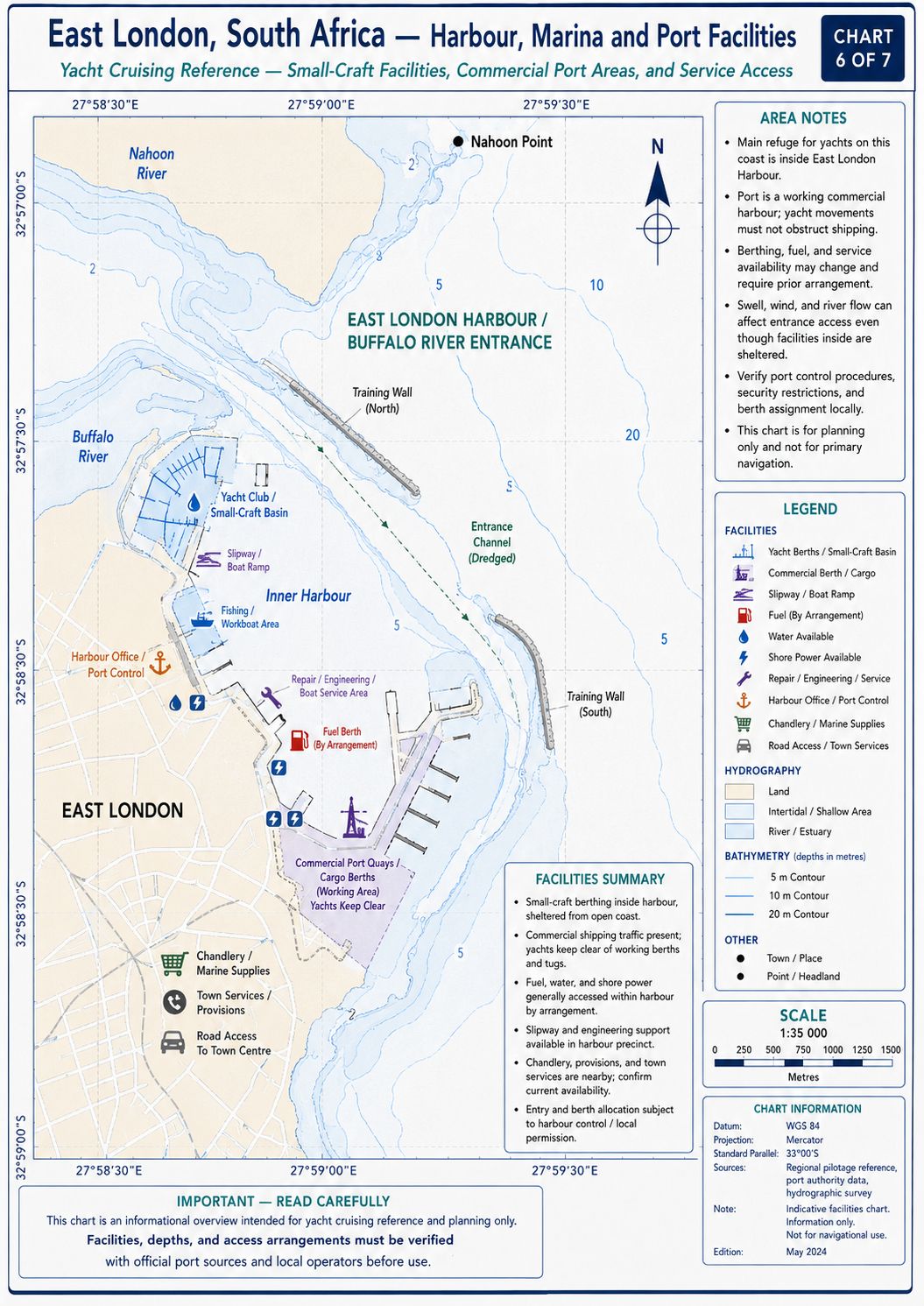
Buffalo River Yacht Club provides the yacht berthing facility in East London. The club lies upriver at approximately 33°01.45′S 027°53.75′E, before the double-decker railway bridge. The former East London Yacht Club is closed and does not provide the visiting-yacht facility. Contact Buffalo River Yacht Club before arrival and obtain the berth, mooring or anchorage position.
The marina has approximately 12 visitor-capable berths. Published limits are 16 m maximum vessel length, 5 m maximum beam and 4 m maximum draught at low water. These limits do not establish 4 m at every berth. Confirm the assigned position against the yacht’s actual draught and the state of tide.
The transit from the commercial basin to the yacht club remains within the Buffalo River channel. Reduce speed before reaching the mooring area because pickup lines and connecting lines can lie close to the surface. Do not pass between moored vessels unless the allocated route is clear. Prepare lines and fenders before entering the final mooring area.
Water, electricity, toilets, showers, laundry, Wi-Fi, controlled access, CCTV, kitchen facilities and fuel bunkering are available through the club. Water and shore power are not guaranteed at every position and require confirmation when the berth is assigned. Test shore-power polarity, voltage and earth continuity before connection.
The alternative to a pontoon or mooring is the adjacent club anchorage allocated by local management. Commercial quays cannot be used as yacht berths without written port authority. No recreational berthing facility exists at the nearby river mouths.
East London Yacht Cruising
Guide - Local Weather
East London receives rainfall throughout the year, with no single dry season controlling passage planning. Summer weather includes northeast and east winds, coastal humidity, thunderstorms, low cloud and periods of rain. Winter weather contains a higher frequency of cold fronts, west winds and southwest changes. Visibility can be reduced by rain, spray, coastal haze and low cloud along the shoreline. Harbour conditions do not represent the sea state over the shelf or in the Agulhas Current.
Ocean swell commonly reaches the coast from the south, southeast or east. Long-period swell can produce breaking water on coastal reefs while the offshore sea appears ordered. A southwest wind opposing the Agulhas Current reduces wave spacing and increases wave face angle. An easterly wind produces an onshore sea at the harbour entrance and reflected waves along the breakwaters. Passage assessment requires the coastal wind, offshore wind, swell period, swell direction, current position and frontal timing to be considered as one system.
East London Yacht Cruising Guide - Local Winds
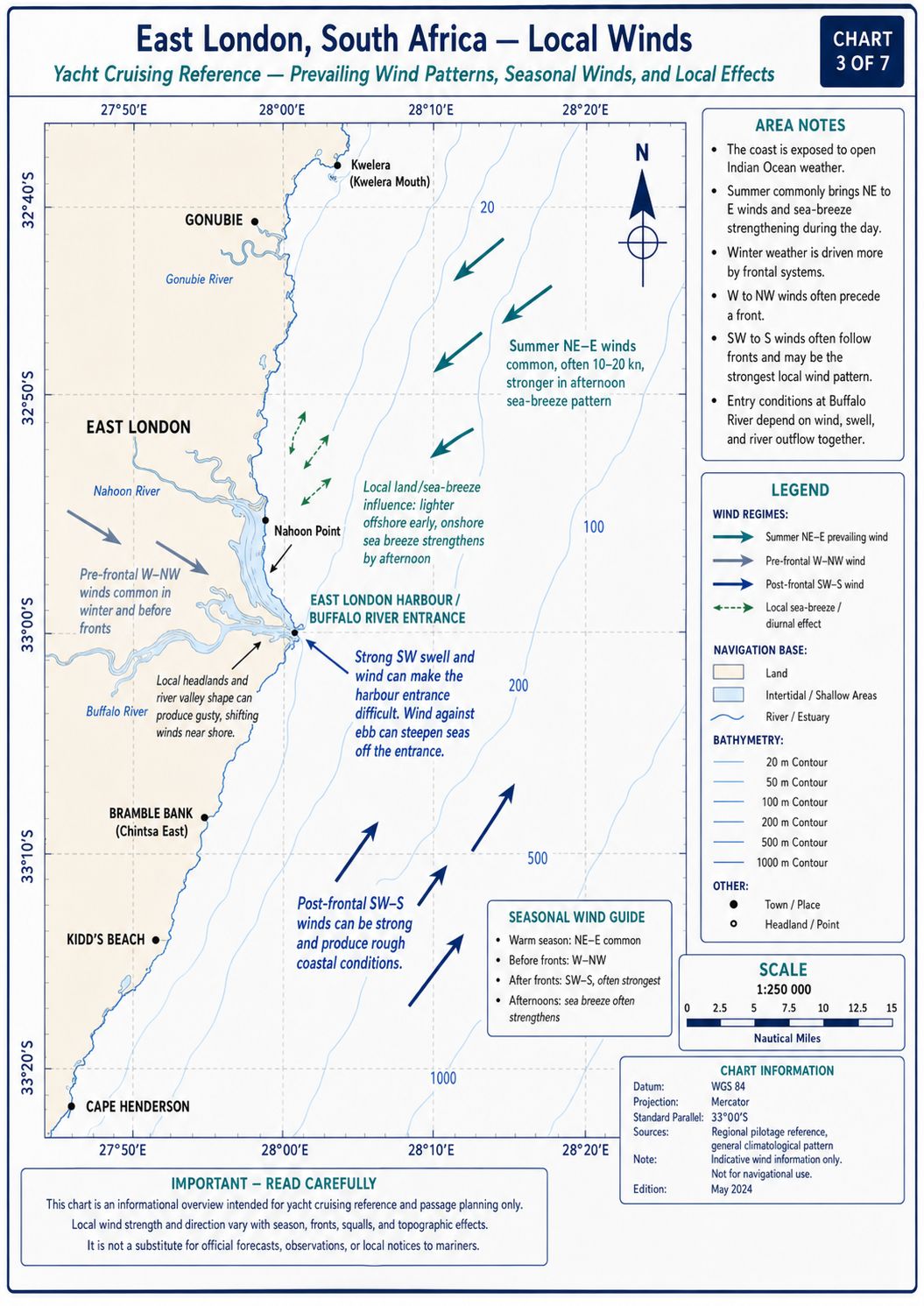
Northeast winds occur most often during spring and summer and can persist for several days between frontal systems. The wind follows the coast toward the southwest and normally runs with the Agulhas Current rather than against it. Sea state still increases with duration, particularly outside the inshore shelf zone. East and southeast winds create an onshore component at East London and increase swell interaction at the harbour entrance. A sustained east-sector wind can also raise the observed water level above the predicted tide.
West and southwest winds follow frontal passages throughout the year and occur more often during winter. The southwest change can arrive with a pressure rise, temperature fall and rapid increase in wind speed. Where this wind opposes the southwest-setting Agulhas Current, the offshore sea can become steep before the full wind strength reaches the coast. Berg winds occur ahead of some fronts as dry winds from the northwest or west, with increased temperature and reduced humidity. East London has no separate local wind name equivalent to the Mistral, Tramontane or Meltemi; forecasts use compass direction and speed.
East London Yacht Cruising
Guide - Provisioning
Supermarkets. Pick n Pay Greenfields, Vincent SUPERSPAR, Checkers Vincent Park, Woolworths Food Vincent Park and Pick n Pay Cambridge provide the main shore provisioning outlets within road range of Buffalo River Yacht Club. Pick n Pay Greenfields lies about 7 km by road from the club and normally operates from 07:00 to 19:00 daily. Vincent SUPERSPAR lies about 9 km by road and operates from 07:00 to 21:00 daily, with public-holiday hours generally reduced to 07:30–20:00. Checkers and Woolworths at Vincent Park lie in the same commercial area. Pick n Pay Cambridge lies about 10 km from the club and generally operates from 08:00 to 19:00 Monday to Saturday and 09:00 to 17:00 Sunday.
Port roads, the river and controlled gates prevent a direct walking route to the major supermarkets. Vehicle transport is required for bulk loads, bottled gas, batteries and fuel containers. Confirm the crew access procedure before leaving the controlled harbour area.
Markets. Buffalo City Metropolitan Municipality Fresh Produce Market operates at Mercator Place in Wilsonia, approximately 9–11 km by road from the yacht club. Buyer trading hours are Monday 06:30–11:00, Tuesday to Friday 06:00–11:00 and Saturday 06:30–09:00. The market is closed on Sundays and public holidays. Border Farmers Market Agents, AA Market Agents and Subtropico operate within the market system. The market handles potatoes, onions, tomatoes, cabbage, leafy vegetables, fruit, citrus and produce from Eastern Cape farming districts. Trade is concentrated in the morning, and access outside buyer hours does not provide a retail market service.
Fish Markets. Nahoon Fisheries operates at Nahoon, approximately 10–12 km by road from Buffalo River Yacht Club. Normal trading is from about 10:00 to 18:45 on weekdays, with shorter weekend hours. Grand Prix Fisheries and Econo Foods provide other shore-based seafood outlets. The former Sea Spirit Fish Market on the harbour east bank is closed and cannot be used as a current source of fish.
Local and regional species include Cape hake; kob or kabeljou, meaning dusky kob; geelbek, also called Cape salmon; snoek, meaning Cape snoek; yellowtail; carpenter; kingklip; sole; tuna; red roman; maasbanker, meaning horse mackerel; pilchard; calamari and mussels. Availability depends on quota, season, sea state and landings.
East London Yacht Cruising
Guide - Local Cuisine
Eastern Cape food culture includes isiXhosa maize, bean, vegetable and meat dishes. Umngqusho is samp cooked with sugar beans. Umleqwa is mature free-range chicken cooked until tender. Umphokoqo is crumbed maize meal served with amasi, a cultured sour milk. Imifino consists of cultivated or gathered greens cooked with maize meal, while pumpkin and pumpkin leaves are used in ilaxa and related dishes.
Coastal cooking uses hake, kob, geelbek, yellowtail, snoek, calamari, mussels and sardines. Hake is used for fried fish and chips. Kob and geelbek are grilled, baked or cooked in tomato and spice sauces. Seafood curries reflect Cape and Indian Ocean cooking methods. Regional produce includes citrus, pineapples, dairy products, lamb, maize and beans from the wider Eastern Cape.
East London Yacht Cruising Guide - Beverages
Table 58 Brewing operates in
East London and produces lager, pilsner, wheat beer, porter and India pale ale.
Emerald Vale Brewery operates outside the city and supplies beer through local
outlets. South African commercial lager brands are available from licensed
bottle stores and supermarkets. Mageu is a
non-alcoholic fermented maize drink used across the Eastern Cape. Amasi is
consumed as cultured milk and with maize dishes.
East London Yacht Cruising
Guide - Fuel Supplies
Buffalo River Yacht Club provides fuel bunkering by arrangement. There is no confirmed permanently staffed retail diesel bowser on the visitor pontoon. Delivery can require a vehicle, approved supplier or portable-container transfer through port security. Confirm the delivery method, minimum quantity, payment method and gate access before ordering.
Use diesel from a registered fuel supplier and obtain the grade and delivery quantity before transfer. No recurring East London port-specific diesel contamination problem is established. Fuel carried in informal or reused containers has no traceable quality control. Filter container-transferred diesel and prevent river water, rain and port dust from entering the deck filler.
East London Yacht Cruising
Guide - Water Supplies
Potable municipal water is available through Buffalo River Yacht Club. Supply can be from a pontoon connection, club hose point or arranged transfer depending on the allocated berth. Confirm water access when the berth is assigned because not every mooring carries a permanent connection.
The municipal supply is treated for potable use. Flush the outlet and hose before connecting to the yacht. Use a dedicated potable-water hose and prevent its end contacting the river or pontoon surface. Where water is delivered by tanker, confirm that the tanker is certified for potable-water carriage.
Mechanical and Electrical Repairs
Resource
Why not get a copy of my book The Marine and Electrical and Electronics Bible 4th Edition. . Your complete systems guide. 650 pages of practical advice. In Australia and New Zealand order a copy through Boat Books. UK and European boats can buy the UK Edition Here. US and Canadian boats can get the US Edition Order Here. Marine systems are my profession so let me help you. In South Africa you can buy the book through Amazon or Loot.co.za or Kobo.co.za


East London Yacht Cruising
Guide - Marine Services
Bay Way Marine Electronics provides regional Eastern Cape service for Raymarine, Simrad, B&G, Garmin, Icom, Digital Yacht, Ocean Signal and related navigation and communications equipment. Confirm travel availability and port access before scheduling an onboard visit. No current authorised East London yacht-diesel agent has been confirmed for Volvo Penta, Yanmar, Nanni, Vetus or Beta Marine. A general diesel workshop does not establish manufacturer authorisation or marine installation competence. Chandlery supply is limited, and specialised parts may need to be sourced from Durban or Cape Town. Buffalo River Yacht Club identifies haul-out capability, but lifting limits are not published.
OSASA - South African Yacht
Assistance
The Ocean Sailing Association of Southern Africa (OSASA) came into being during the COVID pandemic crisis where they actively assisted entry to South Africa by cruising yachts into its various ports. It is a non-profit company created to liaise with Maritime officials to facilitate entry to South African ports at the time. OSASA was assigned by the SA Department of Transport to handle the mandatory pre-arrival authorisation (PAN) for all incoming non-SOLAS yachts, both local and foreign. OSASA services include the following:
- Manage and update the online registration portal for incoming non-SOLAS vessels
- Manage the pre-arrival authorisation (PAN) process with the Department of Transport for incoming small vessels at the Ports of Entry
- Provide up-to-date information for cruising yachts navigating South African ports and coastal waters
- Develop and maintain a good working relationship with SA maritime authorities and port officials, and with local offshore yacht clubs and marinas
- Work with local offshore clubs and marinas to develop and enhance their facilities
Cruising yacht visitors are encouraged to contact OSASA. They are a group of willing and like minded volunteers along the South African coastline and will assist with the needs of cruising yachts. This group is known as the OSASA Port Ambassadors and will assist cruising yachts with anything that may be required. Anything from entry procedures right down to directing you to the nearest dentist or barber and anything in-between. There is a published list on the OSASA website as well as on the Sail to South Africa WhatsApp group of the individual OSASA port Ambassadors. Ports and marinas that are covered are Richards Bay; Durban; East London; Port Elizabeth; Port St. Francis; Knysna; Mossel Bay; Gordon's Bay, False Bay YC (Simon's Town), Hout Bay, Saldanha Bay; Port Owen; Cape Town (V&A Waterfront and Royal Cape YC).
East London Yacht Cruising
Guide - Local Etiquette
The operational port name is Port of East London. Use “East London Port Control” for VHF communication and formal port movements. English, isiXhosa and Afrikaans are used in the city. In isiXhosa interaction, begin with molo when addressing one person or molweni when addressing more than one person before stating the request.
The port is a controlled industrial area. Carry identification and the access permit issued for crew movement. Contractors, taxis and delivery vehicles require gate clearance before entry. Do not photograph port security, vehicle-export areas, officials or control equipment without permission.
Wrecks, pottery, fittings, fossils and archaeological material cannot be removed from the shore or seabed. Report an exposed object rather than moving it. Permission is required before diving within port limits or near commercial infrastructure.
East London Yacht Cruising
Guide - Summary
East London is a controlled river port at the mouth of the Buffalo River. The 12 m commercial entrance channel provides yacht access under Port Control direction on VHF Channel 12. Buffalo River Yacht Club provides berthing, moorings, water, shore power and arranged fuel, subject to position and depth confirmation. Coastal passage planning requires control of the Agulhas Current, southwest changes and the requirements of the East London sailing cruising guide. East London Yacht Cruising Guide for all you need to know