Durban Yacht Cruising Guide
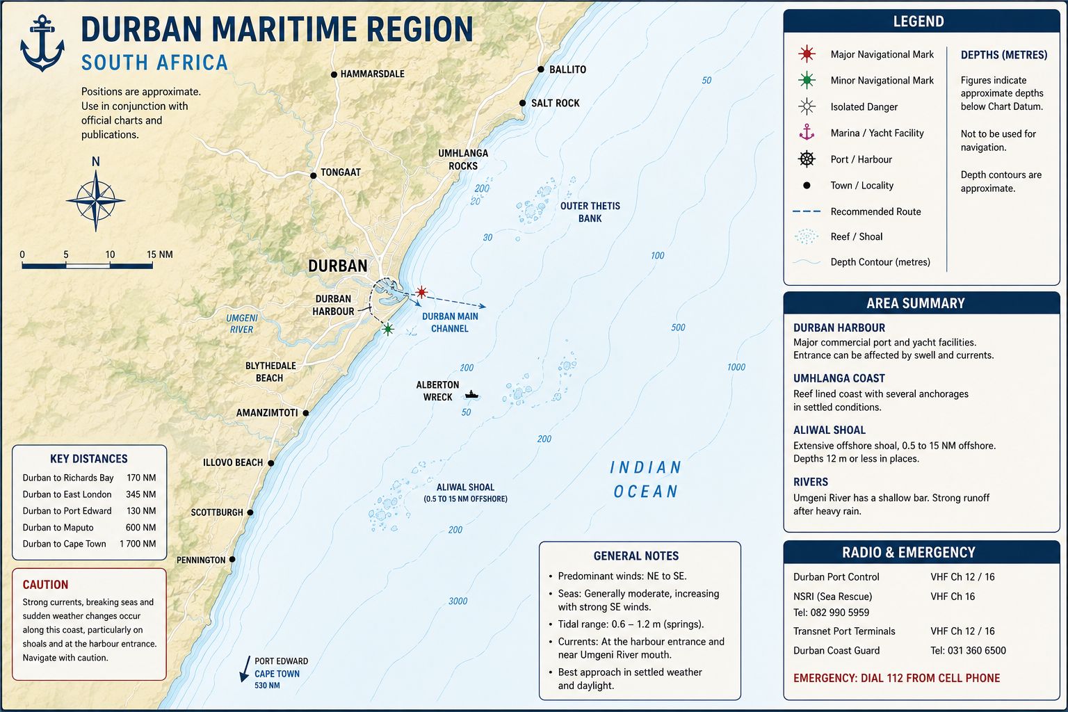
Durban Yacht Cruising Guide. Durban lies on the KwaZulu-Natal coast between the Umgeni River and the Bluff headland. The port occupies Durban Bay, a former estuarine lagoon connected to the Indian Ocean through a trained entrance. Port activity includes containers, petroleum products, bulk cargo, vehicle handling, fishing, ship repair, naval support and small craft. The city is a South African entry and departure point for vessels moving between the Mozambique Channel, the South African east coast and the Cape route. International yachts use Durban for clearance, repairs, stores, crew movements and weather-bound coastal stops.
Offshore waters are controlled by the southwest-flowing Agulhas Current and the narrow continental shelf along the KwaZulu-Natal coast. The current can run within 10–20 nautical miles of the shore, with its inshore boundary changing through meanders and Natal Pulse events. Northeast and southwest wind systems determine coastal sea state, while summer thunderstorms create short periods of reduced visibility and wind shifts. River discharge after heavy rain can carry sediment, timber and waste into the nearshore water. Durban Harbour operates throughout the year as a commercial port under vessel traffic control..
Durban Yacht Cruising Guide - History
The Durban Bay area was occupied before European settlement by communities using the estuary, coastal forest and adjoining rivers for fishing, shellfish collection, transport and agriculture. The bay contained mangroves, tidal creeks, sandbanks and mudflats before port construction altered the shoreline. Portuguese navigator Vasco da Gama reached the coast on 25 December 1497 and named the area Rio de Natal. European vessels later used the bay as an anchorage and watering location, although the entrance bar restricted access by ships. A British trading settlement was established beside the Bay of Natal in 1824, and the settlement was named Durban in 1835.
Harbour development required repeated dredging, reclamation and training-wall construction to create a stable entrance through the sandbar. The Point, Maydon Wharf, Bayhead and Island View areas were formed or altered as cargo handling expanded. Royal Natal Yacht Club developed from the first organised Durban regatta in 1858 and received its royal charter in 1891. Port expansion removed most of the original mangrove system and covered sections of the former shoreline beneath reclaimed land. Maritime archaeological potential remains around Maydon Wharf, the former foreshore, buried wharf structures and wreck deposits within the port-development area.
Durban Yacht Cruising
Guide - Approaches
Durban Yacht Cruising Guide. From the south, remain clear of the Bluff coast and Aliwal Shoal passage sector while approaching Durban. The coastline north of the Bluff contains beaches, surf zones, submarine pipelines and port infrastructure. Maintain water deeper than 30 metres until the harbour entrance, breakwaters and leading marks agree with the electronic position. Commercial ships converge on the Durban approach from southeast, east and northeast. Do not enter a commercial approach lane or cross ahead of a ship aligned with the entrance.
From the north, remain outside the surf-backed coastline between Umhlanga, the Umgeni River and Durban. The inshore boundary of the Agulhas Current can set the yacht southwest past the harbour latitude before the entrance is visually identified. Establish a controlled course-over-ground track before reducing the distance offshore. The low northern shoreline and urban lighting make the entrance difficult to separate during rain, haze or darkness. Radar ranges to the breakwaters and AIS traffic information are required when visual definition is reduced.
Call Durban Port Control before crossing into the controlled approach sector. Do not use the commercial anchorage, pilot boarding ground or entrance channel as a sail-reduction area. Complete engine checks, secure loose deck equipment and prepare mooring lines before closing the 12-nautical-mile reporting line. Ships can alter speed or hold position while awaiting pilotage, and their heading does not establish that the channel is open. Maintain enough sea room to wait outside the harbour if Port Control delays the entry.
Durban Yacht Cruising Guide - Ocean Currents and Tidal Flow
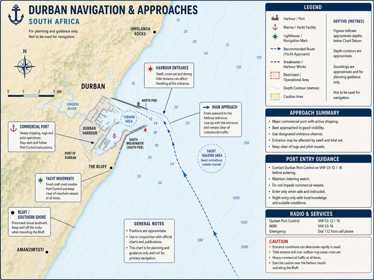
The Agulhas Current flows southwestward offshore of Durban at approximately 2–4 knots, with stronger flow possible within the current core. Its inshore edge moves according to meanders, eddies and Natal Pulse events passing down the coast. A yacht approaching from the north can receive a following current that increases speed over ground while reducing the time available for harbour-entry preparation. A northbound yacht can lose several knots when operating in the main current. The current position must be established from sea-surface temperature, course over ground, speed through the water and current forecast products rather than from a fixed charted boundary.
The Natal Bight south of Durban can contain an inshore countercurrent running northeastward between the coast and the main Agulhas Current. This countercurrent is not permanent and can reverse under sustained wind. Southwest wind opposing the Agulhas Current produces steep waves, short wave spacing and breaking crests offshore. A yacht must not enter the current core during an established southwest gale. When a southwest change is forecast, remain inside the weaker shelf water only where depths, traffic separation and sea room permit.
Durban has a semi-diurnal tide with two high waters and two low waters during each lunar day. The normal spring range is approximately 1.7–2.0 metres, while the neap range is approximately 0.6–0.8 metre. Tidal streams within the commercial entrance remain weak compared with tug wash, propeller flow and wind-driven surface movement. Tide height affects clearance at the yacht marina, internal quays and shallow margins of the Yacht Basin. Apply the current Durban tide-table height to chart datum when calculating berth and fairway clearance.
Durban Yacht Cruising Guide - Navigation
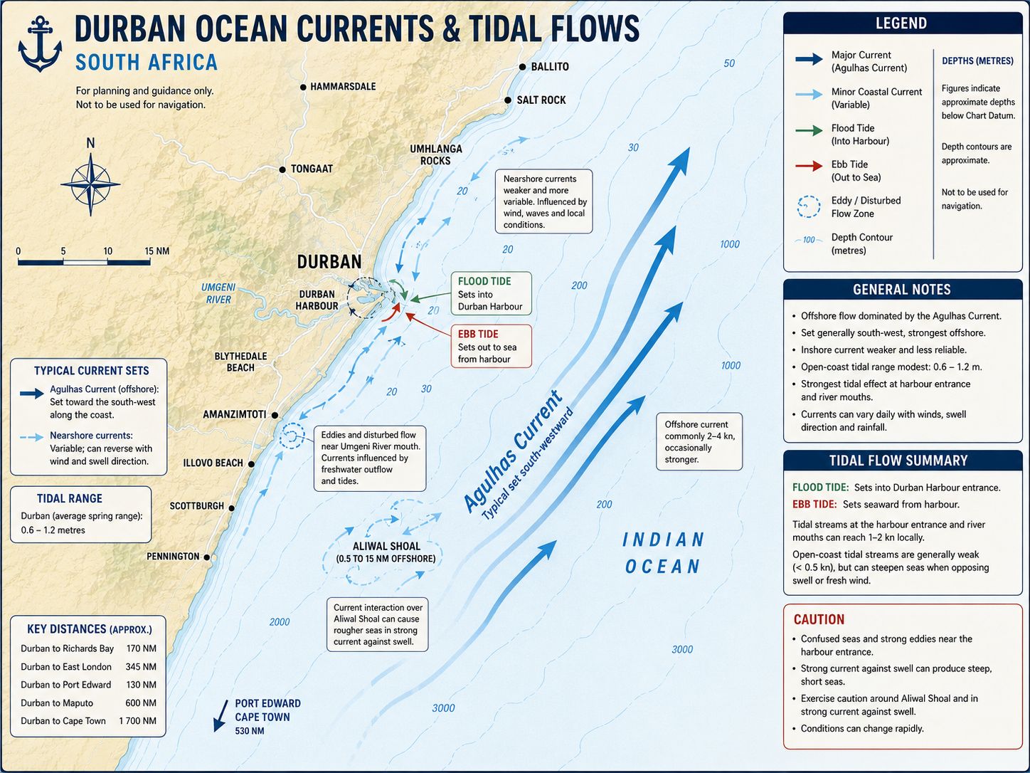
Contact Durban Port Control on VHF Channel 9 approximately one nautical mile from the breakwater, or earlier when directed by the vessel-traffic service. State the yacht’s name, call sign, position, length, beam, draught, last port, clearance status and intended berth. Maintain a listening watch on Channels 9 and 16 and keep AIS transmitting. Durban VTS operates continuously and monitors traffic to approximately 25 nautical miles offshore. Do not enter the commercial channel until Port Control gives direct permission.
The harbour signal system provides an additional indication of entrance status. No signal light indicates that the entrance is clear, although VHF clearance remains mandatory. A red light indicates that a ship is leaving and the yacht must keep clear. A green light indicates that a ship is entering and the yacht must remain outside. A flashing red light indicates that the port is closed.
The entrance is marked by the North Breakwater green light and South Breakwater white light. Enter on the side of the channel directed by Port Control and remain clear of vessels constrained by draught. The commercial entrance depth is substantially greater than yacht draught, but active temporary notices affect depths and report a shoal within the port area. The corrected harbour chart and current Port Control instruction control over stored electronic-chart values.
After passing the breakwaters, alter to starboard for Silburn Channel and the Yacht Basin. Remain outside tug berths, commercial turning areas and the routes used by pilot boats and harbour craft. Contact Durban Marina before reaching the Yacht Mole and obtain the assigned visitor position. International arrivals proceed to the clearance berth specified by Port Control or the marina. Do not enter an unallocated private berth because it appears vacant.
Durban Yacht Cruising Guide - Lighthouses and Lights
Durban South Breakwater Light — D6464. The South Breakwater Light stands on the southern entrance structure at approximately 29°51.9′S, 31°03.8′E. The light characteristic is Fl(2) W 5s, displaying two white flashes every 5 seconds. The focal height is approximately 14 metres, with a nominal range of about 18 nautical miles. The structure is a red tower despite the white light characteristic. The light marks the southern breakwater and not the centre of the navigable channel. Spray can obscure it during northeast or southwest sea conditions. Port lighting, crane lighting and ship deck lights can reduce its definition after dark. Confirm its position by radar before closing the entrance.
Durban North Breakwater Light — D6466. The North Breakwater Light stands at approximately 29°51.99′S, 31°03.45′E. The characteristic is Fl G 3s, displaying one green flash every 3 seconds. The focal height is approximately 14 metres, and its nominal range is about 15 nautical miles. It marks the northern side of the commercial entrance. Do not steer directly toward the green light because the light marks the end of the structure rather than a route through the channel. A yacht entering under crosswind must retain enough speed for steering control while remaining within the sector assigned by Port Control.
Durban Entrance Leading Lights — D6472 and D6472.1. The Durban entrance range lies on a bearing of approximately 215°30′. The front light displays Iso R 2s, with equal periods of red light and darkness over a 2-second cycle. The rear light displays Oc W 4s, with a white occulting characteristic over a 4-second cycle. When aligned, the two lights identify the commercial entrance-channel centreline. A yacht does not occupy the leading line without Port Control approval. Deep-draught ships, tugs and pilot vessels use the same alignment. Industrial background lighting can make the rear light difficult to separate. Radar and VTS instructions remain required.
Durban Entrance Directional Light — D6472.2. The directional light displays white, red and green sectors covering the entrance approach. The white sector identifies the intended directional line, while the coloured sectors indicate displacement to either side. Sector boundaries must be checked against the current List of Lights. The directional light does not replace VHF clearance.
NSRI Jetty and Entrance-Channel Lights. Lights mark the northern entrance-channel structures, NSRI jetty and internal quay heads. These aids identify local obstructions and service positions rather than a recreational-yacht leading route. Rescue craft can depart without delay and retain priority over marina traffic. Keep the NSRI approach clear.
Small Craft Basin Lights. Lights D6475.2, D6475.3 and D6475.4 mark structures within the Small Craft Basin and Yacht Mole sector. They identify fixed quay and breakwater ends but do not indicate an available berth. Proceed only to the position allocated by Durban Marina. Fishing vessels, club launches and workboats can obscure the lights at close range.
Cooper Lighthouse — D6458. Cooper Lighthouse lies south of Durban and provides a coastal reference for vessels approaching from the southwest. It does not provide a harbour approach line. The current characteristic, range and operational status must be taken from the South African List of Lights. The light can remain visible while the Durban entrance is obscured by rain.
Umhlanga Rocks Lighthouse — D6480. Umhlanga Rocks Lighthouse lies north of Durban and provides a coastal reference for vessels approaching from Richards Bay. It marks the coastline but not a safe inshore track. The coast between Umhlanga and Durban remains surf-backed and contains shallow water near the beach. Verify the current light characteristic from the corrected List of Lights.
Durban Yacht Cruising Guide - Chart Accuracy
Use SAN 1029, INT 7563, Approaches to Durban–SAN Oil Terminal SBM, at approximately 1:30,000 where the offshore oil-terminal sector affects the route. Use SAN 1030, INT 7561, Approaches to Durban, at approximately 1:30,000 for the main approach. Use SAN 1031, INT 7562, Durban Harbour, at approximately 1:10,000 for the breakwaters, commercial channels, Silburn Channel and Yacht Basin. Small-craft chart SAN SC12, Durban to Richards Bay, includes a Durban Harbour inset at approximately 1:7,500.
Active temporary notices amend Port of Durban depths, identify a reported shoal and record a non-operational RACON. These corrections must be applied before arrival. Commercial dredging maintains the main entrance and ship channels but does not establish the depth of marina fairways or berth pockets. Electronic chart updates can lag temporary dredging information and local buoy movements. Port Control, corrected official charts and the yacht’s sounder control where they conflict with an old electronic route.
The harbour shoreline contains reclaimed land, quay extensions, terminal structures and operational exclusion areas. Satellite imagery can show fixed structures but cannot establish navigable depth or current access. AIS targets do not display every tug, workboat or small craft. Use radar, visual marks and a bow lookout through the internal channels.
Durban Yacht Cruising Guide - Weather
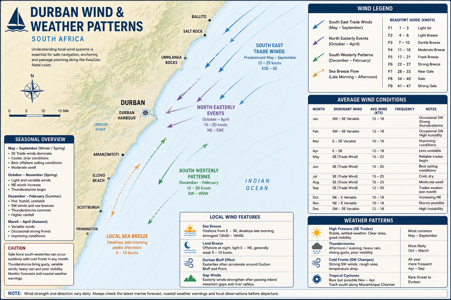
Durban has a humid subtropical climate with summer rainfall and drier winter periods. Summer weather from approximately October to March includes high humidity, northeast wind, thunderstorms and periods of heavy rain. Thunderstorms can move from the interior or develop along the coastal convergence zone. Wind can shift by more than 90 degrees as a gust front crosses the harbour approach. Heavy rain reduces radar definition close to the breakwaters and can obscure navigation lights.
Winter weather contains longer settled intervals separated by cold fronts and southwest changes. A pre-frontal berg wind can produce high temperature, dry air and haze before pressure falls. The southwest change can arrive as a defined line of cloud, rain and wind, with a rapid increase from less than 10 knots to more than 30 knots. Offshore conditions deteriorate where the new wind opposes the Agulhas Current. The sea can remain steep after the local wind has reduced because the current continues to oppose the residual swell.
Tropical cyclones rarely make direct landfall at Durban. Systems in the Mozambique Channel or southwest Indian Ocean can still produce northeast swell, heavy rain and abnormal pressure patterns along the KwaZulu-Natal coast. Long-period swell can arrive before the storm circulation reaches the latitude of Durban. Port entry remains possible where commercial-port limits are met, but yacht handling inside the entrance can be affected by surge and crosswind. Current harbour restrictions control over general coastal forecasts.
Durban Yacht Cruising Guide - Local Winds
The northeast wind is the main warm-season coastal wind. It normally develops during the morning and increases through the afternoon, reaching 15–25 knots during an established coastal pressure gradient. The wind runs along the coast and creates a short sea over the inshore shelf. Several days of northeast wind increase humidity and can precede a southwest change. The wind crosses the port entrance and produces load on yachts berthed in the Yacht Basin.
The southwest wind is the controlling offshore-passage wind. It follows cold fronts, coastal lows or pressure surges moving north along the coast. The change can arrive with little transitional wind and can exceed 30 knots within a short period. Southwest wind against the Agulhas Current produces the principal heavy-weather hazard between Durban and Richards Bay. A northbound departure is not made while a developed southwest wind is operating against the current.
A berg wind reaches Durban from west or northwest after descending from the interior. It produces higher temperature, lower humidity and reduced visibility from haze, smoke or dust. The inshore sea can remain flat during the offshore phase while frontal weather approaches from the south. Mooring preparation must account for the later southwest change rather than the initial offshore direction.
Durban Yacht Cruising
Guide - Anchorage
Durban Yacht Basin Anchorage. The authorised small-craft anchoring area lies near 29°51′53.91″S, 31°01′36.62″E, east of the main yacht-club mooring rows and clear of the commercial harbour channel. Depth is approximately 4–6 metres over soft mud and sand, subject to the exact position and state of tide. Holding is secure after the anchor penetrates the mud layer. Set the anchor under engine load and verify the full swinging circle against nearby catamarans, moorings and channel limits.
The position is protected from ocean swell by the commercial breakwaters. Northeast and southwest winds still generate short chop within the harbour. Tug wash, pilot-boat wake and passing commercial craft can load the anchor and move the yacht through several metres. Anchoring requires approval from Durban Marina or Port Control, and the yacht must remain outside every marked fairway.
International Jetty Waiting Position. The International Jetty carries approximately 3.5 metres at low water and is used for visiting yachts, clearance and temporary berthing. It is a jetty position rather than an anchorage. Approach only after berth allocation and place fenders at waterline level because the quay and yacht freeboard can differ. The yacht can be required to move after clearance or when another international arrival is expected.
Commercial Table Anchorage. The commercial anchorages outside Durban are controlled by Port Control. Depths are generally 20–40 metres over sand, mud and mixed ground. These positions are intended for ships awaiting pilotage or berth allocation and are not unrestricted yacht anchorages. A yacht uses a commercial anchorage only after receiving an assigned position.
The offshore anchorage is exposed to northeast swell, southwest wind and the inshore edge of the Agulhas Current. Holding load increases when wind and current oppose each other. Keep the engine available and maintain a continuous listening watch. Port Control can order the yacht to move without delay.
Bluff and Bayhead Channels. No free anchorage exists within the Bluff, Bayhead, Maydon Wharf or Island View channels. These waters contain commercial berths, tug routes, ship channels, swing basins and industrial facilities. Anchoring is prohibited unless Port Control issues an emergency instruction. Use only an allocated yacht-club berth, mooring or harbour-authorised working position.
Open Coast North and South of Durban. The coastline north and south of Durban does not provide a viable yacht anchorage. The shore is backed by surf, the seabed shoals gradually and the positions remain exposed to northeast and southwest weather. River mouths can discharge debris and sediment after rain. A yacht unable to enter Durban remains offshore or diverts to another port rather than anchoring close to the beach.
Durban Yacht Cruising
Guide - Entry Formalities
Durban is a South African maritime port of entry and departure. International non-SOLAS yachts must complete the national pre-arrival registration and obtain the required pre-arrival notification approval at least 96 hours before arrival. Submit vessel registration, crew details, passport information, last-port clearance, voyage data, insurance and the estimated arrival time. Update the estimated arrival when weather or current changes it materially.
Notify Durban Port Control that the yacht requires international clearance. Proceed only to the berth assigned for Port Health, Border Management, Immigration and Customs attendance. Port Health clearance is completed before crew land or other entry processes proceed. No person leaves the yacht and no rubbish, stores, animals or equipment are landed before release.
Each traveller completes the South African traveller declaration required by Customs. Declare firearms, ammunition, controlled medicines, currency, alcohol, tobacco, commercial goods and equipment intended for sale. Meat, dairy products, plants, seeds, fresh produce, animals and animal products remain subject to agricultural or veterinary control. International waste uses the disposal route authorised by the port.
Pets require the applicable South African import permit, veterinary health certificate, vaccination records and identification. Where Durban is not authorised to complete the required veterinary inspection for the animal category, the animal remains aboard until transfer to the Cape Town veterinary process or another authorised arrangement. Do not land a pet on the basis that Immigration and Customs have cleared the crew.
After South African arrival clearance, the yacht retains the issued documents for coastwise movement. File the required coastwise passage plan before leaving Durban for another South African harbour. International departure clearance is completed before leaving South African waters. Durban Marina records the first South African entry port and clearance status as part of the visitor process.
Starlink and other satellite communication terminals remain subject to ICASA service licensing, spectrum controls and equipment type approval. Foreign registration or a roaming account does not create a South African exemption. Port security can direct that transmitting equipment be switched off within controlled areas. Keep proof of equipment approval where operation has been authorised.
Drone operation requires South African civil-aviation compliance, port-security approval and landowner permission. Do not launch from Durban Marina, a commercial quay, a yacht inside the port or a public waterfront position without written authority. Flights over ships, petroleum facilities, container terminals, security points, harbour workers and crowds are prohibited without the applicable approvals. Helicopter, airport and port operations create additional airspace restrictions.
Durban Yacht Cruising
Guide - Marina Facilities
Durban Marina and Yacht Mole. Durban Marina controls the walk-on berths, visitor positions and anchoring area within the Yacht Basin. The facility gives direct shore access to Royal Natal Yacht Club and Point Yacht Club. A berth requires an online or direct booking and payment confirmation. A coastwise passage plan or arrival notice does not constitute a marina reservation.
The International Jetty carries approximately 3.5 metres at low water. Depths at other walk-on berths vary according to position, silting and dredging. Yachts longer than 20 metres or wider than 8 metres require direct dimensional approval before arrival. Provide the yacht’s actual loaded draught rather than the builder’s design figure.
The published arrival position is approximately 29°51′46.84″S, 31°01′18.25″E. Approach the allocated jetty at minimum wash and use waterline-level fenders where securing alongside a fixed face. Do not enter an unallocated pen. Marina staff can direct the vessel to the anchoring area where no berth is immediately available.
Fresh municipal water is available through the marina system. Shore electricity is available at selected equipped positions and requires confirmation of voltage, amperage and connection type. The facility provides 24-hour security and controlled shore access. Waste disposal, laundry arrangements and road transport can be coordinated through the marina office.
Royal Natal Yacht Club and Point Yacht Club provide toilets, showers, ablutions, club facilities and access arrangements for visiting crews. Use of club buildings remains subject to temporary membership, reciprocal-club arrangements or current visitor rules. The clubs do not replace the marina’s berth-allocation authority. An available club-side space is not occupied without Durban Marina approval.
The marina office requires passports, vessel-registration documents and arrival information after securing the yacht. Harbour or port charges can apply to extended stays, including visits exceeding 30 days. Departure procedures must be completed before casting off. Weekend or public-holiday international clearance requires advance coordination because agency office availability is restricted.
Royal Natal Yacht Club. Royal Natal Yacht Club occupies the Yacht Mole beside Durban Marina. It provides club facilities, organised sailing activity and shore access for members and authorised visitors. The club does not independently control the international arrival berth or all marina moorings. Visiting crews register under the current club and marina arrangements. The club’s published operating schedule varies by day, with Monday closure and service from Tuesday through Sunday. Arrival outside club hours does not permit access to locked facilities or private berths. Port and marina security continue operating independently of club hospitality hours.
Point Yacht Club. Point Yacht Club operates from the Yacht Mole and provides shore facilities for sailing and boating activity. Access to showers, toilets, club spaces and other services depends on current visitor or reciprocal arrangements. Berthing remains controlled through Durban Marina. Do not use a Point Yacht Club landing or berth without allocation.
Bluff Yacht Club and Bayhead Facilities. Bluff Yacht Club operates within the Bayhead sector and provides mooring, haul-out and maintenance access by advance arrangement. Reaching the club requires transit through controlled commercial-port water. Port Control approval is required for every movement between the Yacht Basin and Bayhead. Depth, berth dimensions and haul-out limits require direct confirmation for the yacht.
The Bayhead position is not used as an international clearance berth unless directed by the authorities. Commercial traffic, tugs and industrial operations occupy the adjoining channels. A yacht moves there only after securing the berth and access arrangements
Durban Yacht Cruising
Guide - Provisioning
Supermarkets. Marina KWIKSPAR, uShaka KWIKSPAR, Checkers Windermere and North Beach SPAR provide the principal supermarket options within road access of Durban Marina. Marina KWIKSPAR is at John Ross House on Margaret Mncadi Avenue, approximately 0.5–1 kilometre from the Yacht Mole. uShaka KWIKSPAR is on Rutherford Street, approximately 3–4 kilometres by road from the marina. North Beach SPAR is on Somtseu Road, also approximately 3–4 kilometres away.
Checkers Windermere operates from Windermere Centre on Lilian Ngoyi Road, approximately 5–6 kilometres from the Yacht Mole. Published trading is generally from 08:00 to 20:00, subject to Sunday and public-holiday amendments. The store provides the principal full-line option where local marina-area stock is insufficient. A road vehicle or delivery service is required for large loads. Deliveries require the correct gate, yacht name, berth number and crew contact. Keep chilled and frozen stores insulated because security procedures can delay vehicle access. Gas cylinders and fuel containers require separate handling from food deliveries.
Markets. Victoria Street Market operates in the central Durban market district approximately 2–3 kilometres from the Yacht Mole. Published hours are 08:00–17:00 Monday to Friday, 08:00–16:00 Saturday and 09:00–15:00 Sunday. The market sells spices, vegetables, fruit, dried foods, seafood and household goods through individual traders.
The Warwick Junction precinct contains produce and street-trading areas around the main transport interchange. Operation begins during the morning and continues through the working day, with individual stalls setting their own hours.
Fish Markets. Barthos Fish Company operates from the Woolworths Centre on Mackeurtan Avenue in Durban North, approximately 10–12 kilometres by road from the Yacht Mole. Published hours are 09:00–17:00 Monday to Friday and 08:00–13:00 Saturday, with Sunday and public-holiday closure. The outlet sells fresh and frozen seafood according to supply. Seafood Market Durban operates retail outlets in Springfield and Durban North. Supply includes line fish, prawns, crab, shellfish and frozen products. Friday trading includes a closure during the midday prayer period.
Commercial fishing quays inside Durban Harbour are restricted. Do not enter a landing area, cold store or vessel without permission. Direct purchase from a vessel requires an authorised sale and approval from the vessel operator and port facility.
Regional species include couta, meaning king mackerel; dorado, meaning mahi-mahi; yellowfin tuna; queen mackerel; shad, also called elf; kob, also called daga salmon or kabeljou; geelbek, also called Cape salmon; rockcod or grouper; sardines; prawns; crab and squid. Availability depends on commercial landings, weather, seasonal closures and catch controls.
Durban Yacht Cruising
Guide - Local Cuisine
Durban cuisine reflects Indian, Zulu and coastal KwaZulu-Natal food traditions. Bunny chow consists of curry served inside a hollowed loaf of bread. Fillings include beans, chicken, mutton or beef, with the bread removed from the centre used as a cover. Durban curry uses onion, tomato, chilli, garlic, ginger and a spice mixture with greater chilli content than several other South African curry styles.
Breyani, also written biryani, combines spiced rice, meat or chicken, lentils and potatoes. Samoosas are pastry triangles filled with spiced meat, chicken or vegetables. Chilli bites, also called bhajia, use gram-flour batter with spices and vegetables. Fish curry and prawn curry use regional seafood with tomato, tamarind, chilli and spice.
Zulu dishes include ujeqe, a steamed bread served with meat, beans or gravy. Phuthu is crumbed maize meal eaten with beans, meat, amasi or vegetable relish. Umngqusho combines samp and beans. Chakalaka is a cooked relish containing onion, tomato, beans, carrot and chilli.
Umleqwa is free-range chicken cooked until tender. Ulusu is tripe served with maize meal or steamed bread. Inyama yenhloko is meat from a cooked cattle head. Shisa nyama describes meat cooked over an open fire and served with maize meal, bread or relish.
Durban’s coastal dishes include grilled couta, dorado, yellowfin tuna, prawns and squid. Sardines are fried, grilled or preserved during legal supply periods associated with the winter sardine migration.
Durban Yacht Cruising Guide - Local Beverages
Robsons Real Beer has a Durban and Point-area brewing history. Durban Pale Ale and stronger ale styles have been associated with the brand. Confirm the current packaged range before recording supplies for a passage. Other KwaZulu-Natal producers include Nguni Brewing Company in Pinetown and 1000 Hills Brewing Company inland from Durban. National beers include Castle Lager, Castle Lite, Carling Black Label and Hansa Pilsener.
Distillery 031 produces Durban Dry Gin and other spirits. Its range has included vodka, cachaça and absinthe products. South African brandy, cane spirit, gin and Amarula cream liqueur are available through licensed retailers.
Umqombothi is a traditional fermented beer produced from maize and sorghum malt. Amahewu is a non-alcoholic fermented maize drink.
Durban Yacht Cruising
Guide - Fuel Supplies
Durban is a commercial bunkering port, but the ship-fuel system is not an unrestricted self-service yacht fuel dock. Yacht diesel is arranged through Durban Marina, an approved harbour supplier or a road-delivery contractor. Confirm the fuel grade, volume, transfer berth, payment method and access authority before moving the vessel. Port Control approval is required where the yacht shifts through commercial harbour water.
A road tanker can deliver larger quantities at an authorised position. The supplier, marina and port security must approve vehicle access and hose routing. The transfer cannot block emergency access, marina walkways or commercial operating areas. Bonded fuel for international departure requires the applicable Customs and supplier documentation.
Road diesel is available from city filling stations for carriage in approved containers. Repeated container movements through the port gate require marina and security approval. Containers remain sealed, upright and secured during transport. Do not store portable fuel on a marina finger or beside a shore-power connection.
Take a clear sample from the first fuel transferred and inspect it for free water and sediment. Use the yacht’s deck-fill strainer and primary water-separating filter. Stop filling before diesel reaches the tank vent. Report every spill immediately and prevent contaminated wash water from entering the Yacht Basin.
Durban Yacht Cruising
Guide - Water Supplies
Fresh municipal water is available through Durban Marina and is included under the current marina service arrangement. Connection availability and hose reach depend on the allocated berth. Confirm the outlet before connecting. A commercial washdown or fire-service outlet cannot be treated as a drinking-water source without approval.
Flush the outlet before attaching the yacht’s hose. Use a hose reserved for potable water and keep its end off the jetty and out of harbour water. Durban’s warm conditions increase bacterial and biofilm growth in hoses and partially filled tanks. Apply onboard filtration and tank disinfection where fitted.
Municipal maintenance, pressure reduction and local supply faults can interrupt water. Confirm availability before emptying an onboard tank or starting a large fill. Do not leave the hose unattended. Bottled water is available from the central supermarkets. There is no routine water-barge service to the Yacht Basin anchorage. An anchored yacht transfers water by tender in approved containers or moves to an authorised marina connection. Do not take water from an unmarked harbour tap.
Mechanical and Electrical Repairs
Resource
Why not get a copy of my book The Marine and Electrical and Electronics Bible 4th Edition. Your complete systems guide. 650 pages of practical advice. In Australia and New Zealand order a copy through Boat Books. UK and European boats can buy the UK Edition Here. US and Canadian boats can get the US Edition Order Here. Marine systems are my profession so let me help you.


Durban Yacht Cruising
Guide - Marine Services
Durban supports commercial shipping, fishing vessels and yacht operations. Available work includes diesel repair, fuel-injection service, marine electrical work, electronics installation, refrigeration, diving and rigging. Contractor entry requires port or marina access approval. Obtain a written work scope and parts availability before disabling an operational system.
Durban Fuel Injection Services operates from Mahatma Gandhi Road and provides a local Volvo Penta KZN service contact. Confirm the current Volvo Penta dealer and warranty status for the specific engine and product before authorising manufacturer-controlled work. No locally verified authorised Yanmar recreational-marine distributor is based in Durban; the South African recreational distributor operates from Cape Town. No locally verified authorised Nanni Diesel, Vetus or Beta Marine inboard-engine agent is based at Durban Marina.
Durban Marine in Greyville is listed within the local Raymarine dealer network and supplies marine equipment and technical support. No locally verified B&G or Simrad yacht-service agent is confirmed inside Durban Marina. Commercial electronics contractors can work on radar, radio, AIS and navigation installations.
Bluff Yacht Club provides haul-out and maintenance access by arrangement. Tyneside Shop at John Ross House and Cruising Connections provide chart and marine-supply access in the Durban area. General chandlery, safety equipment, hardware and consumables are available through city marine businesses.
OSASA - South African Yacht
Assistance
The Ocean Sailing Association of Southern Africa (OSASA) came into being during the COVID pandemic crisis where they actively assisted entry to South Africa by cruising yachts into its various ports. It is a non-profit company created to liaise with Maritime officials to facilitate entry to South African ports at the time. OSASA was assigned by the SA Department of Transport to handle the mandatory pre-arrival authorisation (PAN) for all incoming non-SOLAS yachts, both local and foreign. OSASA services include the following:
- Manage and update the online registration portal for incoming non-SOLAS vessels
- Manage the pre-arrival authorisation (PAN) process with the Department of Transport for incoming small vessels at the Ports of Entry
- Provide up-to-date information for cruising yachts navigating South African ports and coastal waters
- Develop and maintain a good working relationship with SA maritime authorities and port officials, and with local offshore yacht clubs and marinas
- Work with local offshore clubs and marinas to develop and enhance their facilities
Cruising yacht visitors are encouraged to contact OSASA. They are a group of willing and like minded volunteers along the South African coastline and will assist with the needs of cruising yachts. This group is known as the OSASA Port Ambassadors and will assist cruising yachts with anything that may be required. Anything from entry procedures right down to directing you to the nearest dentist or barber and anything in-between. There is a published list on the OSASA website as well as on the Sail to South Africa WhatsApp group of the individual OSASA port Ambassadors. Ports and marinas that are covered are Richards Bay; Durban; East London; Port Elizabeth; Port St. Francis; Knysna; Mossel Bay; Gordon's Bay, False Bay YC (Simon's Town), Hout Bay, Saldanha Bay; Port Owen; Cape Town (V&A Waterfront and Royal Cape YC).
Durban Yacht Cruising
Guide - Local Etiquette
Durban Harbour is a controlled commercial port. Port Control instructions take priority over yacht-club procedures, race activity and marina arrangements. Keep clear of ships, tugs, pilot boats, bunkering operations and terminal channels. Do not cross a commercial channel without a confirmed movement clearance.
The Point, Maydon Wharf, Bayhead and Island View sectors contain restricted port infrastructure. Carry identification and use the gate specified by the marina or contractor. Register visitors, vehicles and deliveries before arrival. Do not photograph terminal equipment, security posts, ships or petroleum installations after a restriction has been issued
Royal Natal Yacht Club and Point Yacht Club use allocated marina space. Do not occupy a berth, move another vessel’s lines or use a private landing without permission. Keep pontoons clear of tenders, sails, fuel containers, tools and unsecured shore-power leads. Reduce wash throughout the Yacht Basin.
English and isiZulu are the main local working languages. Begin an interaction with a greeting before stating the request. Sawubona is an isiZulu greeting to one person, while Sanibonani addresses more than one person.
Durban Yacht Cruising
Guide - Summary
Durban is a controlled commercial harbour and a South African maritime port of entry. Yacht entry requires clearance from Durban Port Control on VHF Channel 9, separation from commercial traffic and a berth or anchoring position allocated within the Yacht Basin. Durban Marina provides water, security, club access and proximity to repair services, while diesel transfer, haul-out and manufacturer-controlled technical work require prior arrangement. These navigation, formalities and service requirements define the Durban Sailing and Cruising Guide. Durban Yacht Cruising Guide for all you need to know.