Cape Town Yacht Cruising
Guide
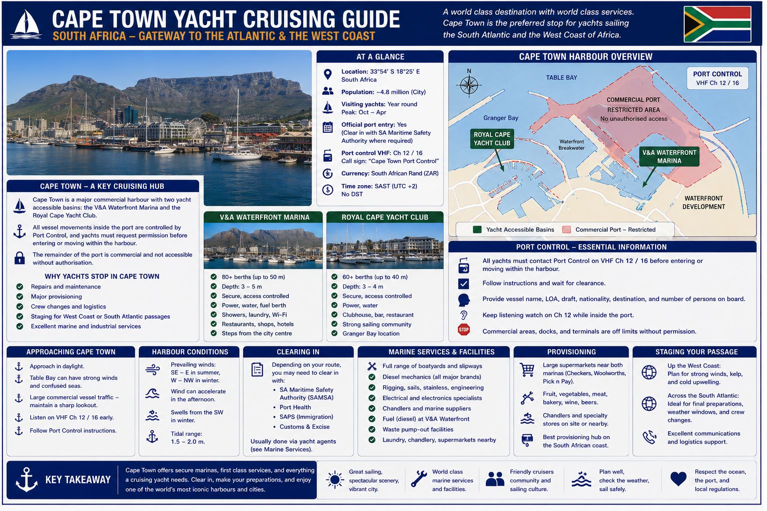
Cape Town Yacht Cruising Guide. Cape Town lies at the southwest corner of Table Bay on the Atlantic side of the Cape Peninsula. The port handles containers, general cargo, petroleum products, fishing vessels, cruise ships, naval support craft, research vessels and yachts. Table Bay extends between Green Point, Robben Island and the Blaauwberg coast. The city remains a departure and arrival point for Atlantic, Indian Ocean and Southern Ocean passages. International yachts use Cape Town for entry clearance, repairs, stores, crew changes and passage preparation
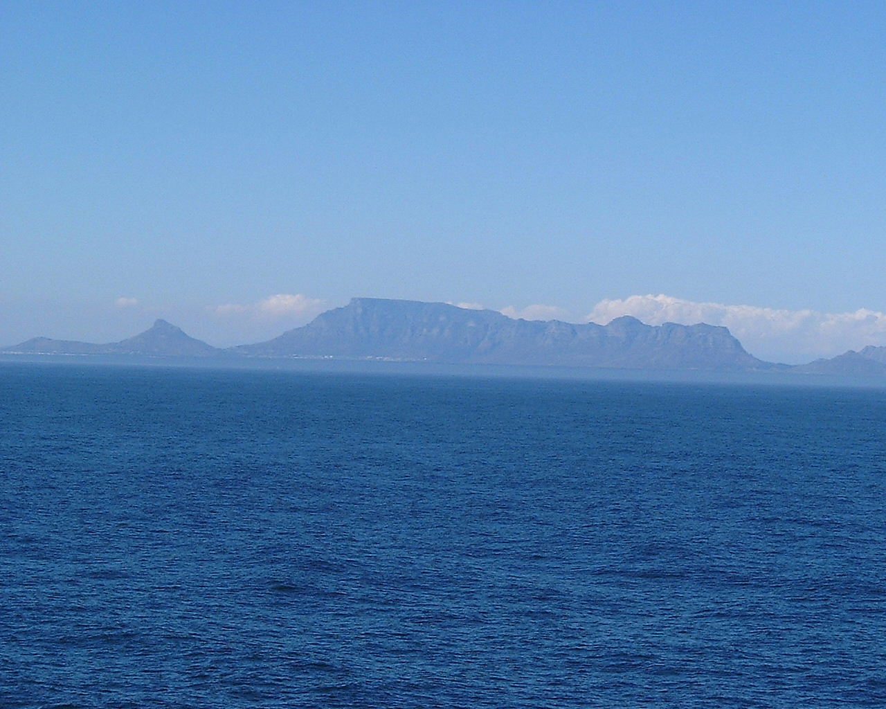
Table Bay is a shallow coastal basin with depths increasing from the eastern shore toward the bay entrance. Robben Island separates the northwest sector from the Atlantic approach and creates local current and wave effects around its reefs. The Benguela upwelling system controls sea temperature and contributes to fog formation along the coast. Winter fronts produce northwest wind and swell, while summer pressure systems produce southeast wind. The port remains operational throughout the year under vessel traffic control.
Welcome to the
Sailboat Liveaboard Website
Welcome to the Sailboat Liveaboard website. This site is operated by myself, John Payne, author of the Marine Electrical and Electronics Bible now in its 4th Edition. I am no self-proclaimed guru. Marine electrics, electronics and marine systems are my professional day job. As a yacht owner and frequent liveaboard my aim is to help you solve problems, save you money on expensive call outs or help get your boat problems resolved fast. This site also is advertising free and no Google or other ads and popups. It is entirely funded by sales of my book. It is also to provide great and practical cruising information about most places on the planet.
Cape Town Yacht Cruising Guide - History
Portuguese vessels reached the Cape during the late fifteenth century, and Table Bay became a watering and repair stop on routes between Europe and the Indian Ocean. The Dutch East India Company established a settlement beside the bay in 1652 to supply passing ships. An initial jetty was constructed in 1654, but vessels continued to anchor in the open roadstead and transfer cargo by boat. Winter northwest gales caused repeated wrecks because Table Bay had no enclosed harbour. The wreck of the Dutch ship Haarlem in 1647 and the survivors’ occupation ashore influenced the later decision to establish a permanent supply station.
A storm in May 1858 wrecked or drove ashore more than 30 vessels in Table Bay. Construction of the first harbour breakwater began in 1860, followed by the Alfred Basin and Victoria Basin. Duncan Dock opened during the twentieth century, and later reclamation created the container terminal and associated industrial port. Maritime archaeological remains occur beneath reclaimed sections of the foreshore and on the seabed of Table Bay, including wrecks from Dutch, British and other trading fleets. Known sites include the Haarlem, wreck deposits near the former shoreline, and multiple wrecks around Robben Island, Green Point and the Blaauwberg coast.
Cape Town Yacht Cruising
Guide - Approaches
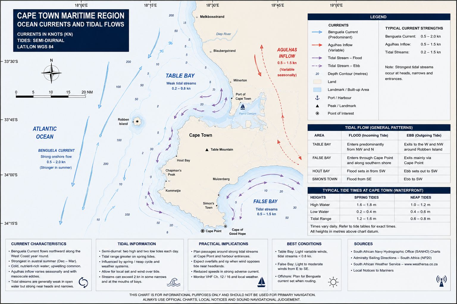
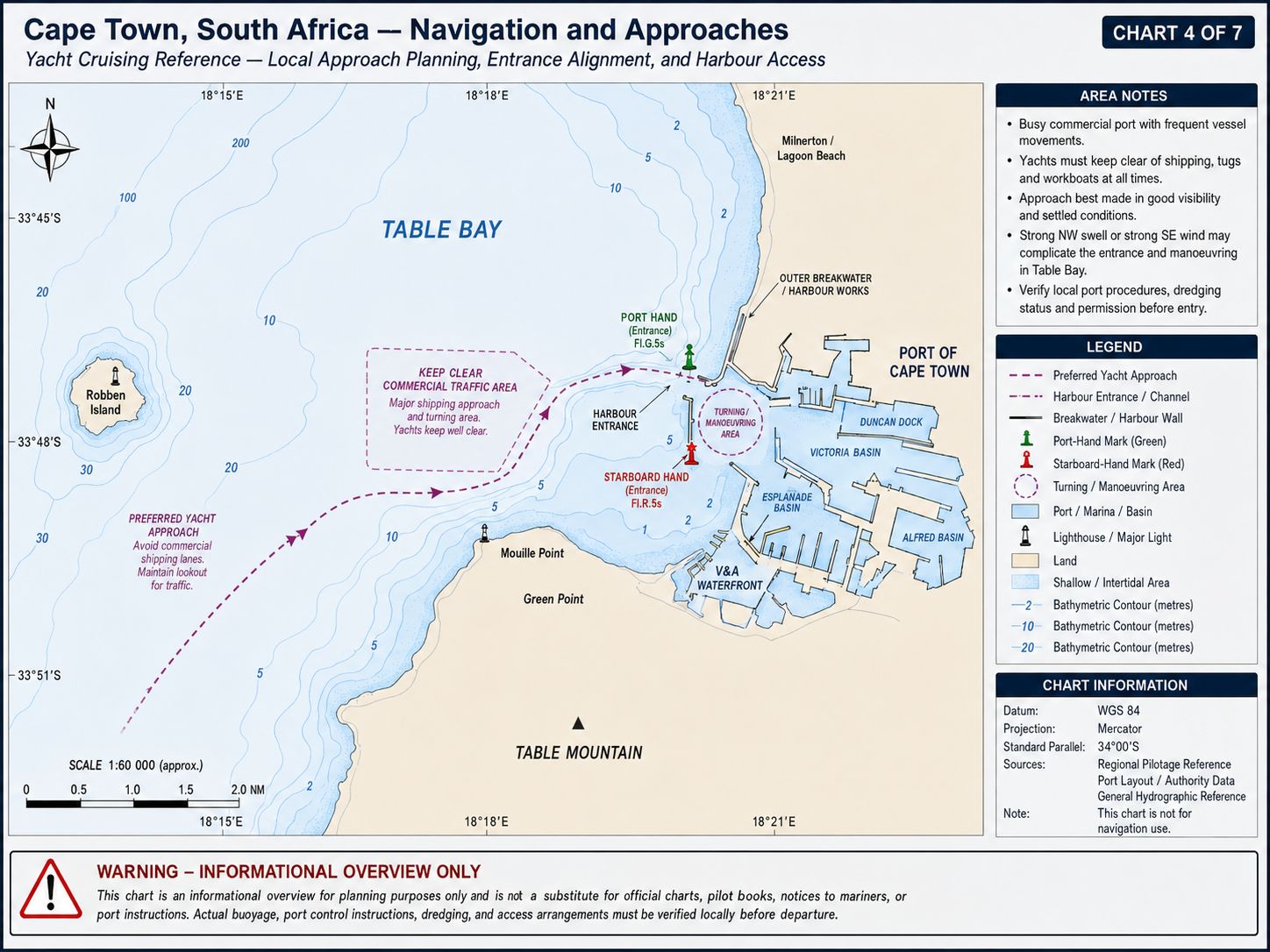
From the south, remain clear of the Cape Peninsula shore while passing Camps Bay, Sea Point and Green Point. The seabed west of Green Point contains rock ledges, wrecks and foul ground, with Atlantic swell breaking farther offshore during long-period conditions. Maintain water deeper than 30 metres until Green Point Lighthouse, Robben Island and the commercial entrance have been identified. Do not cut across the Mouille Point and Green Point reef areas. Fishing vessels, harbour tugs, pilot boats and ships joining the Table Bay traffic system operate throughout the approach.
From the northwest or north, identify Robben Island, Whale Rock and the charted traffic-separation system before closing Table Bay. Whale Rock lies south of Robben Island and is marked by a south-cardinal buoy. Reefs and kelp extend around Robben Island beyond the visible shoreline, and the island must not be rounded using visual distance alone. Commercial traffic approaches through charted routes south and west of Robben Island. Remain outside the dredged entrance channel until Cape Town Port Control has identified the yacht and issued movement instructions.
Cape Town Yacht Cruising Guide - Currents and Tidal Flows
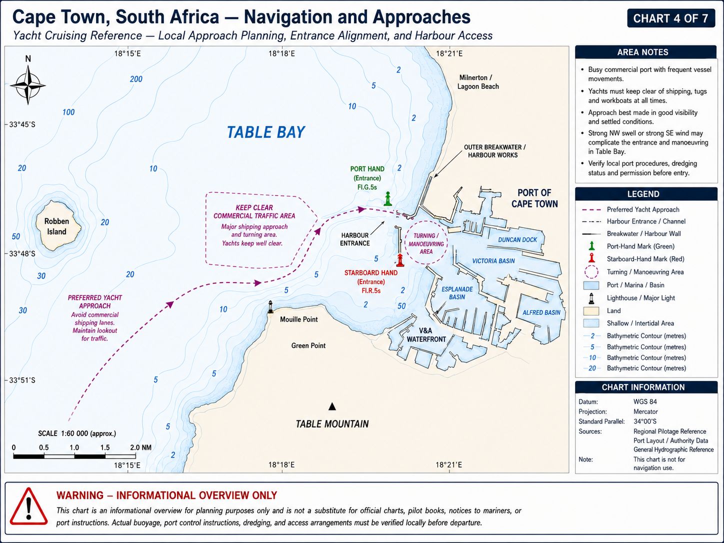
No fixed current runs through Table Bay at a constant direction or speed. Surface circulation is controlled by southeast and northwest winds, coastal upwelling, swell and water exchange around Robben Island. Sustained southeast wind generally drives surface water northward along the Cape Peninsula and westward or northwestward through sections of the bay. Northwest wind reverses this movement and drives surface water toward the southern and eastern shore. Wave-driven circulation near Robben Island can establish local currents that do not correspond with the wind recorded inside Cape Town harbour.
Cape Town has a semi-diurnal tide with two high waters and two low waters during each lunar day. The mean spring range is approximately 1.7–1.8 metres, while the neap range is approximately 0.6–0.8 metre. Tidal streams inside the commercial harbour are weak compared with tug wash, propeller flow and wind set. Tide height affects under-keel clearance at individual yacht berths, dry-dock sills and shallow sections of the Victoria and Alfred basins. The tidal stream becomes more apparent around Robben Island, Whale Rock, Green Point and the entrance to Granger Bay.
Cape Town Yacht Cruising Guide - Navigation
Call Cape Town Port Control on VHF Channel 14 before crossing the line between Green Point and Robben Island or entering the controlled approach. State the yacht’s name, call sign, position, length, beam, draught, last port, clearance status and requested marina. Maintain a listening watch on Channels 14 and 16 and keep AIS transmitting. Port Control operates continuously and can direct the yacht to hold outside, proceed toward the breakwater or wait for a commercial movement. Do not enter the dredged channel, cross ahead of a ship or pass between a tug and its assisted vessel without clearance.
The principal entrance channel is approximately 300 metres wide and carries about 15.9 metres at chart datum, with greater charted depths outside the dredged section. Enter between the main breakwater structures on the side of the channel allocated by Port Control. Yachts bound for Royal Cape Yacht Club proceed through Duncan Dock and follow the small-craft route to the marina. Yachts bound for the V&A Waterfront proceed toward the Victoria Basin and require separate bridge-control arrangements for the Swing Bridge and Bascule Bridge. Contact Swing Bridge on VHF Channel 71 before entering the bridge approach and do not hold in a commercial fairway while waiting for an opening.
Cape Town Yacht Cruising Guide - Chart Accuracy
Use South African chart SAN 1013, Approaches to Table Bay, for the outer approach and traffic routes. Use SAN 1014, Table Bay, for Robben Island, the commercial harbour entrance, Duncan Dock, Victoria Basin and the yacht-marina routes. SAN 136, Table Bay to False Bay, provides coastal passage coverage around the northern Cape Peninsula. The large-scale Table Bay chart is required from the Robben Island sector to the assigned berth.
The fixed breakwaters, dredged commercial channels and main harbour basins are surveyed for commercial navigation. Electronic charts do not provide live berth occupancy, bridge-opening status, marina fairway restrictions, temporary workboats or port construction. Depths at yacht berths can differ from the surrounding commercial basin. Current Notices to Mariners can alter buoy status, light operation and dredging information before a new chart edition is released. Compare the corrected chart, sounder and marina depth information throughout the final approach.
Cape Town Yacht Cruising Guide - Lighthouses and
Lights
Green Point Lighthouse — D5900. Green Point Lighthouse stands near Mouille Point on the southwest side of Table Bay. The square masonry tower is 16 metres high and has red-and-white diagonal bands. The focal height is approximately 20 metres. The characteristic is Fl W 10s, displaying one white flash every 10 seconds. The nominal range is approximately 22 nautical miles. The light marks the southwest side of Table Bay but does not mark a safe close-coastal route around Green Point. Rock, wrecks and foul ground lie offshore from the lighthouse. A fog signal operates during applicable reduced-visibility conditions. The light can remain visible while the commercial breakwater is obscured by rain or sea fog.
Robben Island Lighthouse — D5870. Robben Island Lighthouse stands on Minto Hill near the centre of Robben Island. The masonry tower is approximately 18 metres high, with a focal height of about 47 metres. The daymark is a white tower with a black vertical stripe and a red lantern roof. The characteristic is Oc W.R 7s, with a five-second light period followed by a two-second eclipse. The white light has a nominal range of approximately 24 nautical miles, with a red sector covering specified danger bearings.
The lighthouse marks the island but not the outer limit of its reefs. Whale Rock, kelp and shallow ground extend south and east of the island. Keep the charted clearance from the lighthouse regardless of apparent distance from the shore. Murray’s Bay Harbour lies on the northeast side and does not provide unrestricted yacht access.
Milnerton Lighthouse — D5910. Milnerton Lighthouse stands on Woodbridge Island on the eastern side of Table Bay. The cylindrical concrete tower is approximately 21 metres high. Its focal height is approximately 28 metres. The characteristic is Fl(3) W 20s, displaying three white flashes every 20 seconds. Its nominal range is approximately 25 nautical miles.
The light warns of the eastern Table Bay shore and its history of strandings. Its red sector covers bearings toward Robben Island and associated dangers. It is not an approach light for Cape Town harbour. A yacht approaching from the north must remain clear of the shallow Blaauwberg and Milnerton shoreline.
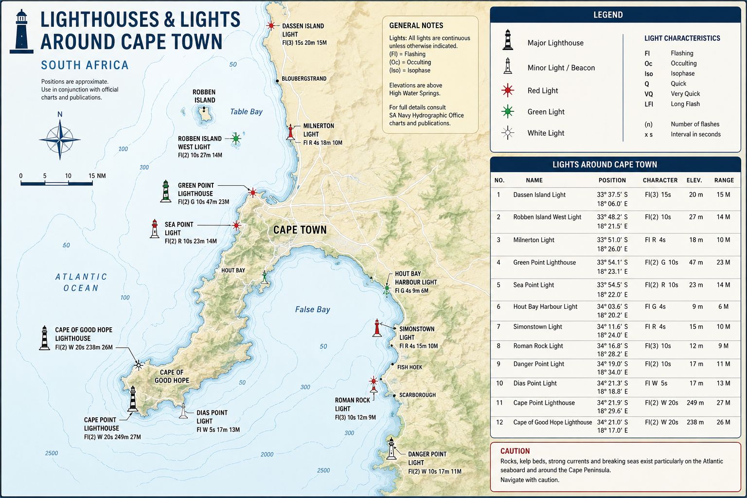
Main Breakwater and Harbour Entrance Lights. The Cape Town entrance structures carry lateral and sector lights shown on SAN 1014 and the current South African List of Lights. South Africa uses IALA Region A, with red lateral marks kept to port and green marks kept to starboard when entering. Commercial background lighting can obscure small navigation lights after dark. Confirm every characteristic from the corrected chart and current Notices to Mariners. The main breakwater light must not be used as the sole position reference. Spray, fog and container-terminal lighting can reduce its definition. Use radar ranges, AIS traffic information, the depth sounder and Port Control instructions with the visual marks. Report an extinguished or displaced light to Port Control.
Victoria and Alfred Basin Lights. The Victoria Basin, Alfred Basin and bridge approaches contain local navigation lights controlled within the V&A Waterfront harbour system. These marks identify bridge openings, quay ends and internal fairways. They do not replace permission from Port Control and bridge control. Floodlighting, ferry lights and waterfront buildings can conceal small vessels inside the basins.
Cape Town Yacht Cruising
Guide - Anchorage
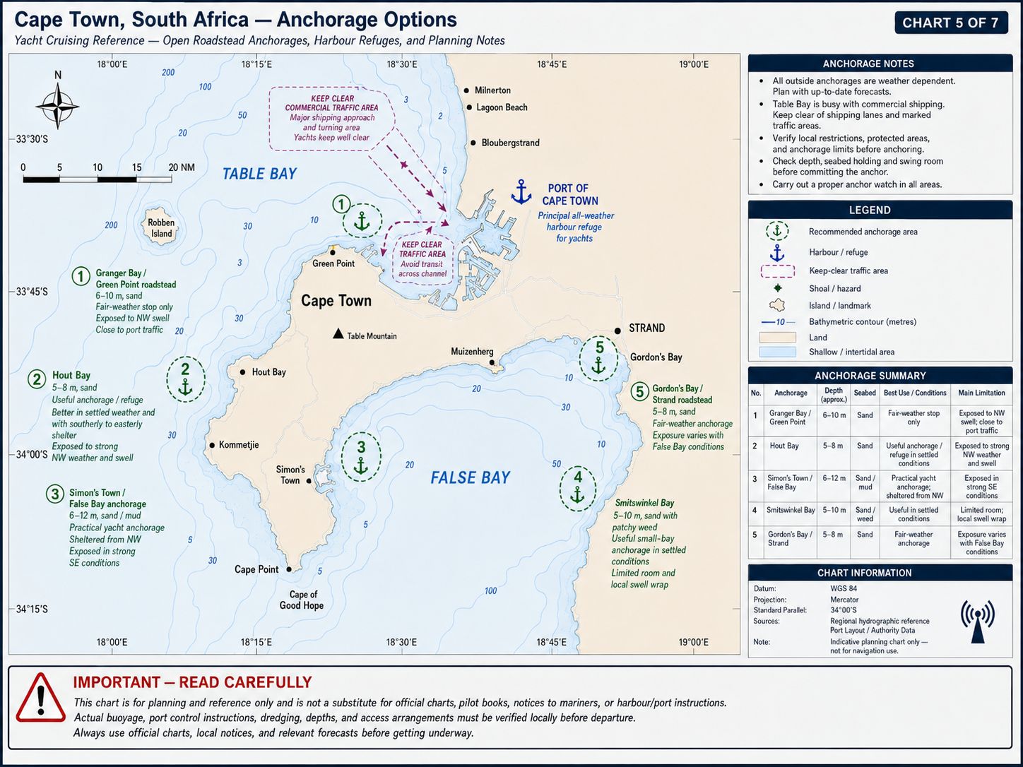
Anchoring within the Cape Town port limits is controlled by Port Control. No fixed yacht anchorage can be occupied without an assigned position. Commercial anchorage depths generally range from approximately 15–30 metres over sand, mud and areas of mixed ground. Holding is variable and deteriorates during sustained northwest wind and swell. Anchoring is prohibited in the dredged channel and its approaches, including the sector extending approximately 2 nautical miles north-northwest of the breakwater.
The Table Bay anchorage is exposed to northwest, west and southwest weather. During a winter gale, a vessel must keep its engine available and remain capable of leaving the anchorage. The lee shore includes the harbour entrance, foreshore and Blaauwberg coast. Port Control can order an anchored yacht to move or proceed seaward.
- Granger Bay Anchorage. Granger Bay lies east of Mouille Point and outside the private Granger Bay small-craft harbour. Anchor in approximately 5 metres over sand and shingle, clear of the Oceana Power Boat Club slipway, harbour entrances and small-craft routes. Holding is fair to secure where the anchor reaches a sand patch. Rock margins and existing ground tackle restrict the usable area. The position is protected from wind and swell between southwest and southeast. It is exposed to north, northwest and west wind. A winter northwest change makes the anchorage untenable because the shore lies directly downwind. Granger Bay is a short-term settled-weather position and not an alternative to a marina during frontal weather.
- Murray’s Bay, Robben Island. Murray’s Bay lies on the northeast side of Robben Island. Anchor outside the kelp in approximately 7–10 metres over sand and mixed ground. The ferry route into Murray’s Bay Harbour must remain clear. Do not enter the harbour or land on Robben Island without permission from the island authority. The anchorage has protection from southwest and west swell behind the island. It is exposed to north, northeast and southeast wind, and local currents can reach approximately 1–2 knots. Whale Rock and reefs south of the island restrict the approach. Use is limited to daylight and settled conditions with a verified escape route.
- V&A and RCYC Harbour Basins. Anchoring is prohibited inside the Royal Cape Yacht Club marina, Duncan Dock yacht fairways, Victoria Basin, Alfred Basin and V&A Marina unless the port or marina authority issues a direct emergency instruction. These waters contain private moorings, commercial traffic, bridges and turning areas. Use only the assigned berth or waiting position
Cape Town Yacht Cruising
Guide - Entry Formalities
Cape Town is a South African maritime port of entry and departure. International yachts must complete the national pre-arrival registration and provide the required notice before reaching South African waters. Arrival documents include vessel registration, crew list, passport details, last-port clearance, voyage information, insurance details and Customs declarations. Send changes to the estimated arrival time when the passage deviates from the submitted arrival plan.
Notify Port Control that the yacht requires international clearance before entering the harbour. Proceed to the berth allocated for clearance and keep all crew aboard until Port Health, Border Management, Immigration and Customs requirements have been completed. Do not land rubbish, food, animals or equipment before release. Keep passports, crew documents and the vessel’s entry record available for inspection.
Customs declarations cover cash, alcohol, tobacco, firearms, ammunition, controlled medicines, commercial goods and equipment intended for sale. Firearms and ammunition require declaration and separate control. Meat, dairy products, plants, seeds, fresh produce and animal products remain subject to agricultural and biosecurity inspection. International waste must use an approved disposal route.
Cape Town is the required veterinary-processing location for several categories of animals arriving by yacht. Pets require the applicable import permit, health certificate, vaccination record, identification and advance notification. An animal arriving through another South African port can be required to remain aboard until transferred to the authorised Cape Town process. Do not land a pet before veterinary release.
International yachts completing a coastwise voyage after Cape Town retain the Customs and Immigration documents issued at entry. A coastwise passage plan is required where applicable before moving to another South African harbour. International departure clearance must be completed before sailing from South African waters. Crew must remain available until the departure process is closed.
Starlink and other satellite communication terminals remain subject to ICASA service licensing, spectrum and equipment type-approval requirements. A foreign roaming account does not create an exemption from South African law. Keep the terminal inactive where lawful authority has not been established. Port security can restrict transmitting equipment in controlled areas.
Drone operation requires compliance with South African civil aviation rules, port security, property controls and local airspace restrictions. Do not launch from Royal Cape Yacht Club, the V&A Marina, a commercial quay or a yacht within the port without permission. Flights over ships, container operations, fuel installations, security points, crowds and private vessels require the applicable approvals. Cape Town International Airport, military facilities and helicopter operations create additional airspace constraints.
Cape Town Yacht Cruising
Guide - Marina Facilities
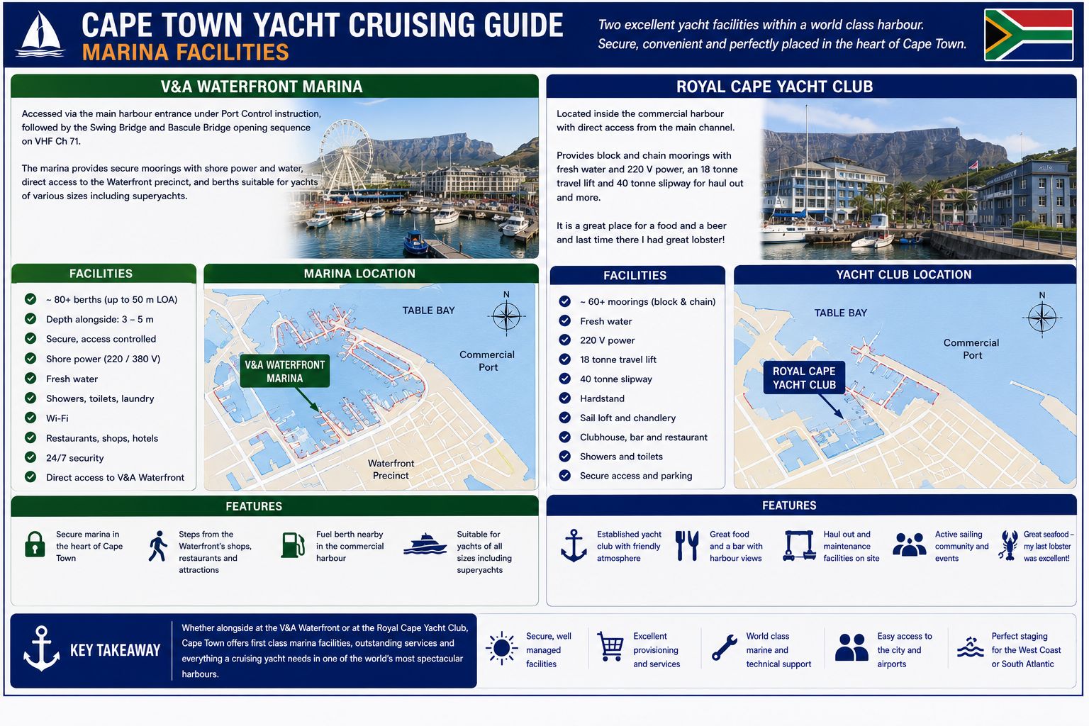
Royal Cape Yacht Club. Royal Cape Yacht Club lies in Duncan Dock inside the commercial port. The marina provides approximately 386 block-and-chain moorings for members and visiting yachts. Every berth has fresh water, lighting and 220-volt shore power. Advance booking is required. A vessel longer than 65 feet or drawing 3 metres or more must provide its dimensions before arrival and obtain specific acceptance.
The route from the main harbour entrance crosses commercial port water. Port Control clearance remains required for every arrival and departure. Fishing vessels, tugs, pilot boats and workboats operate beside the marina approach. Maintain minimum wash and proceed directly to the assigned berth. Do not enter a vacant pen without an allocation.
Facilities include toilets, showers, laundry access, Wi-Fi, waste collection, clubhouse facilities and controlled vehicle access. The marina is inside an industrial-security area, and crew or contractors can require gate registration. Water and electricity connections must remain inside the allocated berth. Do not place lines, cables or equipment across service roads or adjacent berths.
Repair and chandlery businesses operate beside or near the club. The marina lies within road access of Paarden Eiland, Woodstock and the Cape Town marine-industrial area. Heavy lifting, mast removal and hull work require a booked contractor and an approved working area. The commercial syncrolift and dry docks are not club facilities and are allocated separately.
V&A Waterfront Marina. V&A Waterfront Marina lies within the Alfred Basin at the southeast side of the old harbour. Access from Table Bay requires entry through the commercial port, transit of Victoria Basin and passage through the Swing Bridge and Bascule Bridge. Contact Port Control on Channel 14 and bridge control on Channel 71. A berth and bridge passage must be confirmed before entering the internal approach.
The marina has a limited number of visitor berths and handles yachts by advance booking. Published visitor facilities include water, electricity, toilets, showers, laundry, Wi-Fi and fuel access. Depth is berth-specific and must be confirmed against the yacht’s loaded draught. Bridge openings, pedestrian traffic and scheduled harbour operations can delay entry or departure.
The basin contains ferries, charter boats, workboats and private vessels. Keep clear of ferry landing points and bridge holding areas. Do not remain under sail inside the basin. Shore access leads directly into the controlled V&A property, but marina gates and vessel areas remain restricted.
A new V&A superyacht facility was under construction during 2026 for vessels in the 30–90-metre range. It includes planned stern-to and beam-on positions near Quay Seven. These berths are not available to a cruising yacht until the facility has been commissioned and berth management has accepted the vessel. Current construction boundaries take priority over older marina plans.
Granger Bay Harbour. Granger Bay Harbour contains private and institutional small-craft moorings. It is not an unrestricted visiting-yacht marina. The entrance and basin are not suitable as a waiting area for an unallocated cruising yacht. Use requires direct approval from the berth operator.
Cape Town Yacht Cruising
Guide - Local Weather
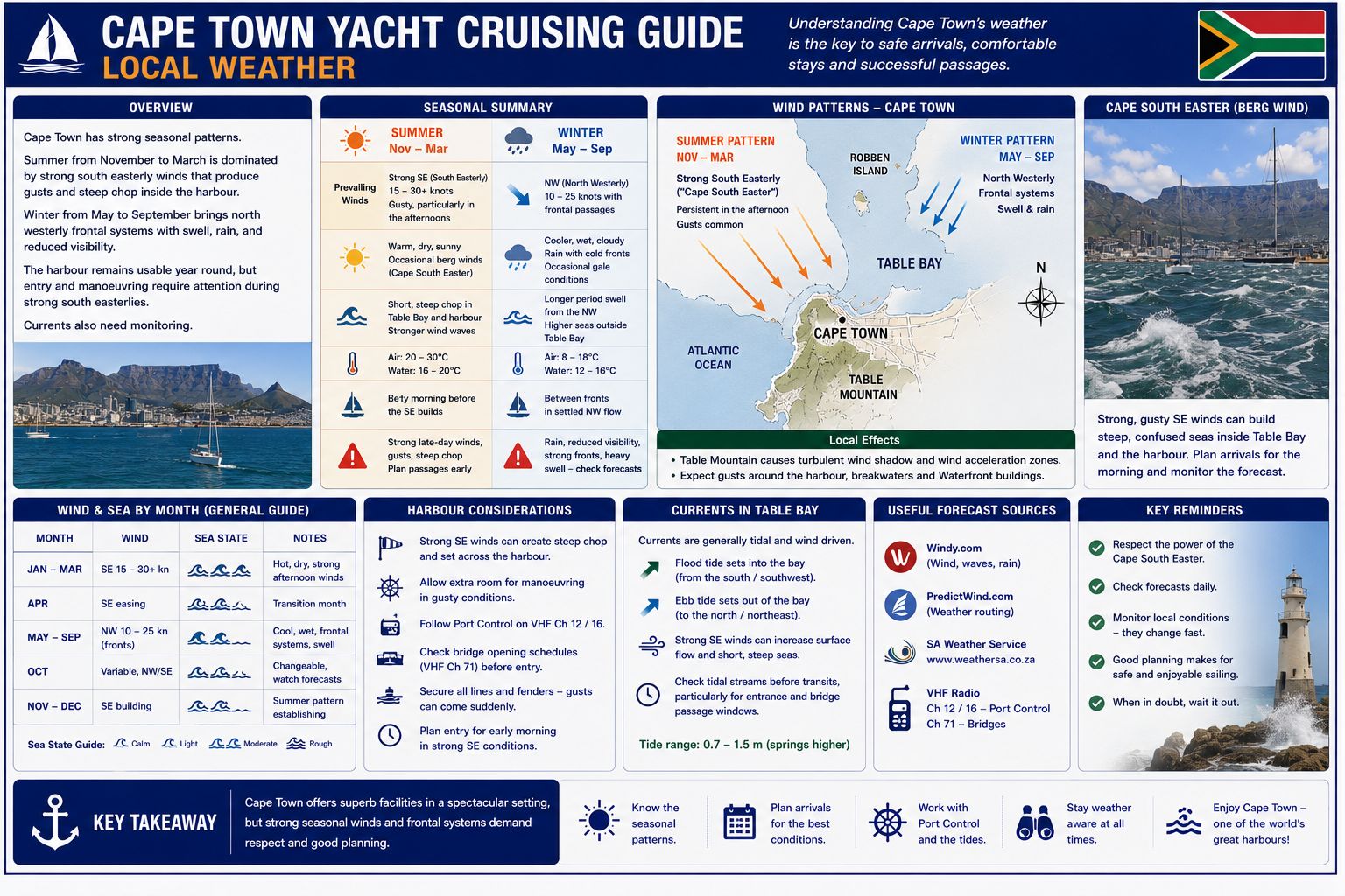
Cape Town has a winter frontal cycle from approximately May to September. A front normally begins with falling pressure, increasing north or northwest wind, cloud and rain. The wind shifts through west to southwest after the front passes, while long-period Atlantic swell continues to enter Table Bay. Northwest wind acts across the full bay and produces an onshore sea against the port, Green Point and the foreshore. Strong frontal conditions can suspend small-craft movements and make the Table Bay anchorage untenable.
Summer conditions from approximately October to March are controlled by the South Atlantic high-pressure system. Southeast wind develops when pressure rises south or southwest of the Cape Peninsula and lower pressure exists over the interior. Several days of southeast wind cause coastal upwelling and a reduction in sea temperature. Fog forms when moist air crosses the cold water and can obscure Robben Island, the breakwater and Table Mountain while visibility remains clear ashore. The sea state outside the breakwater can remain moderate during southeast wind, but gust strength inside the port can exceed the offshore forecast.
Cape Town Yacht Cruising Guide - Local Winds
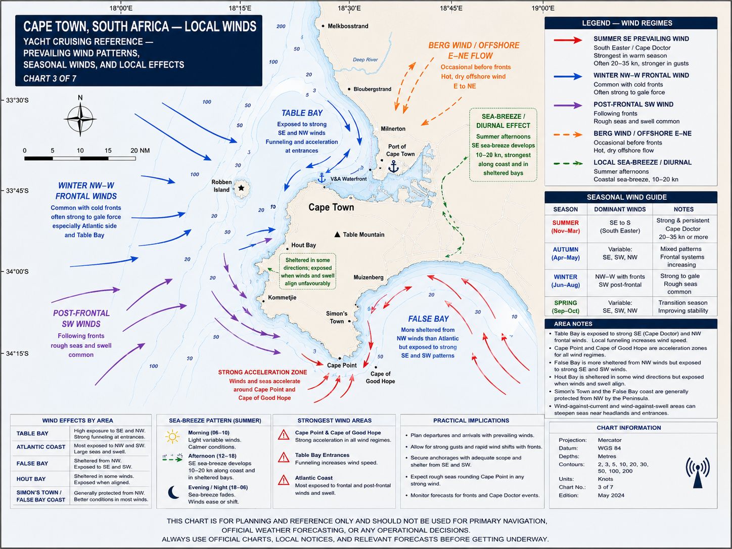
The South-Easter, also called the Cape Doctor, is the main summer wind. It crosses the Cape Peninsula and reaches Table Bay from southeast, south or east according to local terrain. Wind acceleration occurs between Table Mountain, Devil’s Peak and the northern peninsula, producing gusts across Duncan Dock and the Royal Cape Yacht Club marina. Sustained speeds of 25–35 knots occur during established cycles, with stronger gusts during pressure-gradient events. A Black South-Easter carries low cloud, rain or reduced visibility and can continue without the clear conditions associated with a dry southeast cycle.
The North-Wester is the controlling winter wind for Table Bay. It blows directly into the bay and generates short-period waves, surge and load on marina pontoons and mooring systems. A west or southwest wind follows the frontal passage and can maintain ocean swell after the pressure has started rising. Berg winds arrive from north or northeast before some cold fronts and produce dry air, higher temperature and haze before the northwest change.
Cape Town Yacht Cruising
Guide - Provisioning
Supermarkets. Pick n Pay V&A Waterfront, Woolworths Food V&A Waterfront, SPAR Cape Quarter and Checkers outlets in the Cape Town central area provide the main supermarket supply near the harbour. Pick n Pay and Woolworths are inside Victoria Wharf, less than 1 kilometre from V&A Marina and approximately 4–5 kilometres by road from Royal Cape Yacht Club. Woolworths publishes trading from 09:00–21:00 daily. Pick n Pay normally trades through the morning and evening, with current public listings indicating opening until approximately 21:00.
Cape Quarter lies approximately 3 kilometres by road from Royal Cape Yacht Club and about 2 kilometres from the V&A Marina. Central-city supermarket access requires road transport from RCYC because pedestrian routes pass through commercial-port gates and industrial roads. Online ordering and road delivery are available, but the driver requires the correct marina gate and berth contact.
Markets. The Oranjezicht City Farm Market operates at the corner of Granger Bay Boulevard and Dock Road beside the V&A Waterfront. Published hours are Saturday from 08:00–14:30 and Sunday from 08:30–14:30. The Wednesday night market operates from 16:00–21:30 outside the June–July closure period. The market carries vegetables, fruit, bread, eggs, meat, cheese, preserves and products from Western Cape growers and food producers.
The Oranjezicht farm site at 87 Upper Orange Street operates Monday to Friday from 08:00–14:00 and Saturday from 08:00–12:00. It sells smaller quantities than the waterfront market and lies approximately 5 kilometres by road from the marinas. Bulk passage stores remain dependent on supermarkets or commercial suppliers.
Fish Markets. Ocean Jewels Fresh Fish operates from the Woodstock Exchange at 66 Albert Road, approximately 4–5 kilometres by road from Royal Cape Yacht Club. Current retail and collection hours require confirmation before travel, with weekday operation forming the normal schedule. The business supplies fresh and frozen seafood and can arrange delivery.
The V&A Waterfront and central Cape Town contain licensed seafood retailers and supermarket fish counters. Kalk Bay Harbour and Hout Bay provide further direct retail sources, but both require road travel from Cape Town harbour. Commercial fishing quays inside Cape Town port remain restricted. Do not purchase from a vessel or enter a landing area without authorisation.
Regional seafood includes snoek; Cape hake, called stokvis in Afrikaans; yellowtail, called geelstert; kob, called kabeljou; geelbek or Cape salmon; hottentot seabream; red roman, called rooi roman; kingklip; Cape Hope squid, called chokka; yellowfin tuna; longfin tuna; mussels and West Coast rock lobster, called kreef, when legal supply is available. Quotas, closed seasons, marine protected areas and weather determine availability
Cape Town Yacht Cruising
Guide - Local Cuisine
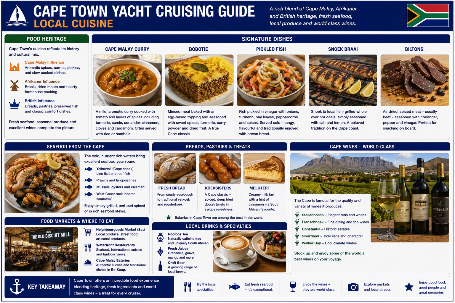
Cape Town cuisine combines Cape Malay cooking, West Coast seafood, inland farming products and food introduced through the city’s maritime trade. Snoek braai consists of snoek cooked over coals with salt, lemon, butter or apricot glaze. Ingelegde vis is fish preserved with vinegar, onion, turmeric and spices. Hake and slap chips consists of fried hake and thick-cut chips. Yellowtail, tuna and line fish are grilled or seared when legal supply is available.
Bobotie is spiced minced meat baked under an egg topping. Denningvleis is meat cooked with a sweet-and-sour spice and acid mixture. Waterblommetjiebredie combines lamb with waterblommetjies harvested from seasonal Western Cape wetlands. Cape Malay curry uses meat, chicken or fish with turmeric, coriander, cumin, cinnamon and other spices. Bredie describes a slow-cooked meat and vegetable stew.
Gatsby is a Cape Town bread roll filled with chips and combinations of meat, chicken, fish or other fillings. Koesisters are spiced yeast doughnuts finished with syrup and coconut. Koeksisters are plaited fried pastries soaked in syrup and are a separate product. Roosterkoek is bread cooked over coals. Western Cape produce includes wine grapes, apples, pears, citrus, stone fruit, olives, cheese and wheat products.
Cape Town Yacht Cruising Guide - Beverages
Cape Town lies beside the Constantia wine district and within road access of Stellenbosch, Durbanville, Paarl and Franschhoek. Constantia producers include Groot Constantia, Klein Constantia, Buitenverwachting, Steenberg and Constantia Uitsig. Regional production includes Sauvignon Blanc, Chenin Blanc, Chardonnay, Pinotage, Cabernet Sauvignon, Shiraz and blended wines. Vin de Constance is a sweet Muscat-based Constantia wine.
Cape Town beer producers include Devil’s Peak Brewing Company and Woodstock Brewery, with additional beer supplied from breweries elsewhere in the metropolitan area and Western Cape. National brands include Castle Lager, Castle Lite, Carling Black Label and Hansa Pilsener. Local spirits include gin, brandy and rum produced within the Cape Town metropolitan area. South African brandy and Amarula cream liqueur are stocked through licensed outlets
Cape Town Yacht Cruising
Guide - Fuel Supplies
Diesel is available within the Cape Town port and marina system. Royal Cape Yacht Club has access to marine diesel through the club fuel arrangement, subject to current operating hours and berth availability. V&A Waterfront Marina lists fuel as an available service, with supply controlled through the marina or harbour fuel point. Confirm the dispensing location, grade, hose reach, payment method and opening time before moving the yacht.
Commercial bunker suppliers can deliver larger quantities at an approved berth. A tanker or bonded-fuel transfer requires port permission, security clearance and an agreed hose route. International yachts purchasing bonded fuel for departure must complete the supplier and Customs procedure before transfer. Do not move from the allocated berth until Port Control or marina management has accepted the operation.
Road diesel is available throughout Cape Town, but repeated container transfer through a commercial-port security gate requires approval. Use approved, sealed containers and keep them clear of electrical connections and walkways. Do not store portable fuel on a marina finger.
Take a clear sample from the first fuel transferred and inspect it for free water and sediment. Use the yacht’s deck-fill strainer and primary water-separating filter. Position absorbent material around the deck fill and block scuppers before transfer. Report every spill immediately to marina management and Port Control.
Cape Town Yacht Cruising
Guide - Water Supplies
Fresh municipal water is available at every Royal Cape Yacht Club mooring under the current marina arrangement. V&A Waterfront Marina provides water at equipped berths. Confirm the outlet belonging to the allocated position before connecting. Do not connect to a commercial washdown or fire-service outlet.
Cape Town municipal water is treated to drinking-water standards, but the water received aboard depends on the shore connector, hose and yacht tank. Flush the outlet before filling. Use a hose reserved for potable water and keep its end off the pontoon and clear of harbour water. Apply onboard filtration where fitted.
City restrictions, pipe work and reduced pressure can affect supply. Obtain marina approval before taking a large volume or leaving a hose connected for an extended period. Do not leave a filling hose unattended. Bottled water is available from the V&A supermarkets and city suppliers.
Mechanical
and Electrical Repairs Resource
Why not get a copy of my book The Marine and Electrical and Electronics Bible 4th Edition. Your complete systems guide. 650 pages of practical advice. In Australia and New Zealand order a copy through Boat Books. UK and European boats can buy the UK Edition Here. US and Canadian boats can get the US Edition Order Here. Marine systems are my profession so let me help you.

Cape Town Yacht Cruising
Guide - Marine Services
Cape Town contains the main yacht-service concentration in South Africa. Service areas include Royal Cape Yacht Club, the V&A Waterfront, Paarden Eiland, Woodstock, Salt River and Montague Gardens. Work available includes diesel repair, electrical installation, marine electronics, refrigeration, rigging, sailmaking, composite repair and underwater inspection. Contractor entry into the port requires gate approval.
Seascape Marine Services at Paarden Eiland is the authorised Yanmar recreational-marine distributor and service agent. The company provides Yanmar sales, service and parts. Attendance at a marina requires a booked service call and security access.
VETUS MAXWELL South Africa operates from Paarden Eiland as the South African VETUS branch. It supplies VETUS engines, steering, exhaust, fuel, electrical, plumbing and deck systems, together with Maxwell anchoring equipment. The branch provides product support and parts. Seaport Supply Cape Town is also listed as a Maxwell authorised service centre and distributor. Volvo Penta support is available through the manufacturer’s South African dealer network.
Cape Town contains marine-electronics suppliers and installers for Raymarine, B&G and Simrad equipment. Chandlery and yacht equipment suppliers operate in Paarden Eiland and the central city. Seaport Supply carries deck hardware, navigation equipment, safety equipment, plumbing and commercial marine products.
OSASA - South African Yacht Assistance
The Ocean Sailing Association of Southern Africa (OSASA) came into being during the COVID pandemic crisis where they actively assisted entry to South Africa by cruising yachts into its various ports. It is a non-profit company created to liaise with Maritime officials to facilitate entry to South African ports at the time. OSASA was assigned by the SA Department of Transport to handle the mandatory pre-arrival authorisation (PAN) for all incoming non-SOLAS yachts, both local and foreign. OSASA services include the following:
- Manage and update the online registration portal for incoming non-SOLAS vessels
- Manage the pre-arrival authorisation (PAN) process with the Department of Transport for incoming small vessels at the Ports of Entry
- Provide up-to-date information for cruising yachts navigating South African ports and coastal waters
- Develop and maintain a good working relationship with SA maritime authorities and port officials, and with local offshore yacht clubs and marinas
- Work with local offshore clubs and marinas to develop and enhance their facilities
Cruising yacht visitors are encouraged to contact OSASA at the portal link above. They are a group of willing and like minded volunteers along the South African coastline and will assist with the needs of cruising yachts. This group is known as the OSASA Port Ambassadors and will assist cruising yachts with anything that may be required. Anything from entry procedures right down to directing you to the nearest dentist or barber and anything in-between. There is a published list on the OSASA website as well as on the Sail to South Africa WhatsApp group of the individual OSASA port Ambassadors. Ports and marinas that are covered are Richards Bay; Durban; East London; Port Elizabeth; Port St. Francis; Knysna; Mossel Bay; Gordon's Bay, False Bay YC (Simon's Town), Hout Bay, Saldanha Bay; Port Owen; Cape Town (V&A Waterfront and Royal Cape YC)
Cape Town Yacht Cruising
Guide - Local Etiquette
Cape Town harbour is a controlled commercial port. Port Control instructions take priority over yacht-race procedures, marina arrangements and sail-training activity. Keep clear of ships, tugs, pilot boats, fishing vessels and security launches. Do not cross a commercial fairway without a confirmed traffic gap.
Royal Cape Yacht Club lies within an industrial port. Carry identification and use the assigned security gate. Register visitors, delivery drivers and contractors before arrival. Do not photograph container operations, security points, vessels or port infrastructure after a restriction has been issued.
The V&A Waterfront contains public areas beside controlled marina and harbour areas. Public access to a quay does not grant access to a yacht, bridge-control point, ferry berth or working vessel. Use the assigned marina gate and keep private pontoons closed. Do not obstruct ferries or bridge movements.
Ask permission before boarding another vessel, entering a workshop or photographing workers and crews. English, Afrikaans and isiXhosa are used throughout Cape Town. Goeie môre means good morning in Afrikaans, while Molo is an isiXhosa greeting to one person. State the yacht’s registered name, berth number and measured draught when dealing with Port Control or marina staff.


Cape Town Yacht Cruising
Guide - Security
Shore‑side security in Cape Town requires a practical, situational approach rather than alarmism. The areas immediately around the V&A Waterfront and the Royal Cape Yacht Club are controlled, patrolled, and generally predictable, but security changes quickly once outside these precincts. Moving through the CBD, Green Point, Woodstock, or Paarden Eiland requires normal urban caution: valuables kept out of sight, phones not used openly on pavements, and bags kept closed and held securely. Opportunistic theft is the primary issue rather than targeted crime, and it typically occurs in crowded streets, transport hubs, or when crews are distracted during provisioning runs.
Taxi drop‑offs and loading areas should be used directly rather than walking gear through side streets. After dark, movement should be limited to well‑lit main routes or direct vehicle transport rather than walking between districts. Dinghies left ashore must be locked, and outboards should be secured with a secondary lock. When provisioning in Green Point or the CBD, crews normally load directly into a taxi at the supermarket entrance rather than moving goods across car parks or pavements. Within the Waterfront precinct, security presence is continuous, but crews still avoid leaving bags unattended or displaying electronics openly.
Cape Town Yacht Cruising
Guide - Summary
Cape Town is a controlled commercial port and South African maritime port of entry with two primary yacht-marina systems. Entry requires Port Control clearance on VHF Channel 14, separation from commercial traffic and a confirmed berth at Royal Cape Yacht Club or the V&A Waterfront Marina. The port provides international clearance, fuel, potable water, provisioning, haul-out access and marine technical support. These harbour and service arrangements define the Cape Town Sailing and Cruising Guide. Cape Town Yacht Cruising Guide for all you need to know.